
-
Federal
Probabilistic Freeze-Thaw Record for the Northern Hemisphere, 2016-2020 recent views
National Aeronautics and Space Administration —
This dataset provides a probabilistic freeze/thaw (FT) data record from 2016 to 2020 for the Northern Hemisphere derived using a deep learning model (U-Net). The... -
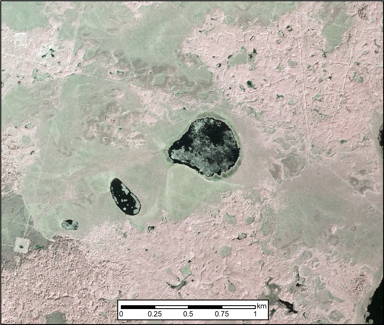
Federal
ABoVE: AirSWOT Color-Infrared Imagery Over Alaska and Canada, 2017 recent views
National Aeronautics and Space Administration —
This dataset contains georeferenced three-band orthomosaics of green, red, and near-infrared (NIR) digital imagery at 1m resolution collected over selected surface... -
Federal
LiDAR Surveys over Selected Forest Research Sites, Brazilian Amazon, 2008-2018 recent views
National Aeronautics and Space Administration —
This dataset provides the complete catalog of point cloud data collected during LiDAR surveys over selected forest research sites across the Amazon rainforest in... -
Federal
AIRS/Aqua L1B Near Real Time (NRT) Infrared (IR) geolocated and calibrated radiances V005 (AIRIBRAD_NRT) at GES DISC recent views
National Aeronautics and Space Administration —
WARNING: On 2021/09/23 the EOS Aqua executed a Deep Space Maneuver (DSM). In the DSM, the spacecraft is turned such that the normal Earth field of regard is deep... -
Federal
GLDAS Catchment Land Surface Model L4 daily 0.25 x 0.25 degree GRACE-DA1 V2.2 (GLDAS_CLSM025_DA1_D) at GES DISC recent views
National Aeronautics and Space Administration —
NASA Global Land Data Assimilation System Version 2 (GLDAS-2) has three components: GLDAS-2.0, GLDAS-2.1, and GLDAS-2.2. GLDAS-2.0 is forced entirely with the... -
Federal
Global Landslide Nowcast from LHASA L4 1 day 1 km x 1 km version 1.1 (Global_Landslide_Nowcast) at GES DISC recent views
National Aeronautics and Space Administration —
The Landslide Hazard Analysis for Situational Awareness (LHASA) model identifies locations with high potential for landslide occurrence at a daily temporal... -
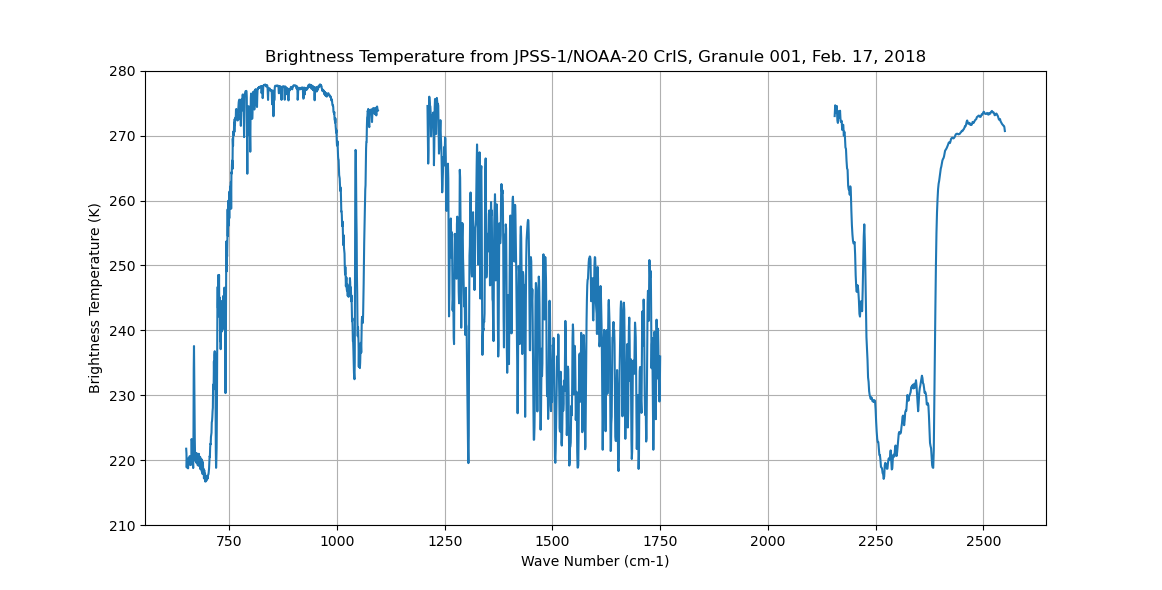
Federal
Sounder SIPS: Sun Synchronous 13:30 orbit Climate Hyperspectral InfraRed Product (CHIRP): Calibrated Radiances from JPSS-1/NOAA-20, V2 (SNDR13CHRP1J1Cal) at GES DISC recent views
National Aeronautics and Space Administration —
The Climate Hyperspectral Infrared Radiance Product (CHIRP) is a Level 1 radiance product derived from Atmospheric Infrared Sounder (AIRS) on EOS-AQUA and the Cross-... -
Federal
MODIS/Terra Calibrated Radiances 5-Min L1B Swath 1km NGDA recent views
National Aeronautics and Space Administration —
The MODIS/Terra Calibrated Radiances 5Min L1B Swath 1km data set contains calibrated and geolocated at-aperture radiances for 36 discrete bands located in the 0.4 to... -
Federal
NPP Tropical Forest: Maui, Hawaii, U.S.A., 1996-1997, R1 recent views
National Aeronautics and Space Administration —
This data set contains one data file (.csv format) that quantifies net primary productivity (NPP) as a function of rainfall in mesic to wet montane rainforests on the... -
Federal
Carbon Monitoring System Carbon Flux Total Prior L4 V3 (CMSFluxTotalPrior) recent views
National Aeronautics and Space Administration —
This dataset provides the Prior for Total Carbon Flux. The NASA Carbon Monitoring System (CMS) is designed to make significant contributions in characterizing,... -
Federal
GOES-R PLT ER-2 Flight Navigation Data V1 recent views
National Aeronautics and Space Administration —
The GOES-R PLT ER-2 Flight Navigation Data dataset consists of multiple altitude, pressure, temperature parameters, airspeed, and ground speed measurements collected... -
Federal
Methane Emissions from Dairy Sources (Vista-CA), State of California, USA, 2019 recent views
National Aeronautics and Space Administration —
This dataset provides estimates of methane (CH4) emissions from dairies in California at a resolution of 0.1 degrees (~ 10 km x 10 km) for the year 2019. The mapped... -
Federal
VIIRS/JPSS1 Vegetation Indices 16-Day L3 Global 500m SIN Grid V002 recent views
National Aeronautics and Space Administration —
The NOAA-20 Visible Infrared Imaging Radiometer Suite (VIIRS) (https://lpdaac.usgs.gov/dataset_discovery/viirs) Vegetation Indices (VJ113A1) Version 2 data product... -
Federal
BlueFlux: Dissolved Carbon and Greenhouse Gases recent views
National Aeronautics and Space Administration —
This dataset provides dissolved carbon (dissolved inorganic carbon and dissolved organic carbon), greenhouse gases, dissolved organic matter optical, and hydrological... -
Federal
MODIS/Aqua Cloud Mask and Spectral Test Results 5-Min L2 Swath 250m and 1km NGDA recent views
National Aeronautics and Space Administration —
The MODIS/Aqua Cloud Mask and Spectral Test Results 5-Min L2 Swath 250m and 1km product consists of global cloud mask quality assurance and other ancillary... -
Federal
MODIS/Aqua Calibrated Radiances 5-Min L1B Swath 250m NGDA recent views
National Aeronautics and Space Administration —
The MODIS/Terra Calibrated Radiances 5-Min L1B Swath 250m data set contains calibrated and geolocated at-aperture radiances for 2 discrete bands located in the 0.62... -
Federal
Siberian Boreal Forest Aboveground Biomass and Fire Scar Maps, Russia, 1969-2007 NGDA recent views
National Aeronautics and Space Administration —
This data set provides 30-meter resolution mapped estimates of Cajander larch (Larix cajanderi) aboveground biomass (AGB), circa 2007, and a map of burn perimeters... -
Federal
OCO-2 Level 2 bias-corrected XCO2 and other select fields from the full-physics retrieval aggregated as daily files, Retrospective processing V11.1r (OCO2_L2_Lite_FP) at GES DISC recent views
National Aeronautics and Space Administration —
Version 11r is the current version of the data set. Older versions will no longer be available and are superseded by Version 11r. The OCO-2 Lite files contain bias-... -
Federal
GPM Ground Validation Campaign Reports OLYMPEX V1 recent views
National Aeronautics and Space Administration —
The GPM Ground Validation Campaign Reports OLYMPEX dataset consists of flight reports, weather forecasts, instrument reports, scientist summaries, and plan-of-day... -
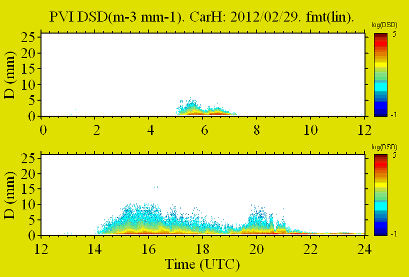
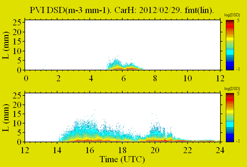
Federal
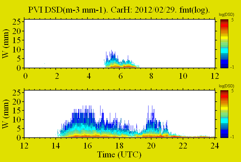
GPM GROUND VALIDATION PRECIPITATION VIDEO IMAGER (PVI) GCPEX V1 recent views
National Aeronautics and Space Administration —
The GPM Ground Validation Precipitation Video Imager (PVI) GCPEx dataset collected precipitation particle images and drop size distribution data from November 2011...

Official websites use .gov
A
.gov website belongs to an official government
organization in the United States.
Secure .gov websites use HTTPS
A
lock (
) or https:// means you’ve safely connected to
the .gov website. Share sensitive information only on official,
secure websites.