
-
Federal
Global Vegetation Greenness (NDVI) from AVHRR GIMMS-3G+, 1981-2022 recent views
National Aeronautics and Space Administration —
This dataset holds the Global Inventory Modeling and Mapping Studies-3rd Generation V1.2 (GIMMS-3G+) data for the Normalized Difference Vegetation Index (NDVI). NDVI... -
Federal
Arctic Vegetation Plots at Atqasuk, Alaska, 1975, 2000, and 2010 recent views
National Aeronautics and Space Administration —
This data set provides vegetation species abundance data collected in 1975 from 60 sites on the Arctic Coastal Plain near Atqasuk, Alaska, as well as environmental... -
Federal
LiDAR Surveys over Selected Forest Research Sites, Brazilian Amazon, 2008-2018 recent views
National Aeronautics and Space Administration —
This dataset provides the complete catalog of point cloud data collected during LiDAR surveys over selected forest research sites across the Amazon rainforest in... -
Federal
ABoVE: Photochemical Reflectance and Tree Growth, Brooks Range, Alaska, 2018-2019 recent views
National Aeronautics and Space Administration —
This dataset provides simultaneous in-situ measurements of the photochemical reflectance index (PRI) and radial tree growth of selected white spruce trees (Picea... -
Federal
ABoVE: Distribution Maps of Wildland Fire Fuel Components across Alaskan Tundra, 2015 recent views
National Aeronautics and Space Administration —
This dataset provides maps of the distribution of three major wildland fire fuel types at 30 m spatial resolution covering the Alaskan arctic tundra, circa 2015. The... -
Federal
ABoVE: Reflectance Spectra of Tundra Plant Communities across Northern Alaska recent views
National Aeronautics and Space Administration —
This dataset reports full-spectrum (350-2500 nm) reflectance measurements of diverse plant communities at the plot-level and individual plant species at the leaf-... -
Federal
FIFE CDROM Vol. 3 Contents: NS001 Thematic Mapper Simulator (TMS) Imagery, 1987-1989 recent views
National Aeronautics and Space Administration —
This data set provides aircraft-based NS001 Thematic Mapper Simulator (TMS) images of the study area associated with The First ISLSCP (International Satellite Land... -
Federal
Global Aboveground and Belowground Biomass Carbon Density Maps for the Year 2010 recent views
National Aeronautics and Space Administration —
This dataset provides temporally consistent and harmonized global maps of aboveground and belowground biomass carbon density for the year 2010 at a 300-m spatial... -
Federal
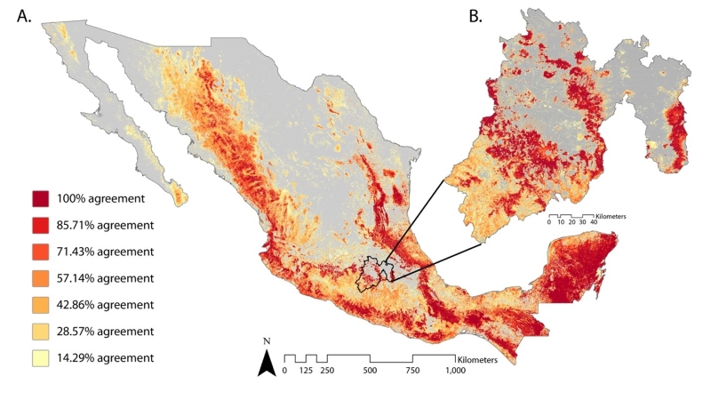
Satellite-Derived Forest Extent Likelihood Map for Mexico recent views
National Aeronautics and Space Administration —
This dataset provides a comparison of forest extent agreement from seven remote sensing-based products across Mexico. These satellite-derived products include... -
Federal
Arctic Boreal Annual Burned Area, Circumpolar Boreal Forest and Tundra, V2, 2002-2022 NGDA recent views
National Aeronautics and Space Administration —
This dataset provides annual cumulative end-of-season burned area in circumpolar boreal forests and tundra for the years 2002-2022. The data were generated using the... -
Federal
ABoVE: Modeled Top Cover by Plant Functional Type over Alaska and Yukon, 1985-2020 recent views
National Aeronautics and Space Administration —
This dataset contains data files of modeled top cover estimates by plant functional type (PFT) for the Arctic and Boreal Alaska and Yukon regions. Estimates are... -
Federal
Ground-Based Vegetation Community Photos, Toolik Lake Area, Alaska, 2014-2015 recent views
National Aeronautics and Space Administration —
This dataset contains 731 ground-based nadir vegetation community and ground surface photographs of selected field plots taken as ground reference data for vegetation... -
Federal
Multispectral Imagery, NDVI, and Terrain Models, Big Trail Lake, Fairbanks, AK, 2019 recent views
National Aeronautics and Space Administration —
This dataset provides multispectral reflectance imagery (green at 550 nm, red at 660 nm, red edge at 735 nm, and near-infrared at 790 nm), normalized difference... -
Federal
ABoVE: Characterization of Carbon Dynamics in Burned Forest Plots, NWT, Canada, 2014 recent views
National Aeronautics and Space Administration —
This dataset provides field data from boreal forests in the Northwest Territories (NWT), Canada, that were burned by wildfires in 2014. During fieldwork in 2015, 211... -
Federal
Aboveground Biomass Density for High Latitude Forests from ICESat-2, 2020 recent views
National Aeronautics and Space Administration —
This dataset provides estimates of Aboveground dry woody Biomass Density (AGBD) for high northern latitude forests at a 30-m spatial resolution. It is designed both... -
Federal
ABoVE: Wolf Denning Phenology and Reproductive Success, Alaska and Canada, 2000-2017 NGDA recent views
National Aeronautics and Space Administration —
This dataset provides annual gray wolf (Canis lupus) denning spatial information and timing, associated climatic and phenologic metrics, and reproductive success... -
Federal
Tundra Plant Reflectance, CO2 Exchange, PAM Fluorometry, and Pigments, AK, 2001-2002 recent views
National Aeronautics and Space Administration —
This dataset provides measurements at tundra plots collected near Utqiagvik and Atqasuk, AK, including visible-near infrared spectral reflectance, chamber gas... -
Federal
Burned and Unburned Field Site Data, Noatak, Seward, and North Slope, AK, 2016-2018 recent views
National Aeronautics and Space Administration —
This dataset includes field measurements from unburned and burned 10 m x 10 m and 1 m x 1 m plots in the Noatak, Seward, and North Slope regions of the Alaskan tundra... -
Federal
Arctic Vegetation Plots at Umiat, North Slope, Alaska, 1951 recent views
National Aeronautics and Space Administration —
This data set provides vegetation cover and plot data collected during the periods of July and August, 1951, from 51 stands (areas of homogeneous vegetation... -
Federal
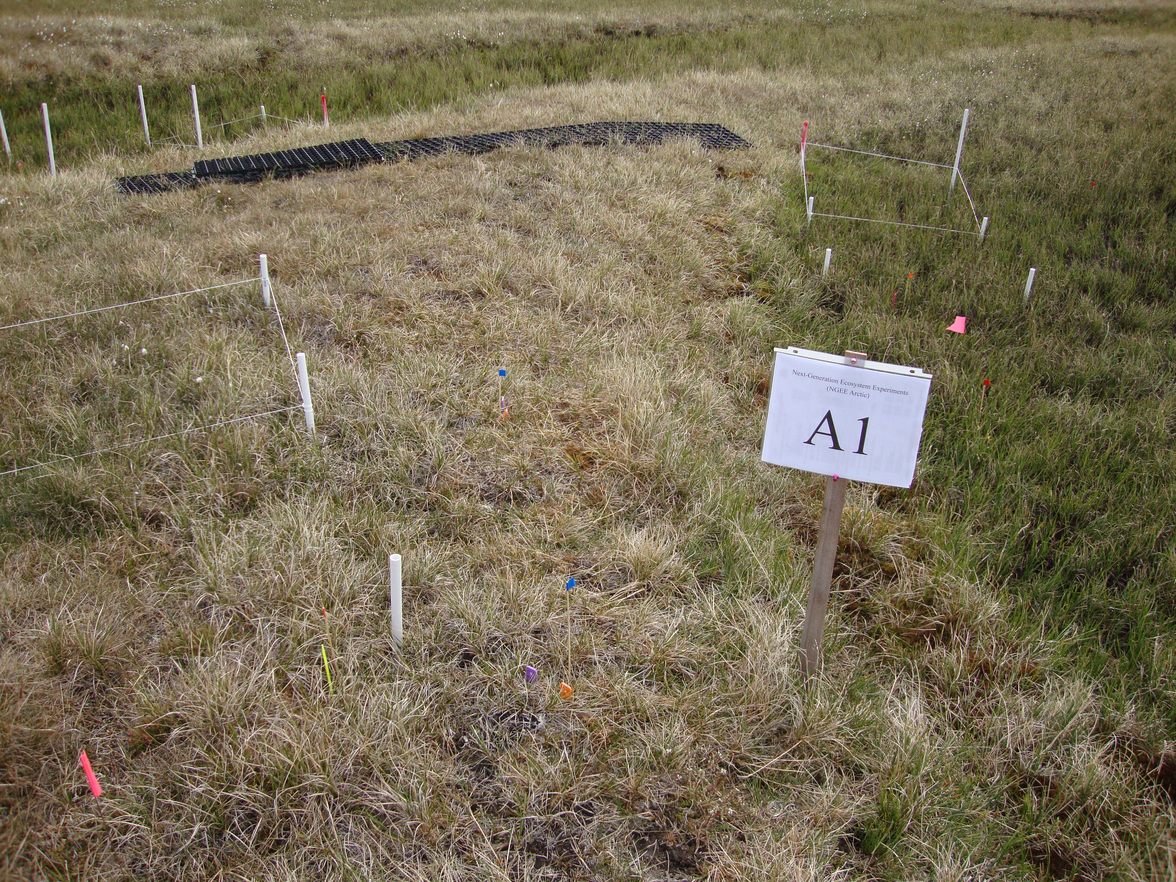
Arctic Vegetation Plots for NGEE-Arctic at Barrow, Alaska, 2012 recent views
National Aeronautics and Space Administration —
This data set provides vegetation cover and environmental plot data collected on the Barrow Environmental Observatory (BEO), Barrow, Alaska in 2012. Forty-eight 1 x 1...

Official websites use .gov
A
.gov website belongs to an official government
organization in the United States.
Secure .gov websites use HTTPS
A
lock (
) or https:// means you’ve safely connected to
the .gov website. Share sensitive information only on official,
secure websites.