
-
Federal
Global Forest Ecosystem Structure and Function Data For Carbon Balance Research recent views
National Aeronautics and Space Administration —
A comprehensive global database has been assembled to quantify CO2 fluxes and pathways across different levels of integration (from photosynthesis up to net ecosystem... -
Federal
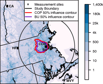
CO2 Observations, Modeled Emissions, and NAM-HYSPLIT Footprints, Boston MA, 2013-2014 recent views
National Aeronautics and Space Administration —
This dataset reports continuous atmospheric measurements of CO2 from two receptor sites and three boundary sites in and around Boston, Massachusetts, USA, that were... -
Federal
ATom: Comprehensive Aerosol Properties, 2016-2018, Version 2 recent views
National Aeronautics and Space Administration —
This dataset contains comprehensive measurements of aerosol microphysical, chemical, and optical properties derived for both dry and ambient conditions from in situ... -
Federal
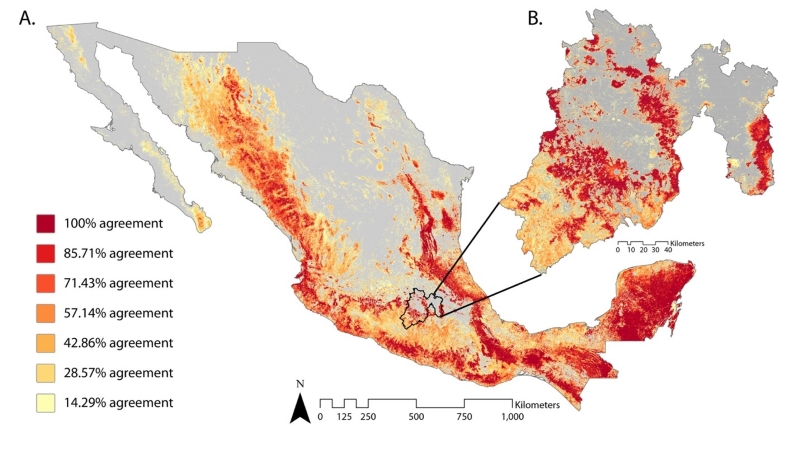
Satellite-Derived Forest Extent Likelihood Map for Mexico recent views
National Aeronautics and Space Administration —
This dataset provides a comparison of forest extent agreement from seven remote sensing-based products across Mexico. These satellite-derived products include... -
Federal
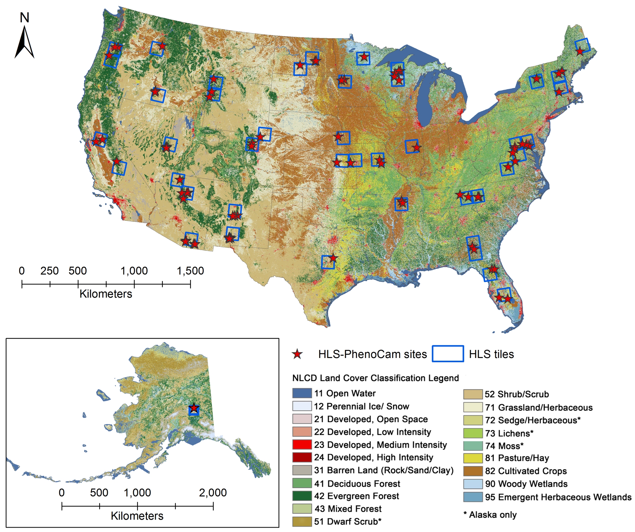
Phenology derived from Satellite Data and PhenoCam across CONUS and Alaska, 2019-2020 recent views
National Aeronautics and Space Administration —
This dataset provides a reference of land surface phenology (LSP) at 30-m pixels for 78 regions of 10 x 10 km2 across a wide range of ecological and climatic regions... -
Federal
SHIFT: AVIRIS-NG Full-Resolution True Color Images recent views
National Aeronautics and Space Administration —
This dataset holds full-resolution 3-band (true color) imagery acquired by NASA's Airborne Visible / Infrared Imaging Spectrometer-Next Generation (AVIRIS-NG)... -
Federal
A Global Database of Gas Fluxes from Soils after Rewetting or Thawing, Version 1.0 recent views
National Aeronautics and Space Administration —
This database contains information compiled from published studies on gas flux from soil following rewetting or thawing. The resulting database includes 222 field and... -
Federal
Sources of Methane Emissions (Vista-CA), State of California, USA recent views
National Aeronautics and Space Administration —
This dataset provides spatial data products with identified and organized locations of potential methane (CH4) emitting facilities and infrastructure spanning the... -
Federal
PalEON: Terrestrial Ecosystem Model Drivers for the Northeastern U.S., 0850-2010 recent views
National Aeronautics and Space Administration —
This dataset from the PalEON Ecosystem Model Intercomparison Project (PEMIP) provides harmonized regional environmental and meteorological drivers at a resolution of... -
Federal
MASTER: Airborne Science, western US, June, 1999 recent views
National Aeronautics and Space Administration —
This dataset includes Level 1B (L1B) data products from the MODIS/ASTER Airborne Simulator (MASTER) instrument. The spectral data were collected during 10 flights... -
Federal
CARVE: L1 Spectral Radiances from Airborne FTS, Alaska, 2012-2015 recent views
National Aeronautics and Space Administration —
This data set contains Level 1 spectral radiance data collected using the Fourier Transform Spectrometer (FTS) during airborne campaigns over the Alaskan and Canadian... -
Federal
Pre-ABoVE: Particle Trajectories for WRF-STILT Model, Barrow, AK, 1982-2011 recent views
National Aeronautics and Space Administration —
This dataset provides Stochastic Time-Inverted Lagrangian Transport model outputs for receptors located at the NOAA Barrow Alaska Observatory for 12 selected years... -
Federal
ACT-America: L2 In Situ Atmospheric CO2, CO, CH4, and O3 Concentrations, Eastern USA recent views
National Aeronautics and Space Administration —
This dataset provides atmospheric carbon dioxide (CO2), carbon monoxide (CO), methane (CH4), water vapor (H2O), and ozone (O3) concentrations collected during... -
Federal
SAFARI 2000 Derived Soil Properties, 0.5-Deg (ISRIC-WISE) recent views
National Aeronautics and Space Administration —
The data set consists of a southern African subset of the ISRIC-WISE global data set of derived soil properties. The World Inventory of Soil Emission Potentials... -
Federal
Delta-X: Real-Time Kinematic Elevation Measurements for Coastal Wetlands, LA, 2021 recent views
National Aeronautics and Space Administration —
This dataset provides real-time kinematic (RTK) GPS elevation measurements, along with horizontal and vertical precision errors, obtained along transects near... -
Federal
AirMOSS: L1 S-0 Polarimetric Data from AirMOSS P-band SAR, Chamela, Mexico, 2012-2015 recent views
National Aeronautics and Space Administration —
This data set provides level 1 (L1) polarimetric radar backscattering coefficient (sigma-0), multilook complex, polarimetrically calibrated, and georeferenced data... -
Federal
Pre-ABoVE: Gridded Footprints from WRF-STILT Model, Barrow, Alaska, 1982-2011 recent views
National Aeronautics and Space Administration —
This dataset provides Stochastic Time-Inverted Lagrangian Transport model outputs for receptors located at the NOAA Barrow Alaska Observatory for 12 selected years... -
Federal
ABoVE: Distribution Maps of Wildland Fire Fuel Components across Alaskan Tundra, 2015 recent views
National Aeronautics and Space Administration —
This dataset provides maps of the distribution of three major wildland fire fuel types at 30 m spatial resolution covering the Alaskan arctic tundra, circa 2015. The... -
Federal
CARVE: L1 In-situ Carbon and CH4 Flux and Meteorology at EC Towers, Alaska, 2011-2015 recent views
National Aeronautics and Space Administration —
This data set provides ground in situ flux and meteorological science data from fixed instruments at three eddy covariance tower sites located in the Alaskan Arctic...

Official websites use .gov
A
.gov website belongs to an official government
organization in the United States.
Secure .gov websites use HTTPS
A
lock (
) or https:// means you’ve safely connected to
the .gov website. Share sensitive information only on official,
secure websites.