
-
Federal
GLDAS Noah Land Surface Model L4 monthly 0.25 x 0.25 degree V2.1 (GLDAS_NOAH025_M) at GES DISC recent views
National Aeronautics and Space Administration —
NASA Global Land Data Assimilation System Version 2 (GLDAS-2) has three components: GLDAS-2.0, GLDAS-2.1, and GLDAS-2.2. GLDAS-2.0 is forced entirely with the... -
Federal
GLDAS Catchment Land Surface Model L4 daily 0.25 x 0.25 degree V2.0 (GLDAS_CLSM025_D) at GES DISC recent views
National Aeronautics and Space Administration —
NASA Global Land Data Assimilation System Version 2 (GLDAS-2) has three components: GLDAS-2.0, GLDAS-2.1, and GLDAS-2.2. GLDAS-2.0 is forced entirely with the... -
Federal
MERRA-2 tavg1_2d_slv_Nx: 2d,1-Hourly,Time-Averaged,Single-Level,Assimilation,Single-Level Diagnostics 0.625 x 0.5 degree V5.12.4 (M2T1NXSLV) at GES DISC recent views
National Aeronautics and Space Administration —
M2T1NXSLV (or tavg1_2d_slv_Nx) is an hourly time-averaged 2-dimensional data collection in Modern-Era Retrospective analysis for Research and Applications version 2... -
Federal
GLDAS Catchment Land Surface Model L4 daily 0.25 x 0.25 degree GRACE-DA1 V2.2 (GLDAS_CLSM025_DA1_D) at GES DISC recent views
National Aeronautics and Space Administration —
NASA Global Land Data Assimilation System Version 2 (GLDAS-2) has three components: GLDAS-2.0, GLDAS-2.1, and GLDAS-2.2. GLDAS-2.0 is forced entirely with the... -
Federal
MERRA-2 instU_3d_asm_Np: 3d,diurnal,Instantaneous,Pressure-Level,Assimilation,Assimilated Meteorological Fields 0.625 x 0.5 degree V5.12.4 (M2IUNPASM) at GES DISC recent views
National Aeronautics and Space Administration —
M2IUNPASM (or instU_3d_asm_Np) is an instantaneous 3-dimensional monthly diurnal means data collection in Modern-Era Retrospective analysis for Research and... -
Federal
MERRA-2 inst6_3d_ana_Np: 3d,6-Hourly,Instantaneous,Pressure-Level,Analysis,Analyzed Meteorological Fields 0.625 x 0.5 degree V5.12.4 (M2I6NPANA) at GES DISC recent views
National Aeronautics and Space Administration —
M2I6NPANA (or inst6_3d_ana_Np) is an instantaneous 3-dimensional 6-hourly data collection in Modern-Era Retrospective analysis for Research and Applications version 2... -
Federal
Goddard Satellite-Based Surface Turbulent Fluxes, 0.25 x 0.25 deg, Daily Grid F14 V3 (GSSTF_F14) at GES DISC recent views
National Aeronautics and Space Administration —
These data are part of the Goddard Satellite-based Surface Turbulent Fluxes Version 3 (GSSTF3) Dataset recently produced through a MEaSURES funded project led by Dr.... -
Federal
Goddard Satellite-Based Surface Turbulent Fluxes, 0.25 x 0.25 deg, Daily Grid F10 V3 (GSSTF_F10) at GES DISC recent views
National Aeronautics and Space Administration —
These data are part of the Goddard Satellite-based Surface Turbulent Fluxes Version 3 (GSSTF3) Dataset recently produced through a MEaSURES funded project led by Dr.... -
Federal
FLDAS Noah Land Surface Model L4 Global Monthly 0.1 x 0.1 degree (GDAS and CHIRPS-PRELIM) V001 (FLDAS_NOAH01_CP_GL_M) at GES DISC recent views
National Aeronautics and Space Administration —
This dataset contains a series of land surface parameters simulated from the Noah 3.6.1 model in the Famine Early Warning Systems Network (FEWS NET) Land Data... -
Federal
GLDAS Catchment Land Surface Model L4 monthly 1.0 x 1.0 degree V2.1 (GLDAS_CLSM10_M) at GES DISC recent views
National Aeronautics and Space Administration —
NASA Global Land Data Assimilation System Version 2 (GLDAS-2) has three components: GLDAS-2.0, GLDAS-2.1, and GLDAS-2.2. GLDAS-2.0 is forced entirely with the... -
Federal
GLDAS Noah Land Surface Model L4 3 hourly 0.25 x 0.25 degree V2.1 (GLDAS_NOAH025_3H) at GES DISC recent views
National Aeronautics and Space Administration —
NASA Global Land Data Assimilation System Version 2 (GLDAS-2) has three components: GLDAS-2.0, GLDAS-2.1, and GLDAS-2.2. GLDAS-2.0 is forced entirely with the... -
Federal
NCEP/DOE Reanalysis II, for GSSTF, 0.25 x 0.25 deg, Daily Grid V3 (GSSTF_NCEP) at GES DISC recent views
National Aeronautics and Space Administration —
These data are the Goddard Satellite-based Surface Turbulent Fluxes Version 3 Dataset recently produced through a MEaSURES funded project led by Dr. Chung-Lin Shie... -
Federal
GLDAS Noah Land Surface Model L4 monthly 0.25 x 0.25 degree V2.0 (GLDAS_NOAH025_M) at GES DISC recent views
National Aeronautics and Space Administration —
NASA Global Land Data Assimilation System Version 2 (GLDAS-2) has three components: GLDAS-2.0, GLDAS-2.1, and GLDAS-2.2. GLDAS-2.0 is forced entirely with the... -
Federal
NLDAS Secondary Forcing Data L4 Hourly 0.125 x 0.125 degree V2.0 (NLDAS_FORB0125_H) at GES DISC recent views
National Aeronautics and Space Administration —
This data set contains the secondary forcing hourly data "File B" for Phase 2 of the North American Land Data Assimilation System (NLDAS-2). The data are in 1/8th... -
Federal
NLDAS Primary Forcing Data L4 Monthly Climatology 0.125 x 0.125 degree V2.0 (NLDAS_FORA0125_MC) at GES DISC recent views
National Aeronautics and Space Administration —
This data set contains the monthly climatology data of the primary forcing data for Phase 2 of the North American Land Data Assimilation System (NLDAS-2). The data... -
Federal
FLDAS Noah Land Surface Model L4 Global Monthly 0.1 x 0.1 degree (MERRA-2 and CHIRPS) V001 (FLDAS_NOAH01_C_GL_M) at GES DISC recent views
National Aeronautics and Space Administration —
This dataset contains a series of land surface parameters simulated from the Noah 3.6.1 model in the Famine Early Warning Systems Network (FEWS NET) Land Data... -
Federal
LBA-ECO CD-01 Meteorological Data, Tapajos and Amazon Rivers, Santarem, Brazil: 2001 recent views
National Aeronautics and Space Administration —
This data set contains meteorological data collected around the confluence of the Tapajos River with the Amazon River in the Amazon Basin near Santarem, Brazil, in... -
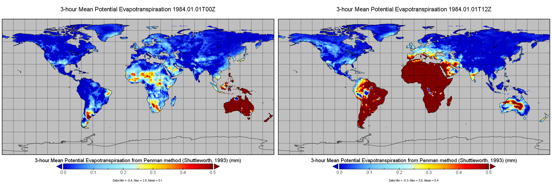
Federal
RM-OBS/PU Potential Evapotranspiration and Supporting Forcing L4 3-hourly 0.25x0.25 degree V001 (PET_PU_3H025) at GES DISC recent views
National Aeronautics and Space Administration —
The Princeton University MEaSUREs Potential Evapotranspiration (PET) dataset provides a set of estimates of PET based on near surface meteorology and surface... -
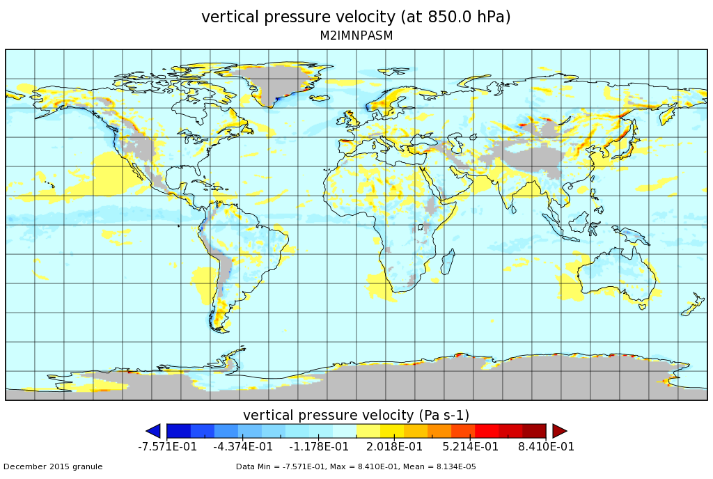
Federal
MERRA-2 instM_3d_asm_Np: 3d,Monthly mean,Instantaneous,Pressure-Level,Assimilation,Assimilated Meteorological Fields 0.625 x 0.5 degree V5.12.4 (M2IMNPASM) at GES DISC recent views
National Aeronautics and Space Administration —
M2IMNPASM (or instM_3d_asm_Np) is an instantaneous 3-dimensional monthly mean data collection in Modern-Era Retrospective analysis for Research and Applications... -
Federal
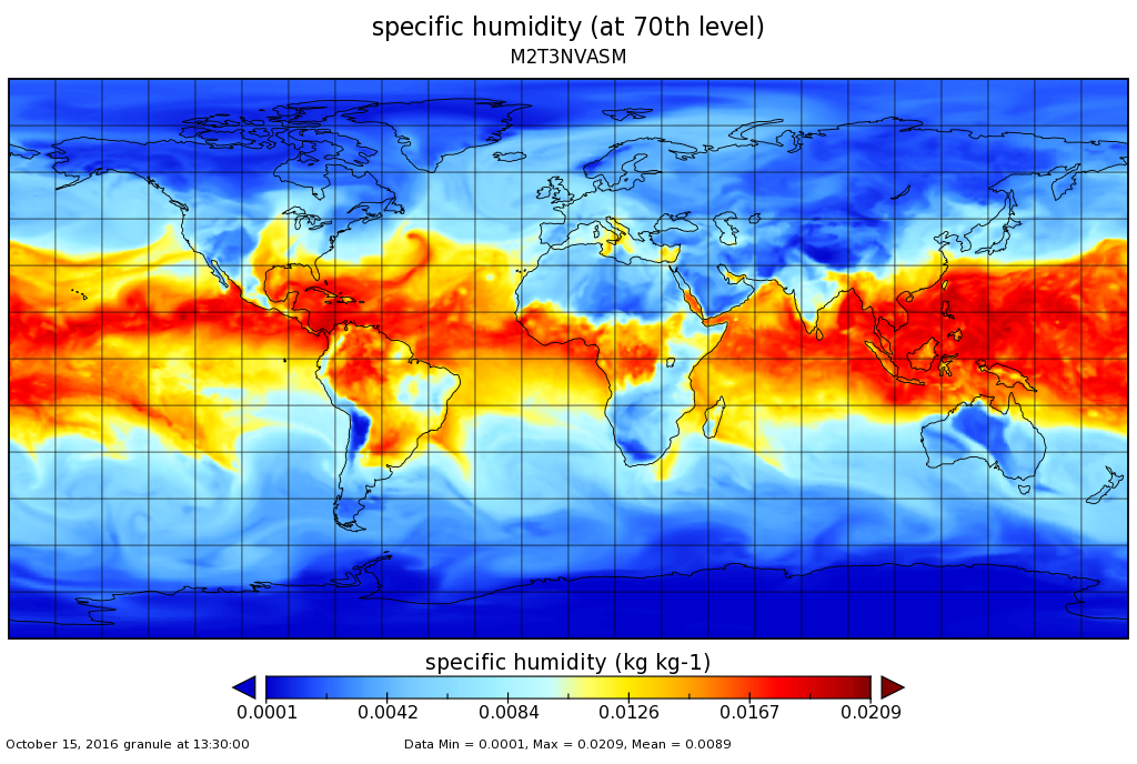
MERRA-2 tavg3_3d_asm_Nv: 3d,3-Hourly,Time-Averaged,Model-Level,Assimilation,Assimilated Meteorological Fields 0.625 x 0.5 degree V5.12.4 (M2T3NVASM) at GES DISC recent views
National Aeronautics and Space Administration —
M2T3NVASM (or tavg3_3d_asm_Nv) is a 3-dimensional 3-hourly time averaged data collection in Modern-Era Retrospective analysis for Research and Applications version 2...

Official websites use .gov
A
.gov website belongs to an official government
organization in the United States.
Secure .gov websites use HTTPS
A
lock (
) or https:// means you’ve safely connected to
the .gov website. Share sensitive information only on official,
secure websites.