
-
Federal
MLS/Aura Near-Real-Time L2 Ozone (O3) Mixing Ratio V005 (ML2O3_NRT) at GES DISC recent views
National Aeronautics and Space Administration —
ML2O3_NRT is the EOS Aura Microwave Limb Sounder (MLS) Near-Real-Time (NRT) product for ozone (O3). This product contains O3 profiles derived from the 240 GHz region.... -
Federal
Sounder SIPS: Suomi NPP CrIMSS Level 3 Specific Quality Control Gridded Daily SiFSAP V2 (SNDRSNIML3SDSFSP) at GES DISC recent views
National Aeronautics and Space Administration —
The SIFSAP (Single Field-of-View Sounder Atmospheric Products) algorithm provides retrieval for each sounder Field of View (FOV), therefore, it has 3-times higher... -
Federal
Daily and Annual PM2.5, O3, and NO2 Concentrations at ZIP Codes for the Contiguous U.S., 2000-2016, v1.0 recent views
National Aeronautics and Space Administration —
The Daily and Annual PM2.5, O3, and NO2 Concentrations at ZIP Codes for the Contiguous U.S., 2000-2016, v1.0 data set contains daily and annual concentration... -
Federal
Global Maps of Atmospheric Nitrogen Deposition, 1860, 1993, and 2050 recent views
National Aeronautics and Space Administration —
This data set provides global gridded estimates of atmospheric deposition of total inorganic nitrogen (N), NHx (NH3 and NH4+), and NOy (all oxidized forms of nitrogen... -
Federal
Annual PM2.5 Concentrations for Countries and Urban Areas, 1998-2016 NGDA recent views
National Aeronautics and Space Administration —
The Annual PM2.5 Concentrations for Countries and Urban Areas, 1998-2016, consists of mean concentrations of particulate matter (PM2.5) for countries and urban areas.... -
Federal
Daily and Annual NO2 Concentrations for the Contiguous United States, 1-km Grids, v1 (2000 - 2016) recent views
National Aeronautics and Space Administration —
The Daily and Annual NO2 Concentrations for the Contiguous United States, 1-km Grids, v1 (2000-2016) data set contains daily predictions of Nitrogen Dioxide (NO2)... -
Federal
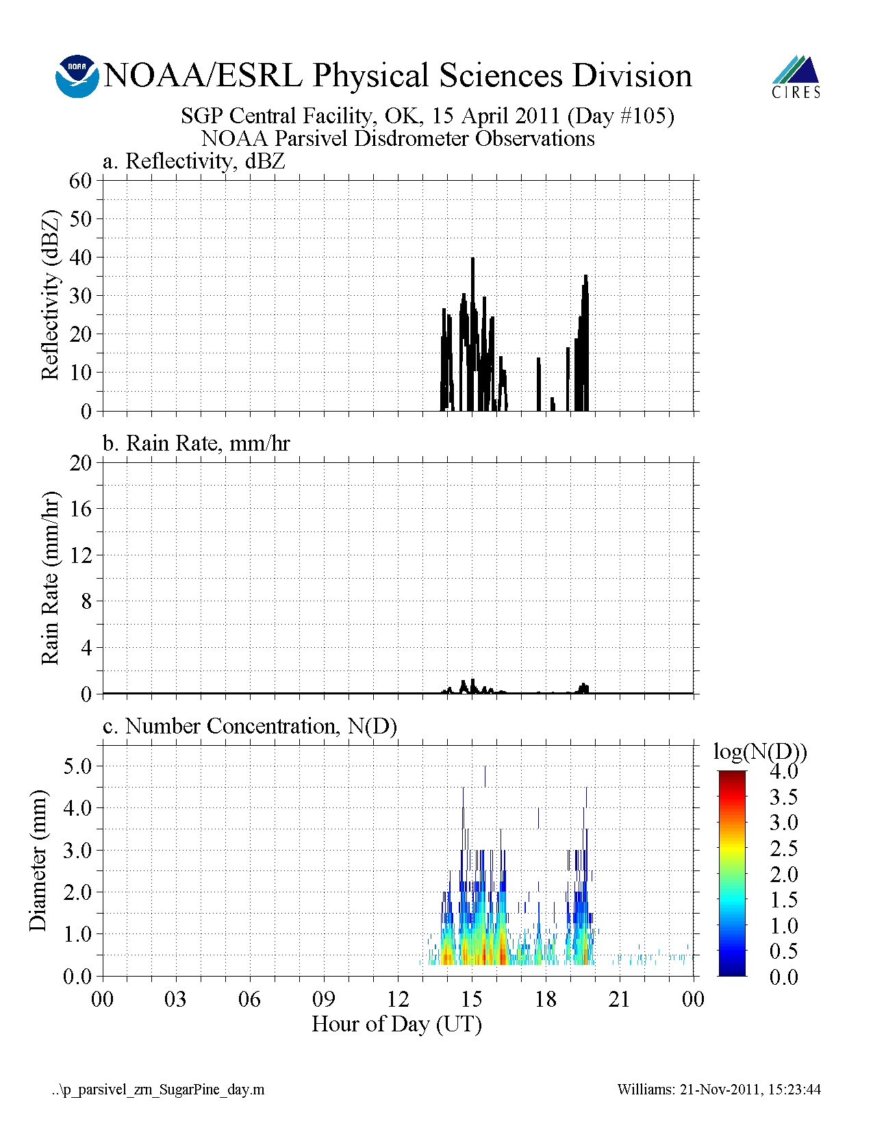
GPM GROUND VALIDATION NOAA PARSIVEL MC3E V1 recent views
National Aeronautics and Space Administration —
The GPM Ground Validation NOAA Parsivel MC3E dataset was collected in central Oklahoma during the Midlatitude Continental Convective Clouds Experiment (MC3E) from... -
Federal
OCO-2 Level 1A collated, parsed, science or calibration data V11 (OCO2_L1aIn_Sample) at GES DISC recent views
National Aeronautics and Space Administration —
Version 11 is the current version of the data set. Older versions will no longer be available and are superseded by Version 11. The Orbiting Carbon Observatory is the... -
Federal
SPURS-2 Passive Accoustic Listener (PAL) data from ARGO float deployments during the E. Tropical Pacific field campaign recent views
National Aeronautics and Space Administration —
The SPURS (Salinity Processes in the Upper Ocean Regional Study) project is a NASA-funded oceanographic process study and associated field program that aim to... -
Federal
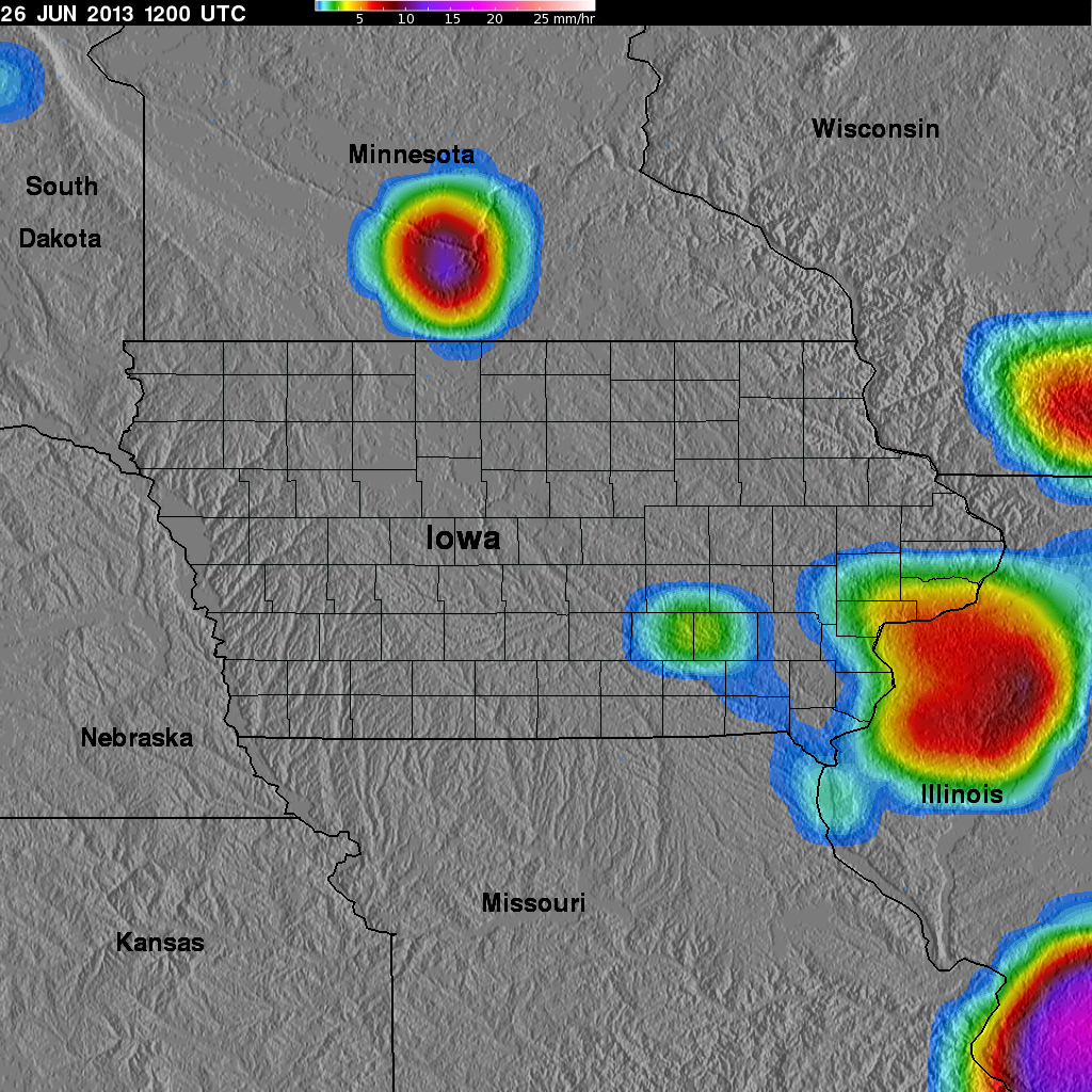
GPM Ground Validation TRMM Multi-satellite Precipitation Analysis (TMPA) IFloodS V7 recent views
National Aeronautics and Space Administration —
The GPM Ground Validation TRMM Multi-satellite Precipitation Analysis (TMPA) IFloodS dataset is a subset of the TMPA 3B42RT gridded precipitation real-time product... -
Federal
CAR SKUKUZA BRDF Measurements L1 V2 (CAR_SKUKUZA_BRDF) at GES DISC recent views
National Aeronautics and Space Administration —
CAR mission Skukuza measured bidirectional reflection functions over different natural surfaces and ecosystems in southern Africa. The measurements were conducted to... -
Federal
CAR ECO3D BRDF Measurements V2 (CAR_ECO3D_BRDF) at GES DISC recent views
National Aeronautics and Space Administration —
This study provide critical measurements on 3-dimensional structure of vegetation, which is important for quantifying the amount of carbon stored in biomass. It... -
Federal
ECOSTRESS Cloud Mask Daily L2 Global 70m V001 recent views
National Aeronautics and Space Administration —
The ECOsystem Spaceborne Thermal Radiometer Experiment on Space Station (ECOSTRESS) mission measures the temperature of plants to better understand how much water... -
Federal
Daily and Annual PM2.5 Concentrations for the Contiguous United States, 1-km Grids, v1 (2000 - 2016) recent views
National Aeronautics and Space Administration —
The Daily and Annual PM2.5 Concentrations for the Contiguous United States, 1-km Grids, v1 (2000 - 2016) data set includes predictions of PM2.5 concentrations in grid... -
Federal
Global 3-Year Running Mean Ground-Level Nitrogen Dioxide (NO2) Grids from GOME, SCIAMACHY and GOME-2 recent views
National Aeronautics and Space Administration —
The Global 3-Year Running Mean Ground-Level Nitrogen Dioxide (NO2) Grids from GOME, SCIAMACHY and GOME-2 represent a series of three-year running mean grids... -
Federal
Methane Emissions from Dairy Sources (Vista-CA), State of California, USA, 2019 recent views
National Aeronautics and Space Administration —
This dataset provides estimates of methane (CH4) emissions from dairies in California at a resolution of 0.1 degrees (~ 10 km x 10 km) for the year 2019. The mapped... -
Federal
OCO-2 Level 1B calibrated, geolocated calibration spectra V11.2 (OCO2_L1B_Calibration) at GES DISC recent views
National Aeronautics and Space Administration —
Version 11.2 is the current version of the data set. Older versions will no longer be available and are superseded by Version 11.2. The Orbiting Carbon Observatory is... -
Federal
A Global Database of Gas Fluxes from Soils after Rewetting or Thawing, Version 1.0 recent views
National Aeronautics and Space Administration —
This database contains information compiled from published studies on gas flux from soil following rewetting or thawing. The resulting database includes 222 field and... -
Federal
OCO-3 Level 2 geolocated XCO2 retrievals results, physical model, Retrospective Processing V10r (OCO3_L2_Standard) at GES DISC recent views
National Aeronautics and Space Administration —
Version 10r is the current version of the data set. Older versions will no longer be available and are superseded by Version 10r. The Orbiting Carbon Observatory -3... -
Federal
GRIP HURRICANE IMAGING RADIOMETER (HIRAD) V1 recent views
National Aeronautics and Space Administration —
The GRIP Hurricane Imaging Radiometer (HIRAD) V1 dataset contains measurements of brightness temperature taken at 4, 5, 6 and 6.6 GHz, as well as MERRA 2 m wind speed...

Official websites use .gov
A
.gov website belongs to an official government
organization in the United States.
Secure .gov websites use HTTPS
A
lock (
) or https:// means you’ve safely connected to
the .gov website. Share sensitive information only on official,
secure websites.