
-
Federal
GLDAS Catchment Land Surface Model L4 daily 0.25 x 0.25 degree GRACE-DA1 V2.2 (GLDAS_CLSM025_DA1_D_EP) at GES DISC recent views
National Aeronautics and Space Administration —
NASA Global Land Data Assimilation System Version 2 (GLDAS-2) has three components: GLDAS-2.0, GLDAS-2.1, and GLDAS-2.2. GLDAS-2.0 is forced entirely with the... -
Federal
First ISCCP Regional Experiment (FIRE) Atlantic Stratocumulus Transition Experiment (ASTEX) PSU Malcolm Baldridge Data recent views
National Aeronautics and Space Administration —
The First ISCCP Regional Experiments have been designed to improve data products and cloud/radiation parameterizations used in general circulation models (GCMs).... -
Federal
NARSTO SOS99 Nashville WP-3D Orion Air Chemistry Data recent views
National Aeronautics and Space Administration —
NARSTO_SOS99NASH_WP3D_CHEMISTRY_DATA is the North American Research Strategy for Tropospheric Ozone (NARSTO) SOS99 Nashville WP-3D Orion Air Chemistry Data product.... -
Federal
SCOAPE R/V Point Sur Data recent views
National Aeronautics and Space Administration —
SCOAPE_RVPointSur_Data is the data collected from instruments onboard the University of Southern Mississippi’s Research Vessel (R/V) Point Sur during the Satellite... -
Federal
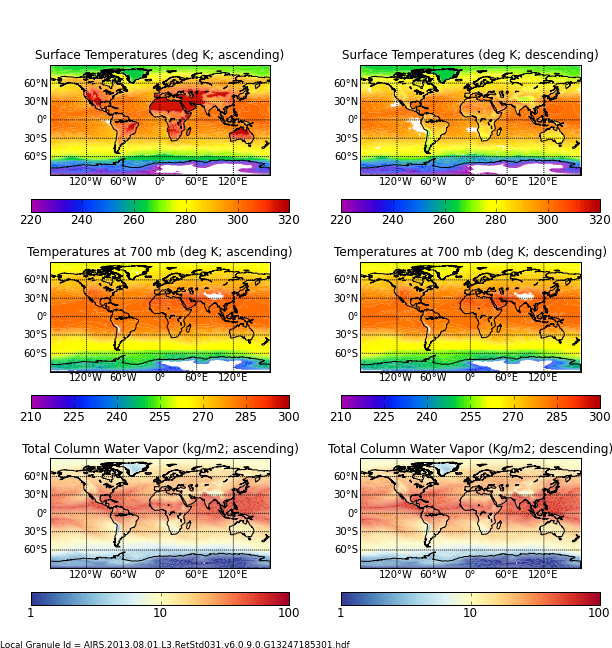
AIRS/Aqua L3 Monthly Standard Physical Retrieval (AIRS+AMSU) 1 degree x 1 degree V006 (AIRX3STM) at GES DISC recent views
National Aeronautics and Space Administration —
The Atmospheric Infrared Sounder (AIRS) is a grating spectrometer (R = 1200) aboard the second Earth Observing System (EOS) polar-orbiting platform, EOS Aqua. In... -
Federal
Sounder SIPS: JPSS-1 CrIS Level 3 Comprehensive Quality Control Gridded Monthly CLIMCAPS V2 (SNDRJ1IML3CMCCP) at GES DISC recent views
National Aeronautics and Space Administration —
WARNING: To users of the derived product “co_mmr_midtrop” (carbon monoxide mass mixing ratio to dry air [kg/kg] at ~500 hPa). This variable has a significant bias due... -
Federal
DISCOVER-AQ California Deployment Porterville Ground Site Data recent views
National Aeronautics and Space Administration —
DISCOVERAQ_California_Ground_Porterville_Data contains data collected at the Porterville ground site during the California (San Joaquin Valley) deployment of NASA's... -
Federal
TOVS GLA 5 DAY GRIDS from NOAA-10 V01 (TOVSA5NG) at GES DISC recent views
National Aeronautics and Space Administration —
This dataset (TOVSA5NG) contains the TIROS Operational Vertical Sounder (TOVS) level 3 geophysical parameters derived using data from NOAA-10 and the physical... -
Federal
CERES and GEO-Enhanced TOA, Within-Atmosphere and Surface Fluxes, Clouds and Aerosols Monthly-Averaged 1-Hourly Terra-NPP Edition1A NGDA recent views
National Aeronautics and Space Administration —
CER_SYN1deg-MHour_Terra-NPP_Edition1A is the Clouds and the Earth's Radiant Energy System (CERES) and geostationary (GEO)-Enhanced Top-of-Atmosphere (TOA), Within-... -
Federal
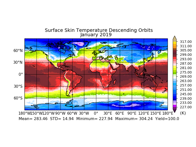
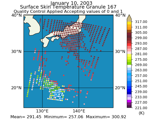
Aqua/AIRS L2 Standard Physical Retrieval (AIRS+AMSU+HSB) V7.0 at GES DISC recent views
National Aeronautics and Space Administration —
The Atmospheric Infrared Sounder (AIRS) is a grating spectrometer (R = 1200) aboard the second Earth Observing System (EOS) polar-orbiting platform, EOS Aqua. In... -
Federal
GLDAS Catchment Land Surface Model L4 daily 0.25 x 0.25 degree GRACE-DA1 V2.2 (GLDAS_CLSM025_DA1_D) at GES DISC recent views
National Aeronautics and Space Administration —
NASA Global Land Data Assimilation System Version 2 (GLDAS-2) has three components: GLDAS-2.0, GLDAS-2.1, and GLDAS-2.2. GLDAS-2.0 is forced entirely with the... -
Federal
SAGE III/ISS L1B Monthly Solar Event Transmission Data (NetCDF) V053 recent views
National Aeronautics and Space Administration —
g3btmnc_53 is the Stratospheric Aerosol and Gas Experiment III (SAGE III) on the International Space Station (ISS) (SAGE III/ISS) Level 1 Monthly Solar Event Species... -
Federal
DISCOVER-AQ Texas Deployment Smith Point Ground Site Data recent views
National Aeronautics and Space Administration —
DISCOVERAQ_Texas_Ground_SmithPoint_Data contains data collected at the Smith Point ground site during the Texas (Houston) deployment of NASA's DISCOVER-AQ field... -
Federal
AMAZE-08 Aerosol Characterization and Meteorological Data, Central Amazon Basin: 2008 recent views
National Aeronautics and Space Administration —
This data set provides measurements from the Amazonian Aerosol Characterization Experiment (AMAZE-08) carried out during the wet season from February 4 to March 21,... -
Federal
High Altitude MMIC Sounding Radiometer (HAMSR) CPEX-AW V1 recent views
National Aeronautics and Space Administration —
The High Altitude MMIC Sounding Radiometer (HAMSR) CPEX-AW dataset includes measurements gathered by the HAMSR instrument during the Convective Processes Experiment –... -
Federal
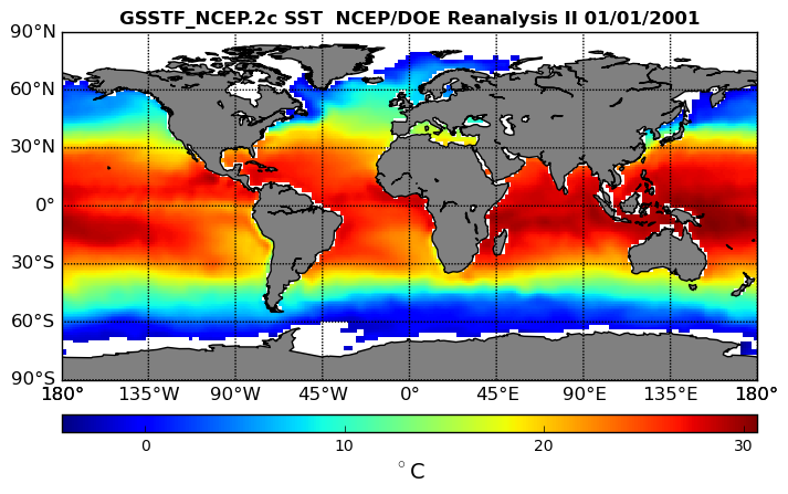
NCEP/DOE Reanalysis II in HDF-EOS5, for GSSTF2c, 1x1 deg Daily grid V2c (GSSTF_NCEP) at GES DISC recent views
National Aeronautics and Space Administration —
These data are the Goddard Satellite-based Surface Turbulent Fluxes Version-2c (GSSTF2c) Dataset recently produced through a MEaSURES funded project led by Dr. Chung-... -
Federal
Eddy Corr. Surface Flux: GSFC (FIFE) recent views
National Aeronautics and Space Administration —
Surface flux measurements by eddy correlation technique during FIFE -
Federal
Bowen Ratio Surface Flux: USGS (FIFE) recent views
National Aeronautics and Space Administration —
Surface flux measurements by Bowen Ratio technique during FIFE -
Federal
Bowen Ratio Surface Flux: GSFC (FIFE) recent views
National Aeronautics and Space Administration —
Surface flux measurements by Bowen Ratio technique during FIFE -
Federal
ABoVE: CO2 and CH4 Fluxes and Meteorology at Flux Tower Sites, Alaska, 2015-2017 recent views
National Aeronautics and Space Administration —
This dataset provides CO2 and CH4 fluxes and meteorological parameters from five eddy covariance (EC) tower sites located at Barrow (three sites), Atqasuk (ATQ) and...

Official websites use .gov
A
.gov website belongs to an official government
organization in the United States.
Secure .gov websites use HTTPS
A
lock (
) or https:// means you’ve safely connected to
the .gov website. Share sensitive information only on official,
secure websites.