
-
Federal
SMEX05 Meteorological Network Data: Iowa, Version 1
National Aeronautics and Space Administration —
Notice to Data Users: The documentation for this data set was provided solely by the Principal Investigator(s) and was not further developed, thoroughly reviewed, or... -
Federal
ISLSCP II ECMWF Near-Surface Meteorology Parameters
National Aeronautics and Space Administration —
This data set for the ISLSCP Initiative II data collection provides meteorology data with fixed, monthly, monthly-6-hourly, 6-hourly, and 3-hourly temporal... -
Federal
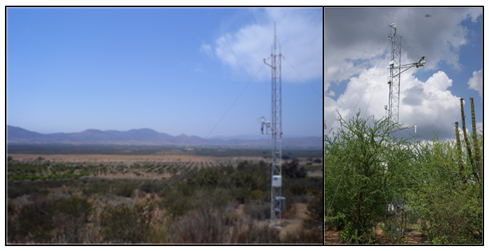
CMS: Evapotranspiration and Meteorology, Water-Limited Shrublands, Mexico, 2008-2010
National Aeronautics and Space Administration —
This data set provides daily average observations for evapotranspiration (measured and gap-filled), precipitation, net radiation, soil water content, air temperature,... -
Federal
Soil temperatures at South Royalton, Vermont, USA, Version 1
National Aeronautics and Space Administration —
This data set presents half-hourly measurements of soil temperatures at depths of 0 to 60 cm, together with meteorological data (air temperature, precipitation,... -
Federal
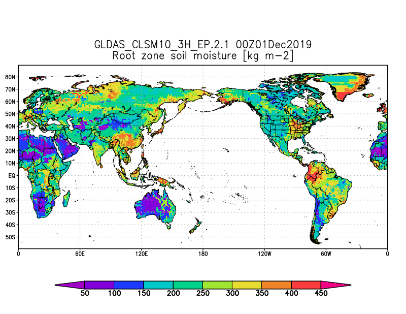
GLDAS Catchment Land Surface Model L4 3 hourly 1.0 x 1.0 degree Early Product V2.1 (GLDAS_CLSM10_3H_EP) at GES DISC
National Aeronautics and Space Administration —
NASA Global Land Data Assimilation System Version 2 (GLDAS-2) has three components: GLDAS-2.0, GLDAS-2.1, and GLDAS-2.2. GLDAS-2.0 is forced entirely with the... -
Federal
SAFARI 2000 Meteorological and Flux Tower Measurements in Maun, Botswana, 2000
National Aeronautics and Space Administration —
To investigate potential contributions of savanna ecosystems to the Earth's carbon balance, an eddy covariance system was used to measure the seasonal variation in... -
Federal
CLPX NOAA FSL Rapid Update Cycle 20 km (RUC-20) Dataset, Version 1
National Aeronautics and Space Administration —
The Rapid Update Cycle analysis/model system at a 20-km horizontal resolution (RUC20) provides short-range numerical weather guidance for general forecasting, as well... -
Federal
LINKAGES: An Individual-based Forest Ecosystem Biogeochemistry Model
National Aeronautics and Space Administration —
This model product contains the source codes for version 1 of the individual-based forest ecosystem biogeochemistry model LINKAGES and two subsequent versions as well... -
Federal
FLUXNET Research Network Site Characteristics, Investigators, and Bibliography, 2016
National Aeronautics and Space Administration —
FLUXNET is a global network of micrometeorological tower sites that use eddy covariance methods to measure the exchanges of carbon dioxide, water vapor, and energy... -
Federal
GPM Ground Validation Environment Canada (EC) Weather Station XET C3VP V1
National Aeronautics and Space Administration —
The GPM Ground Validation Environment Canada (EC) Weather Station XET C3VP dataset consists of surface meteorological data collected at the Environment Canada (EC)... -
Federal
FLUXNET Canada Research Network - Canadian Carbon Program Data Collection, 1993-2014
National Aeronautics and Space Administration —
FLUXNET Canada is a Fluxnet research network comprised of the Fluxnet-Canada Research Network (FCRN) and the Canadian Carbon Program (CCP) operating from 1993 through... -
Federal
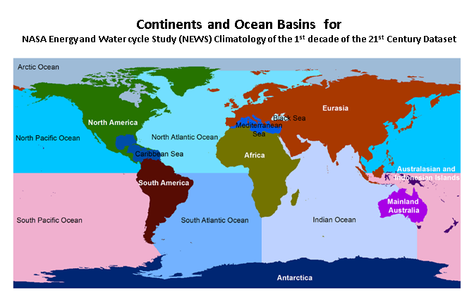
NASA Energy and Water cycle Study (NEWS) Monthly Climatology of the 1st decade of the 21st Century V1.0 (NEWS_WEB_MCLIM) at GES DISC
National Aeronautics and Space Administration —
NASA Energy and Water cycle Study (NEWS) Climatology of the 1st decade of the 21st Century Dataset summarizes the original observationally-based mean fluxes of water... -
Federal
GLDAS Noah Land Surface Model L4 monthly 1.0 x 1.0 degree V2.1 (GLDAS_NOAH10_M) at GES DISC
National Aeronautics and Space Administration —
NASA Global Land Data Assimilation System Version 2 (GLDAS-2) has three components: GLDAS-2.0, GLDAS-2.1, and GLDAS-2.2. GLDAS-2.0 is forced entirely with the... -
Federal
Eddy Corr. Surface Flux: UNL (FIFE)
National Aeronautics and Space Administration —
Latent & sensible heat flux by eddy correlation & aerodynamic characterization of vegetation -
Federal
NLDAS Mosaic Land Surface Model L4 Monthly Climatology 0.125 x 0.125 degree V002 (NLDAS_MOS0125_MC) at GES DISC
National Aeronautics and Space Administration —
This monthly climatology data set contains a series of land surface parameters simulated from the Mosaic land-surface model (LSM) for Phase 2 of the North American... -
Federal
Eddy Corr. Surface Flux: GSFC (FIFE)
National Aeronautics and Space Administration —
Surface flux measurements by eddy correlation technique during FIFE -
Federal
Eddy Corr. Surface Flux: UK (FIFE)
National Aeronautics and Space Administration —
Areal average evapotranspiration by measuring & modeling surface controls -
Federal
MERRA-2 tavgM_2d_lnd_Nx: 2d,Monthly mean,Time-Averaged,Single-Level,Assimilation,Land Surface Diagnostics 0.625 x 0.5 degree V5.12.4 (M2TMNXLND) at GES DISC
National Aeronautics and Space Administration —
M2TMNXLND (or tavgM_2d_lnd_Nx) is a time-averaged 2-dimensional monthly mean data collection in Modern-Era Retrospective analysis for Research and Applications... -
Federal
Bowen Ratio Surface Flux: USGS (FIFE)
National Aeronautics and Space Administration —
Surface flux measurements by Bowen Ratio technique during FIFE -
Federal
Bowen Ratio Surface Flux: GSFC (FIFE)
National Aeronautics and Space Administration —
Surface flux measurements by Bowen Ratio technique during FIFE

Official websites use .gov
A
.gov website belongs to an official government
organization in the United States.
Secure .gov websites use HTTPS
A
lock (
) or https:// means you’ve safely connected to
the .gov website. Share sensitive information only on official,
secure websites.