
-
Federal
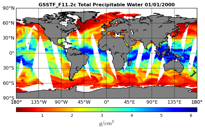
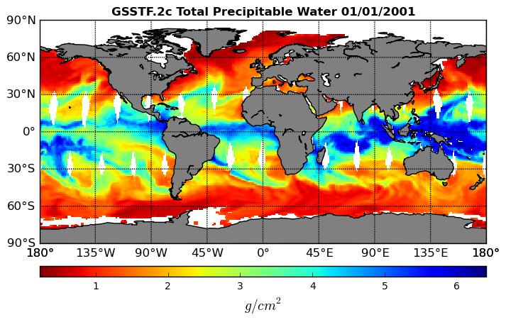
Goddard Satellite-Based Surface Turbulent Fluxes, 1x1 deg Daily Grid, Satellite F11 V2c (GSSTF_F11) at GES DISC recent views
National Aeronautics and Space Administration —
These data are part of the Goddard Satellite-based Surface Turbulent Fluxes Version-2c (GSSTF 2c) Dataset recently produced through a MEaSURES funded project led by... -
Federal
GEOS-5 FP-IT 3D Time-Averaged Single-Level Diagnostics Geo-Colocated to OMI/Aura VIS 1-Orbit L2 Swath 13x24km V4 (OMVFPSLV) at GES DISC recent views
National Aeronautics and Space Administration —
The GEOS-5 FP-IT 3D Time-Averaged Single-Level Diagnostics Geo-Colocated to OMI/Aura VIS 1-Orbit L2 Swath 13x24km (OMVFPSLV) provides selected parameters from GEOS-5... -
Federal
GLDAS Noah Land Surface Model L4 3 hourly 1.0 x 1.0 degree V2.1 (GLDAS_NOAH10_3H) at GES DISC recent views
National Aeronautics and Space Administration —
NASA Global Land Data Assimilation System Version 2 (GLDAS-2) has three components: GLDAS-2.0, GLDAS-2.1, and GLDAS-2.2. GLDAS-2.0 is forced entirely with the... -
Federal
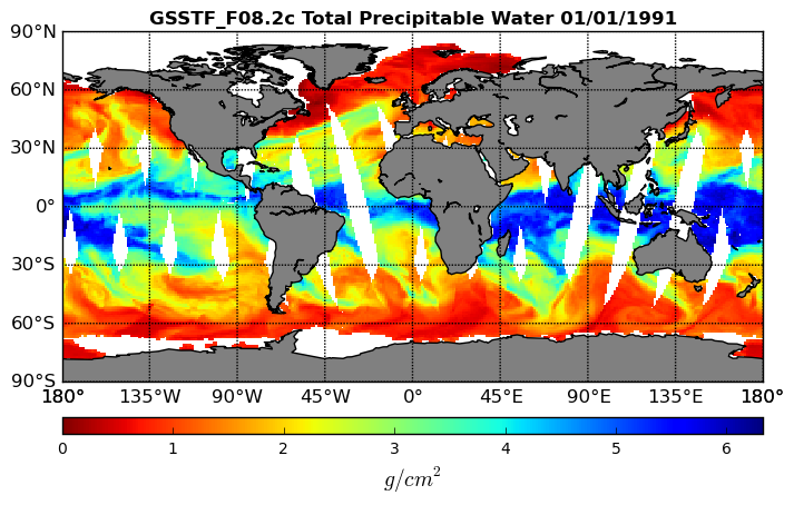
Goddard Satellite-Based Surface Turbulent Fluxes, 1x1 deg Daily Grid, Satellite F08 V2c (GSSTF_F08) at GES DISC recent views
National Aeronautics and Space Administration —
These data are part of the Goddard Satellite-based Surface Turbulent Fluxes Version-2c (GSSTF 2c) Dataset recently produced through a MEaSURES funded project led by... -
Federal
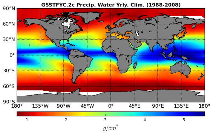
Goddard Satellite-Based Surface Turbulent Fluxes Climatology, 0.25 x 0.25 deg, Yearly Grid V3 (GSSTFYC) at GES DISC recent views
National Aeronautics and Space Administration —
These data are the Goddard Satellite-based Surface Turbulent Fluxes Version-3 Dataset recently produced through a MEaSUREs funded project led by Dr. Chung-Lin Shie... -
Federal
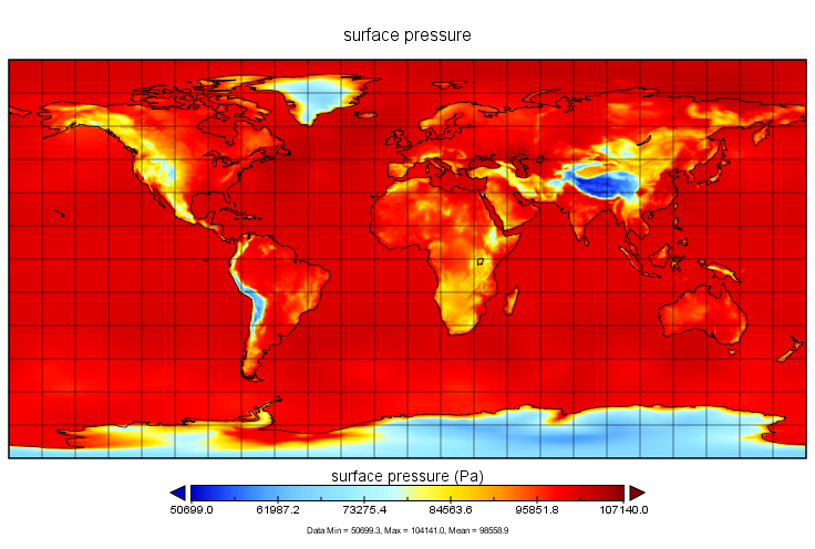
MERRA-2 inst6_3d_ana_Nv: 3d,6-Hourly,Instantaneous,Model-Level,Analysis,Analyzed Meteorological Fields 0.625 x 0.5 degree V5.12.4 (M2I6NVANA) at GES DISC recent views
National Aeronautics and Space Administration —
M2I6NVANA (or inst6_3d_ana_Nv) is an instantaneous 3-dimensional 6-hourly data collection in Modern-Era Retrospective analysis for Research and Applications version 2... -
Federal
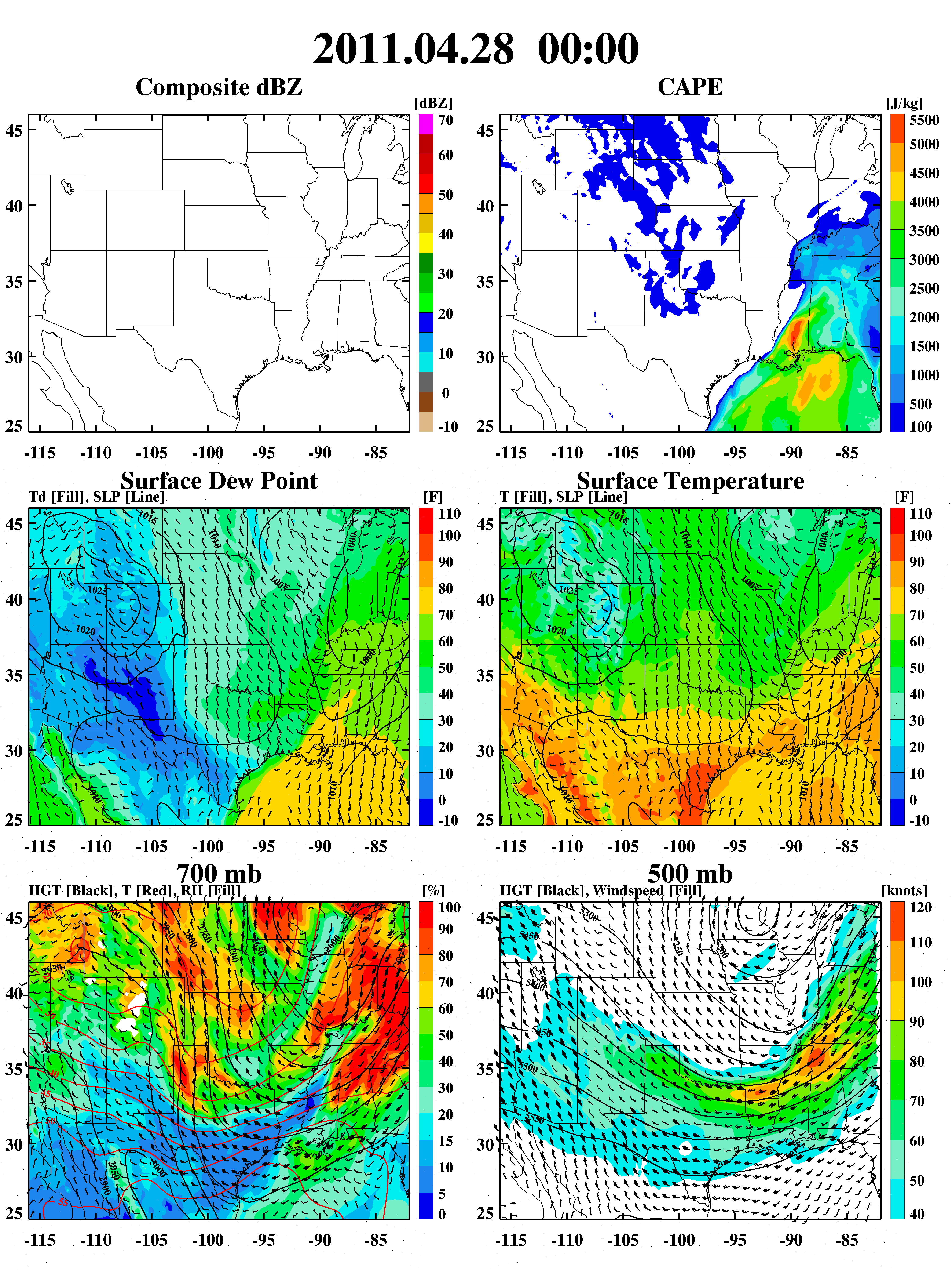
GPM Ground Validation Weather Research and Forecasting (WRF) Images MC3E V1 recent views
National Aeronautics and Space Administration —
The GPM Ground Validation Weather Research and Forecasting (WRF) Images MC3E dataset consists of browse only images showing radar reflectivity, radar echo top,... -
Federal
CERES A-Train Integrated CALIPSO, CloudSat, CERES, and MODIS (CCCM) Merged Release D2 NGDA recent views
National Aeronautics and Space Administration —
CER_CCCM_Aqua-FM3-MODIS-CAL-CS_RelD2 is Release D2 of a highly fused Level 2 data product that uses multiple satellites and instruments in the Afternoon Train or... -
Federal
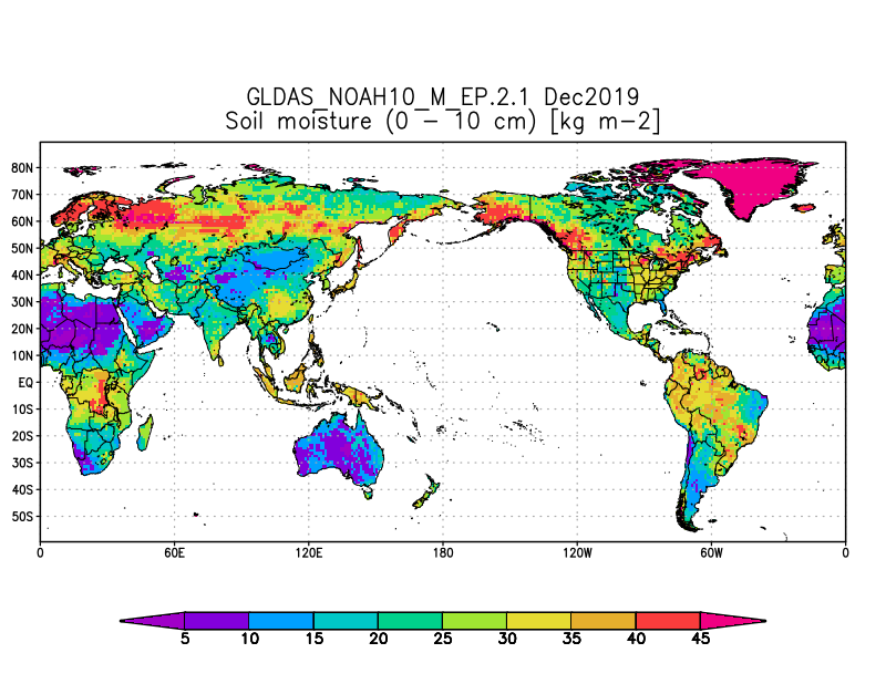
GLDAS Noah Land Surface Model L4 monthly 1.0 x 1.0 degree V2.1 (GLDAS_NOAH10_M) at GES DISC recent views
National Aeronautics and Space Administration —
NASA Global Land Data Assimilation System Version 2 (GLDAS-2) has three components: GLDAS-2.0, GLDAS-2.1, and GLDAS-2.2. GLDAS-2.0 is forced entirely with the... -
Federal
NLDAS Secondary Forcing Data L4 Monthly Climatology 0.125 x 0.125 degree V2.0 (NLDAS_FORB0125_MC) at GES DISC recent views
National Aeronautics and Space Administration —
This data set contains the monthly climatology (MC) data of the secondary forcing data for Phase 2 of the North American Land Data Assimilation System (NLDAS-2). The... -
Federal
WLDAS Noah-MP 3.6 Land Surface Model L4 Daily 0.01 degree x 0.01 degree Version D1.0 (WLDAS_NOAHMP001_DA1) at GES DISC recent views
National Aeronautics and Space Administration —
The Western Land Data Assimilation System (WLDAS), developed at Goddard Space Flight Center (GSFC) and funded by the NASA Western Water Applications Office, provides... -
Federal
NLDAS Primary Forcing Data L4 Monthly 0.125 x 0.125 degree V2.0 (NLDAS_FORA0125_M) at GES DISC recent views
National Aeronautics and Space Administration —
This data product contains the monthly primary forcing data "File A" for Phase 2 of the North American Land Data Assimilation System (NLDAS-2). The data are in 1/8th... -
Federal
MERRA-2 inst1_2d_lfo_Nx: 2d,1-Hourly,Instantaneous,Single-Level,Assimilation,Land Surface Forcings 0.625 x 0.5 degree V5.12.4 (M2I1NXLFO) at GES DISC recent views
National Aeronautics and Space Administration —
M2I1NXLFO (or inst1_2d_lfo_Nx) is an instantaneous 2-dimensional hourly data collection in Modern-Era Retrospective analysis for Research and Applications version 2... -
Federal
GLDAS Noah Land Surface Model L4 3 hourly 0.25 x 0.25 degree V2.0 (GLDAS_NOAH025_3H) at GES DISC recent views
National Aeronautics and Space Administration —
NASA Global Land Data Assimilation System Version 2 (GLDAS-2) has three components: GLDAS-2.0, GLDAS-2.1, and GLDAS-2.2. GLDAS-2.0 is forced entirely with the... -
Federal
GLDAS Noah Land Surface Model L4 monthly 1.0 x 1.0 degree V2.0 (GLDAS_NOAH10_M) at GES DISC recent views
National Aeronautics and Space Administration —
NASA Global Land Data Assimilation System Version 2 (GLDAS-2) has three components: GLDAS-2.0, GLDAS-2.1, and GLDAS-2.2. GLDAS-2.0 is forced entirely with the... -
Federal
GLDAS Noah Land Surface Model L4 monthly 0.25 x 0.25 degree Early Product V2.1 (GLDAS_NOAH025_M_EP) at GES DISC recent views
National Aeronautics and Space Administration —
NASA Global Land Data Assimilation System Version 2 (GLDAS-2) has three components: GLDAS-2.0, GLDAS-2.1, and GLDAS-2.2. GLDAS-2.0 is forced entirely with the... -
Federal
Goddard Satellite-Based Surface Turbulent Fluxes, 0.25 x 0.25 deg, Daily Grid V3 (GSSTF) at GES DISC recent views
National Aeronautics and Space Administration —
These data are the Goddard Satellite-based Surface Turbulent Fluxes Version-3 (GSSTF3) Dataset recently produced through a MEaSUREs funded project led by Dr. Chung-... -
Federal
Goddard Satellite-Based Surface Turbulent Fluxes, 1x1 deg Daily Grid, Satellite F13 V2c (GSSTF_F13) at GES DISC recent views
National Aeronautics and Space Administration —
These data are part of the Goddard Satellite-based Surface Turbulent Fluxes Version-2c (GSSTF 2c) Dataset recently produced through a MEaSURES funded project led by... -
Federal
GLDAS Noah Land Surface Model L4 monthly 1.0 x 1.0 degree Early Product V2.1 (GLDAS_NOAH10_M_EP) at GES DISC recent views
National Aeronautics and Space Administration —
NASA Global Land Data Assimilation System Version 2 (GLDAS-2) has three components: GLDAS-2.0, GLDAS-2.1, and GLDAS-2.2. GLDAS-2.0 is forced entirely with the... -
Federal
Land Surface Atmospheric Boundary Interaction Product L3 V1(LANDMET) at GES DISC recent views
National Aeronautics and Space Administration —
This product is a multi-variate data compilation that reconciles the variation scales of these multiple measurements from varies resources, merges and maps them into...

Official websites use .gov
A
.gov website belongs to an official government
organization in the United States.
Secure .gov websites use HTTPS
A
lock (
) or https:// means you’ve safely connected to
the .gov website. Share sensitive information only on official,
secure websites.