

16 datasets found for "Forts"
-
Federal
The Urban Energy-Water Nexus: Utility-Level Water Flows and Embedded Energy
Department of Energy —
There are limited open source data available for determining water production/treatment and required energy for cities across the United States. This database... -
Federal
Processed ADCP Current Depth Profiles, Flow Classification, and Power Law Parameters at Tidal Energy Sites
Department of Energy —
This dataset contains processed acoustic Doppler current profiler (ADCP) measurements from twenty energetic tidal energy sites in the United States, Scotland, and New... -
Federal
Tularosa Basin Play Fairway Analysis: Partial Basin and Range Heat and Zones of Critical Stress Maps
Department of Energy —
Interpolated maps of heat flow, temperature gradient, and quartz geothermometers are included as TIF files. Zones of critical stress map is also included as a TIF... -
Federal
Tularosa Basin Play Fairway Analysis: Raw MT Data for the McGregor Range, Fort Bliss, New Mexico
Department of Energy —
This is a zipped file containing raw magnetotelluric (MT) data collected as part of the Phase 2 Tularosa Basin geothermal play fairway analysis project in New Mexico.... -
Federal
Economic Impact of Permitting Timelines on Produced Geothermal Power
Department of Energy —
Despite having a large geothermal power potential in the United States, only a small fraction has been developed for power generation. Various barriers, including... -
Federal
Tularosa Basin Play Fairway Analysis: Modeled MT Resistivity Data for the McGregor Range, New Mexico
Department of Energy —
This is the inversion resistivity data from a magnetotelluric survey done as part of Phase 2 Tularosa Basin, New Mexico, geothermal play fairway analysis. The data... -
Federal
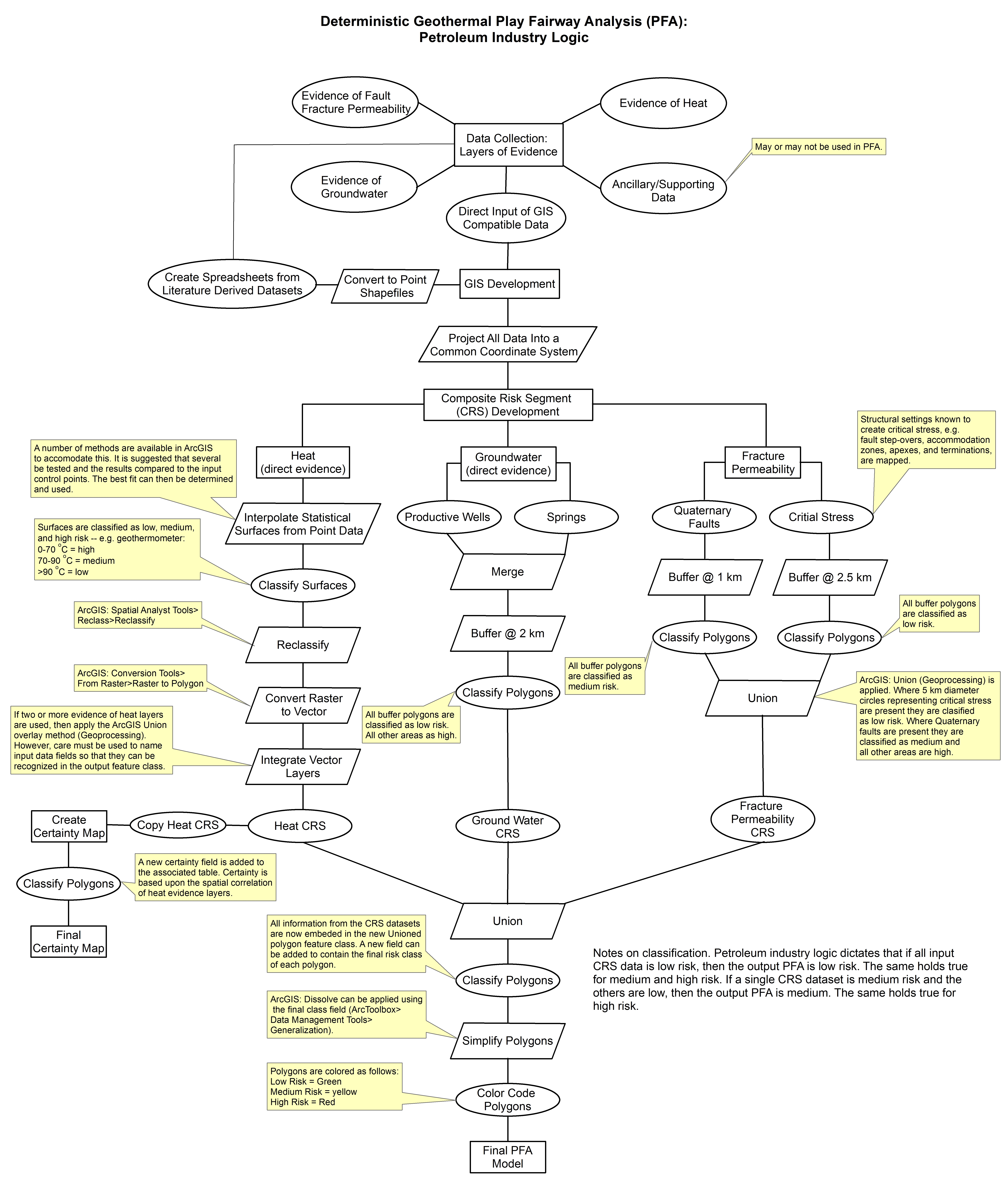
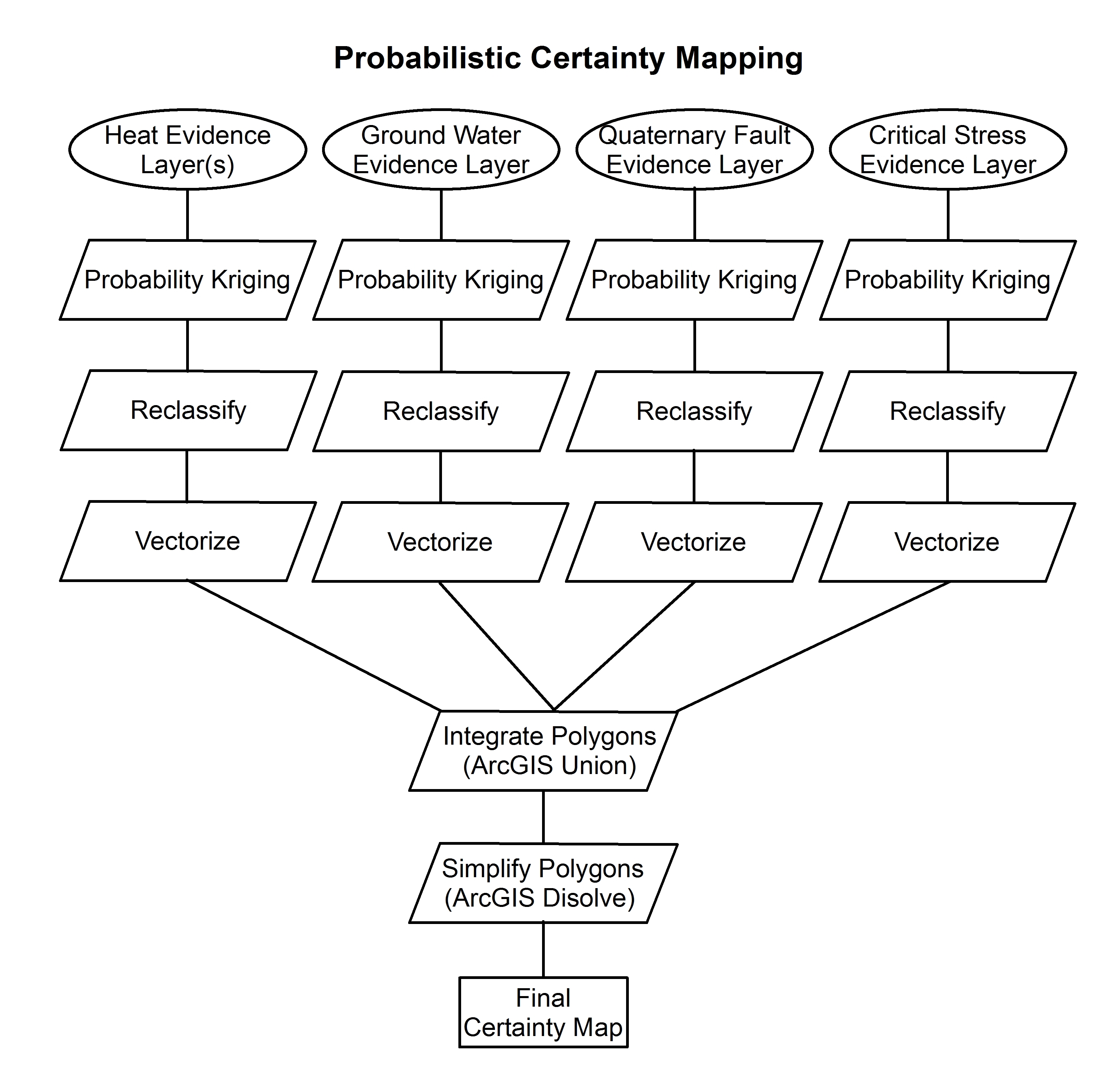
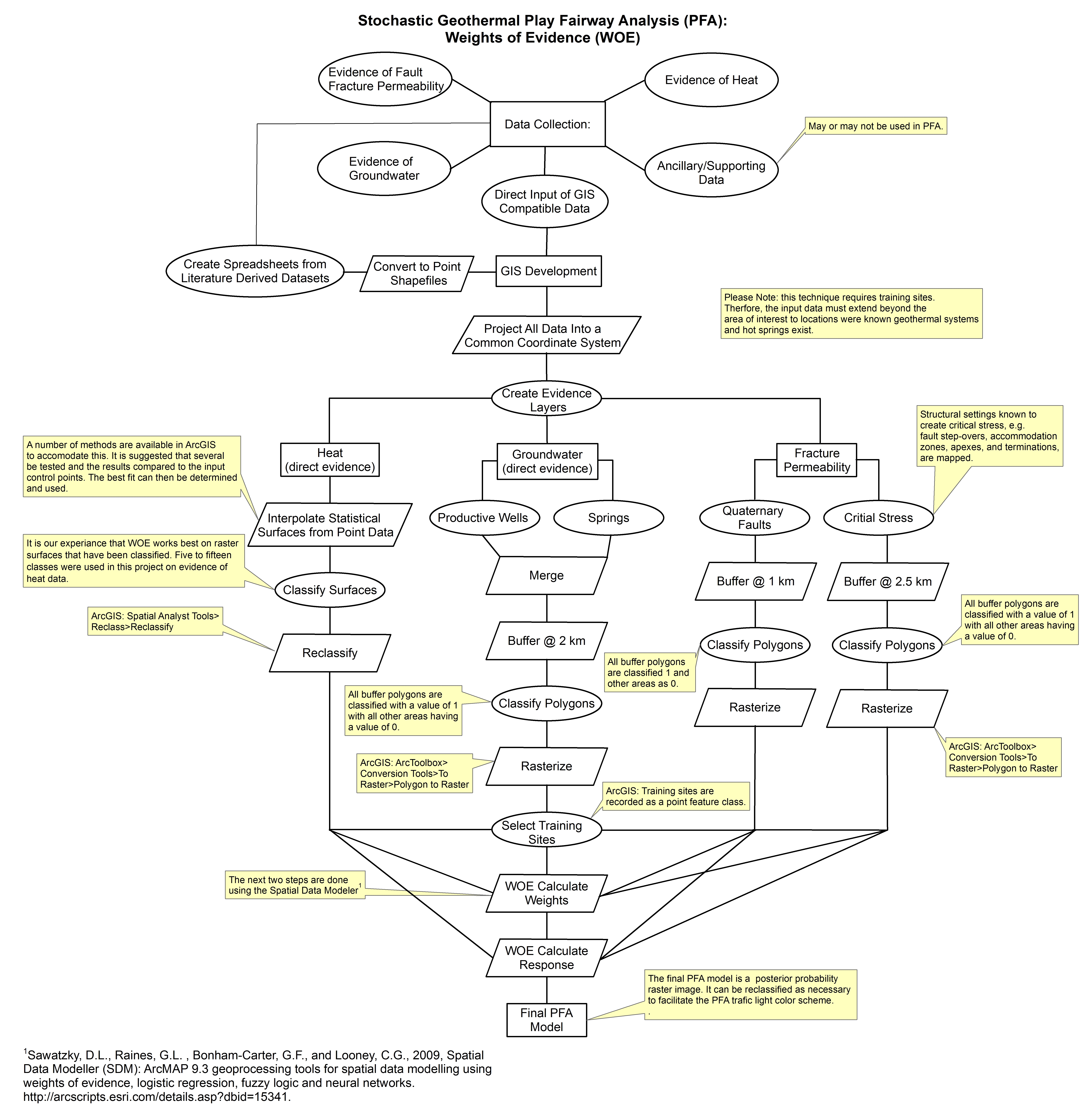
Tularosa Basin Play Fairway Analysis: Methodology Flow Charts
Department of Energy —
These images show the comprehensive methodology used for creation of a Play Fairway Analysis to explore the geothermal resource potential of the Tularosa Basin, New... -
Federal
Utah FORGE: Temperature Contours at 200 m
Department of Energy —
The individual shapefiles in this dataset delineate estimated temperature contours (20, 40, 60, and 80 deg C) at a depth of 200 m in the Milford, Utah FORGE area.... -
Federal
Fort Bliss Geothermal Area Data: Temperature Profile, Logs, Schematic Model and Cross Section
Department of Energy —
This dataset contains a variety of data about the Fort Bliss geothermal area, part of the southern portion of the Tularosa Basin, New Mexico. The dataset contains... -
Federal
Tularosa Basin Play Fairway Analysis: Pleistocene Lake Otero
Department of Energy —
This submission includes a geotiff of the geographic extent of Pleistocene Lake Otero; which was used as apart of the groundwater composite risk segment in a Tularosa... -
Federal
Maps, Models and Data from Southeastern Great Basin PFA
Department of Energy —
This submission includes composite risk segment models in raster format for permeability, heat of the earth, and MT, as well as the final PFA model of geothermal... -
Federal
Gravity Data from Cove Fort and Dog Valley, Utah Play Fairway Analysis
Department of Energy —
This is a zipped archive containing an ArcGIS shapefile and a text file containing gravity data covering the Cove Fort and Dog Valley areas in central Utah. Part of... -
Federal
Play Fairway Analysis Retrospective GeoRePORTs
Department of Energy —
NREL, as part of the Play Fairway Analysis (PFA) Retrospective and with assistance from PFA PIs, completed GeoRePORTs for the sites identified in Phases 1&2 of... -
Federal
Structural Inventory of Great Basin Geothermal Systems and Definition of Favorable Structural Settings
Department of Energy —
Structural controls of 426 geothermal systems in the Great Basin region including western Nevada, central Nevada, northwestern Nevada, northeastern Nevada, east-...
16 datasets found for "Forts"