
Search datasets
-
The Mountain Home area is characterized by high heat flow and temperature gradient. Temperature data are available from 18 boreholes with depths equal to or greater than 200 m, 5 of which have...
Search relevance: 1.00 | Views last month: 3 | Catalog Last Checked: March 23, 2026 at 09:40 PM -
This is the regional dataset compilation for the INnovative Geothermal Exploration through Novel Investigations Of Undiscovered Systems (INGENIOUS) project. The primary goal of this project is to...
Search relevance: 1.00 | Views last month: 3 | Catalog Last Checked: March 23, 2026 at 09:41 PM -
This dataset contain raw data files in kmz files (Google Earth georeference format). These files include volcanic vent locations and age, the distribution of fine-grained lacustrine sediments...
Search relevance: 1.00 | Views last month: 1 | Catalog Last Checked: March 23, 2026 at 09:39 PM -
This is an updated and simplified version of the New Mexico heat flow data already on the NGDS that was used for Play Fairway analysis.
Search relevance: 1.00 | Views last month: 0 | Catalog Last Checked: March 23, 2026 at 09:39 PM -
Photos of core samples from Lanai Island. During the third phase of the Hawaii Play Fairway project, further exploration involved drilling a groundwater well in Lanai's Palawai Basin and...
Search relevance: 1.00 | Views last month: 0 | Catalog Last Checked: March 23, 2026 at 09:41 PM -
This presents the results of Phase 1 of the Snake River Plain Play Fairway Analysis project, along with a proposed work for Phase 2. No new data were collected, but we list data sources for our...
Search relevance: 1.00 | Views last month: 0 | Catalog Last Checked: March 23, 2026 at 09:41 PM -
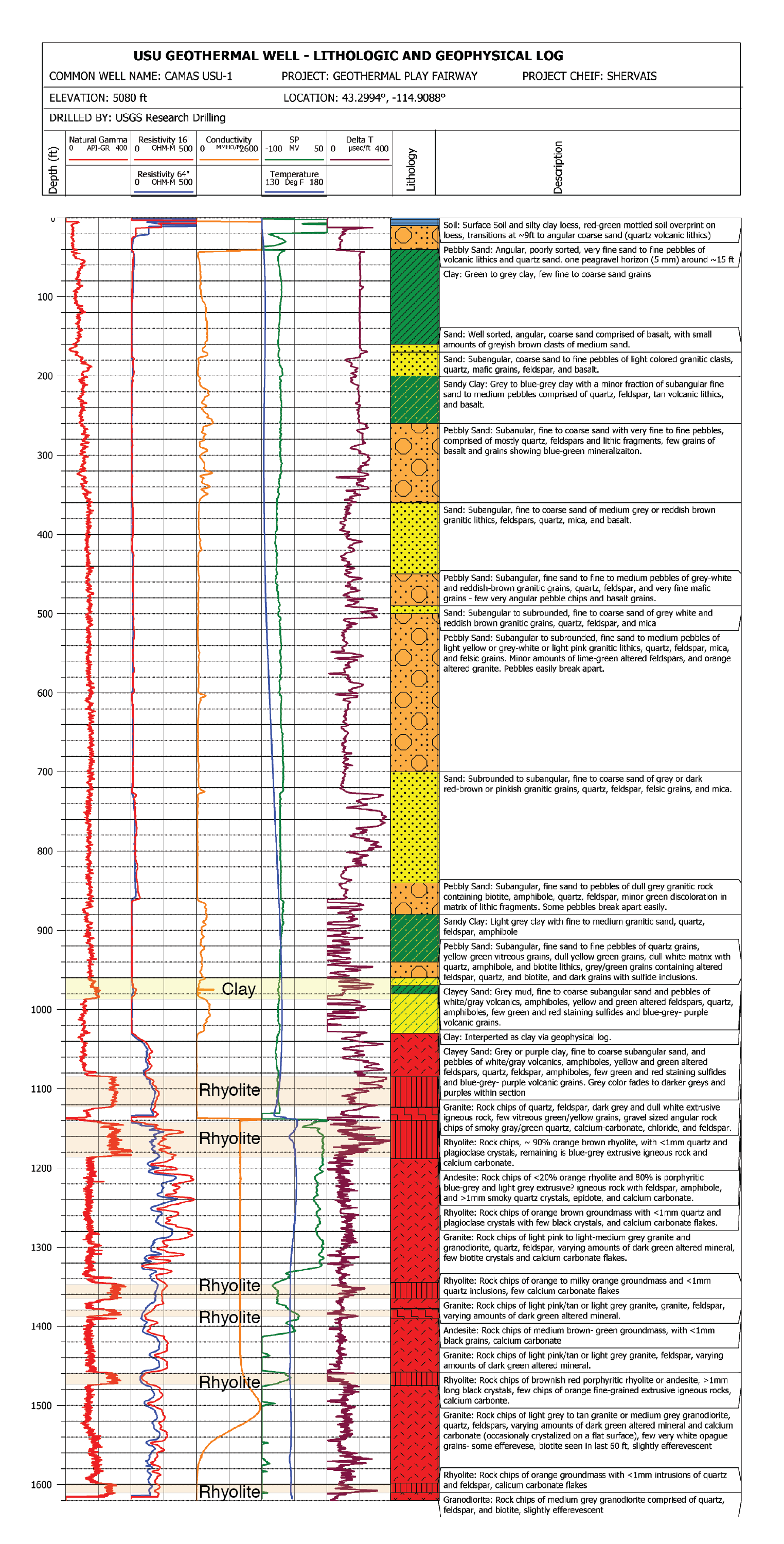
This submission contains documents that describe the USU Camas-1 test well, drilled in Camas Prairie, Idaho, in Fall 2018 and Fall 2019. The purpose of this well is to validate exploration...
Search relevance: 1.00 | Views last month: 0 | Catalog Last Checked: March 23, 2026 at 09:41 PM -
This report details all of the work done in Phase 2 of a geothermal exploration project in Tularosa Basin, New Mexico. Data acquired as part of Phase 2 includes field geology (geological...
Search relevance: 1.00 | Views last month: 0 | Catalog Last Checked: March 23, 2026 at 09:40 PM -
This dataset is part of an effort to highlight the advantages of incorporating low-temperature (< 150 C) geothermal resource evaluation into the implementation of combined heat and power (CHP),...
Search relevance: 1.00 | Views last month: 0 | Catalog Last Checked: April 25, 2026 at 08:43 AM -
These models are related to weights of evidence play fairway anlaysis of the Tularosa Basin, New Mexico and Texas. They were created through Spatial Data Modeler: ArcMAP 9.3 geoprocessing tools...
Search relevance: 1.00 | Views last month: 0 | Catalog Last Checked: March 23, 2026 at 09:39 PM -
This submission contains a link to two USGS data publications. Each data release contains all digital geographic data used and produced by the Snake River Plain Play Fairway Analysis for Phase 1...
Search relevance: 1.00 | Views last month: 0 | Catalog Last Checked: March 23, 2026 at 09:41 PM -
Magnetotelluric (MT) data for Medicine lake with 2km grid.
Search relevance: 1.00 | Views last month: 0 | Catalog Last Checked: March 23, 2026 at 09:39 PM -
SMU Geothermal Lab developed a methodology to estimate shallow (1 km to 4 km) Enhanced Geothermal Systems (EGS) resource potential using an approach that utilizes recent geology and geophysical...
Search relevance: 1.00 | Views last month: 0 | Catalog Last Checked: March 23, 2026 at 09:41 PM -
This submission includes three files from two sources. One file is derived from USGS data and includes a series of manipulations to evaluate only shallow wells with high estimated geothermal...
Search relevance: 1.00 | Views last month: 0 | Catalog Last Checked: March 23, 2026 at 09:39 PM -
This submission contains raster files associated with several datasets that include earthquake density, Na/K geothermometers, fault density, heat flow, and gravity. Integrated together using...
Search relevance: 1.00 | Views last month: 0 | Catalog Last Checked: March 23, 2026 at 09:40 PM -
This submission includes composite risk segment models in raster format for permeability, heat of the earth, and MT, as well as the final PFA model of geothermal exploration risk in Southwestern...
Search relevance: 1.00 | Views last month: 0 | Catalog Last Checked: March 23, 2026 at 09:40 PM -
This is a zipped archive containing an ArcGIS shapefile and a text file containing gravity data covering the Cove Fort and Dog Valley areas in central Utah. Part of the data was acquired by the...
Search relevance: 1.00 | Views last month: 0 | Catalog Last Checked: March 23, 2026 at 09:40 PM -
This submission includes maps of the spatial distribution of basaltic, and felsic rocks in the Oregon Cascades. It also includes a final Play Fairway Analysis (PFA) model, with the heat and...
Search relevance: 1.00 | Views last month: 0 | Catalog Last Checked: March 23, 2026 at 09:39 PM -
Tabular aqueous geochemistry data files for the Play Fairway Analysis CA-NV-OR area.
Search relevance: 1.00 | Views last month: 0 | Catalog Last Checked: March 23, 2026 at 09:39 PM
