Search datasets
-
This dataset contains a variety of data about the Fort Bliss geothermal area, part of the southern portion of the Tularosa Basin, New Mexico. The dataset contains schematic models for the...
Search relevance: 1.00 | Views last month: 6 | Catalog Last Checked: October 15, 2026 at 11:01 PM -
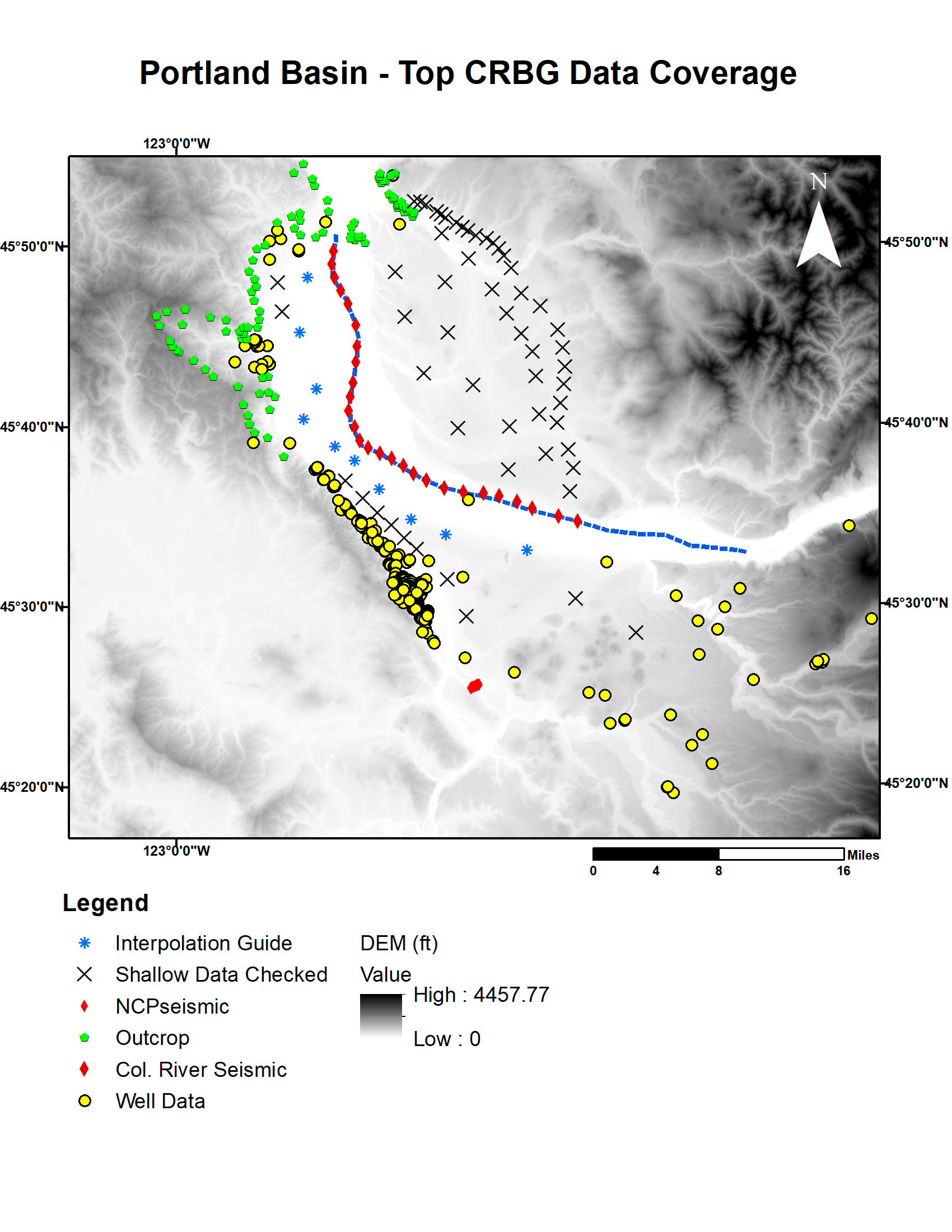
The Portland Basin is a prime location to assess the feasibility of DDU-TES because natural geologic conditions provide thermal and hydraulic separation from overlying aquifers that would...
Search relevance: 1.00 | Views last month: 6 | Catalog Last Checked: October 15, 2026 at 11:02 PM -
Digital surfaces and thicknesses of selected hydrogeologic units of the Floridan aquifer system were developed to define an updated hydrogeologic framework as part of the U.S. Geological Survey...
Search relevance: 1.00 | Views last month: 5 | Catalog Last Checked: September 10, 2026 at 09:42 PM -
This digital dataset was created as part of a U.S. Geological Survey hydrologic resource assessment and development of an integrated numerical hydrologic model of the hydrologic system of the...
Search relevance: 1.00 | Views last month: 5 | Catalog Last Checked: September 10, 2026 at 09:31 PM -
Cross sections are vector features seen on a floodplain map to indicate sections of the stream and floodplain where known discharges and water surface elevations have been calculated. Floodplain...
Search relevance: 1.00 | Views last month: 5 | Catalog Last Checked: October 20, 2026 at 11:18 PM -
Digital surfaces and thicknesses of selected hydrogeologic units of the Floridan aquifer system were developed to define an updated hydrogeologic framework as part of the U.S. Geological Survey...
Search relevance: 1.00 | Views last month: 4 | Catalog Last Checked: October 14, 2026 at 05:30 AM -
This report presents the geologic framework critical in understanding spring discharge and the hydrogeology in Black Canyon directly south of Lake Mead below Hoover Dam, Nevada and Arizona. Most...
Search relevance: 1.00 | Views last month: 3 | Catalog Last Checked: October 15, 2026 at 11:01 PM -
This data release presents a national cross-section (XS) database (NXSDB) of bathymetric cross-sections collected during water year (WY) 2023 (October 1, 2022, to September 30, 2023). The WY 2023...
Search relevance: 1.00 | Views last month: 3 | Catalog Last Checked: September 10, 2026 at 07:55 PM -
This digital dataset defines the traces of geologic and hydrogeologic cross sections that were used in the construction of a digital three-dimensional (3D) hydrogeologic framework model (HFM) of...
Search relevance: 1.00 | Views last month: 3 | Catalog Last Checked: October 14, 2026 at 06:46 AM -
The McGinness Hills geothermal system lies in a ~8.5 km wide, north-northeast trending accommodation zone defined by east-dipping normal faults bounding the Toiyabe Range to the west and...
Search relevance: 1.00 | Views last month: 3 | Catalog Last Checked: October 15, 2026 at 11:01 PM -
This geologic map database compiles, in digital form, geologic data previously published as printed maps showing the altitude of the base of Dakota Sandstone and equivalent rocks on the Colorado...
Search relevance: 1.00 | Views last month: 3 | Catalog Last Checked: September 10, 2026 at 09:42 PM -
The San Emidio geothermal system is characterized by a left-step in a west-dipping normal fault system that bounds the western side of the Lake Range. The 3D geologic model consists of 5 geologic...
Search relevance: 1.00 | Views last month: 2 | Catalog Last Checked: October 15, 2026 at 11:01 PM -
Neal Hot Springs-ESRI Geodatabase (ArcGeology v1.3): - Contains all the geologic map data, including faults, contacts, folds, unit polygons, and attitudes of strata and faults. - List of...
Search relevance: 1.00 | Views last month: 2 | Catalog Last Checked: October 15, 2026 at 11:01 PM -
Geologic cross sections from the West Flank FORGE site. Cross Section traces linked in resources.
Search relevance: 1.00 | Views last month: 2 | Catalog Last Checked: October 15, 2026 at 11:02 PM -
Digital surfaces and thicknesses of selected hydrogeologic units of the Floridan aquifer system were developed to define an updated hydrogeologic framework as part of the U.S. Geological Survey...
Search relevance: 1.00 | Views last month: 2 | Catalog Last Checked: September 10, 2026 at 08:59 PM -
An implementation of the Bote-Salvat ionization cross-section parameterized algorithm for electron image up to 1 GeV. Based on * D. Bote and F. Salvat, "Calculations of inner-shell ionization...
Search relevance: 1.00 | Views last month: 2 | Catalog Last Checked: September 10, 2026 at 05:51 PM -
This data release presents a national cross-section (XS) database (NXSDB) of bathymetric cross-sections collected during water year (WY) 2022 (October 1, 2021, to September 30, 2022). The WY 2022...
Search relevance: 1.00 | Views last month: 2 | Catalog Last Checked: September 10, 2026 at 09:24 PM -
Digital surfaces and thicknesses of selected hydrogeologic units of the Floridan aquifer system were developed to define an updated hydrogeologic framework as part of the U.S. Geological Survey...
Search relevance: 1.00 | Views last month: 2 | Catalog Last Checked: October 20, 2026 at 06:22 AM -
This data set includes Light Detection and Ranging (LiDAR) data, a remote sensing processing report, and a geologic map of the Glass Buttes study area for ORMAT. The total area flown for the...
Search relevance: 1.00 | Views last month: 2 | Catalog Last Checked: October 15, 2026 at 11:02 PM -
This child page contains sediment-size distribution data collected from five sites on the Upper Colorado River, Colorado, during April 6-8, 2022. The five sites selected for monitoring were...
Search relevance: 1.00 | Views last month: 1 | Catalog Last Checked: September 10, 2026 at 09:43 PM