Search datasets
-
Temperature logs, pressure logs, directional survey, well history, well bore schematic, and other reports for well 48-11TCH at West Flank FORGE
Search relevance: 1.00 | Views last month: 8 | Catalog Last Checked: September 10, 2026 at 05:49 PM -
Temperature logs, pressure logs, directional survey, well history, well bore schematic, and other reports for well 74-2TCH at West Flank FORGE
Search relevance: 1.00 | Views last month: 7 | Catalog Last Checked: September 10, 2026 at 05:49 PM -
This submission contains tarred pair directories for interferometric synthetic aperture radar (InSAR) data covering Coso Geothermal Field in California, USA. Explanation of pair...
Search relevance: 1.00 | Views last month: 5 | Catalog Last Checked: September 10, 2026 at 05:50 PM -
A refined earthquake mechanism catalog for southern Califiornia using the HASH method and locations derived from waveform cross-correlation. Each focal mechanism is obtained from grid searching...
Search relevance: 1.00 | Views last month: 3 | Catalog Last Checked: September 10, 2026 at 05:49 PM -
This data includes the locations of the MT data collected in and around the Coso Geothermal field that covered the West Flank area. These are the data that the 3D MT models were created from that...
Search relevance: 1.00 | Views last month: 3 | Catalog Last Checked: September 10, 2026 at 05:49 PM -
The Geothermal Resource Portfolio Optimization and Reporting Technique (GeoRePORT) was developed with funding from the U.S. Department of Energy Geothermal Technologies Office to assist in...
Search relevance: 1.00 | Views last month: 3 | Catalog Last Checked: September 10, 2026 at 05:50 PM -
Fluid inclusion gas analysis for wells in COSO geothermal area, California. Analyses used in developing fluid inclusion stratigraphy for wells and defining fluids across the geothermal fields. ...
Search relevance: 1.00 | Views last month: 3 | Catalog Last Checked: September 10, 2026 at 05:47 PM -
x,y,z data of the 3D temperature model for the West Flank Coso FORGE site. Model grid spacing is 250m. The temperature model for the Coso geothermal field used over 100 geothermal production...
Search relevance: 1.00 | Views last month: 3 | Catalog Last Checked: September 10, 2026 at 05:49 PM -
PDFs of seismic reflection profiles 101,110, 111 local to the West Flank FORGE site. 45 line kilometers of seismic reflection data are processed data collected in 2001 through the use of...
Search relevance: 1.00 | Views last month: 2 | Catalog Last Checked: September 10, 2026 at 05:49 PM -
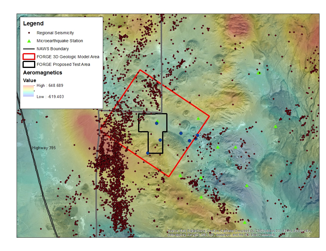
A map with the Coso West Flank FORGE test area outlined, along with regional seismicity, the aeromagnetic data set and the area currently being utilized for the creation of the 3D model.
Search relevance: 1.00 | Views last month: 2 | Catalog Last Checked: September 10, 2026 at 05:49 PM -
Photos and detailed downhole lithology notes for wells CGEH-1 and 74-2 at the West Flank Coso, Ca FORGE location.
Search relevance: 1.00 | Views last month: 2 | Catalog Last Checked: September 10, 2026 at 05:49 PM -
Natural fracture data from wells 33-7, 33A-7,52A-7, 52B-7 and 83-11 at West Flank. Fracture orientations were determined from image logs of these wells (see accompanying submissions). Data files...
Search relevance: 1.00 | Views last month: 2 | Catalog Last Checked: September 10, 2026 at 05:49 PM -
Mineralogical and lithological data from core samples taken at various geothermal wells in the Great Basin: Dixie Valley, Beowawe, Roosevelt, Mammoth, Steamboat Springs, Coso
Search relevance: 1.00 | Views last month: 2 | Catalog Last Checked: September 10, 2026 at 05:48 PM -
Downhole temperature data for the three wells inside the West Flank FORGE footprint; 83-11, TCH 74-2 and TCH 48-11. TCH 74-2 and TCH 48-11 were both collected before 1990 and 83-11 was collected...
Search relevance: 1.00 | Views last month: 2 | Catalog Last Checked: September 10, 2026 at 05:49 PM -
FMI image log and mud log of well 52B-7
Search relevance: 1.00 | Views last month: 2 | Catalog Last Checked: September 10, 2026 at 05:49 PM -
Circumferential Borehole Imaging Log (CBIL) image log as DLIS file, and PDF mud log of well 33A-7 as part of the West Flank Coso, CA FORGE site.
Search relevance: 1.00 | Views last month: 1 | Catalog Last Checked: September 10, 2026 at 05:49 PM -
CBIL and STAR image logs as pre-processed DLIS files, and mud log of well 83-11
Search relevance: 1.00 | Views last month: 1 | Catalog Last Checked: September 10, 2026 at 05:49 PM -
Aeromagnetic data was collected over the Indian Wells Valley, CA in November 1994. It consisted of 9,033 line-kilometers covering ~4,150 square kilometers, flown at a 250 meter drape with...
Search relevance: 1.00 | Views last month: 1 | Catalog Last Checked: September 10, 2026 at 05:48 PM -
Mud logs for wells 83-11, 68-6, 33A-7, 33A-7RD, 52B-7, and 88-1 at West Flank
Search relevance: 1.00 | Views last month: 1 | Catalog Last Checked: September 10, 2026 at 05:49 PM