

2023 National Offshore Wind data set (NOW-23)
Access & Use Information
Downloads & Resources
-
AWS Public Dataset Registry PageHTML
This is the AWS public dataset registry page for the dataset. WRF outputs can...
-
Great Lakes Offshore Wind Resource DataHTML
Includes h5 files containing offshore wind resource data for the Great Lakes....
-
Hawaii Offshore Wind Resource DataHTML
Includes h5 files containing offshore wind resource data for Hawaii. Data is...
-
Original WIND Toolkit DataHTML
The data found in the current submission is an updated and longer version of...
-
Mid Atlantic Offshore Wind Resource DataHTML
Includes h5 files containing offshore wind resource data for the Mid...
-
North Pacific Offshore Wind Resource DataHTML
Includes h5 files containing offshore wind resource data for the North...
-
Deprecated - California Offshore Wind Resource DataHTML
Includes h5 files containing offshore wind resource data for California. Data...
-
North Atlantic Offshore Wind Resource DataHTML
Includes h5 files containing offshore wind resource data for the North...
-
Gulf of Mexico Wind Resource DataHTML
Includes h5 files containing offshore wind resource data for the Gulf of...
-
List of variables included in the NOW-23 HDF5 files.txtTEXT
List of variables in the HDF5 output files for the US Offshore Wind Resource...
-
Data Access and HSDS Usage Exampleshtml#data-access-examples
Examples of using the HSDS Service to Access NOW-23 data. Contains resources...
-
WRF Namelist Files for NOW-23 Data v1.zipZIP
WRF namelist files that describe the model setup used to run all the regional...
-
South Atlantic Offshore Wind Resource DataHTML
Includes h5 files containing offshore wind resource data for the South...
-
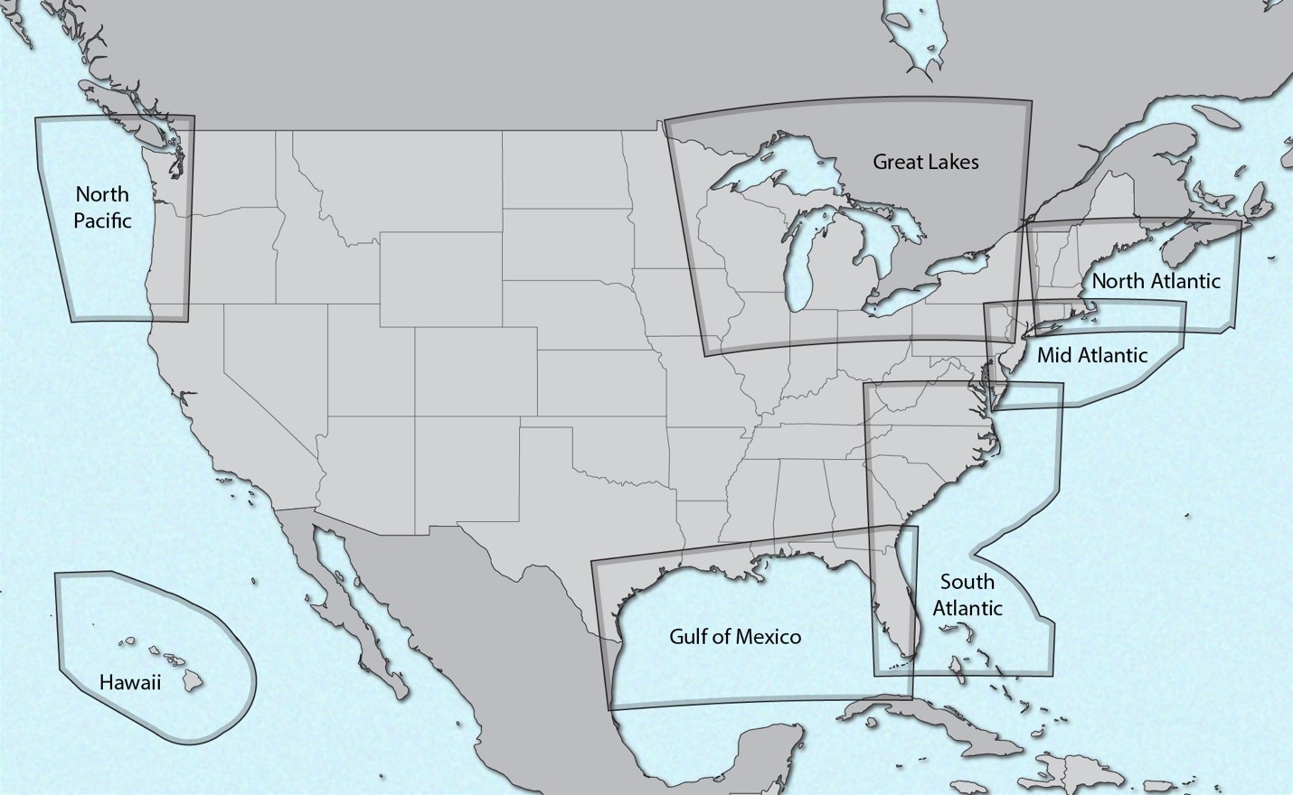
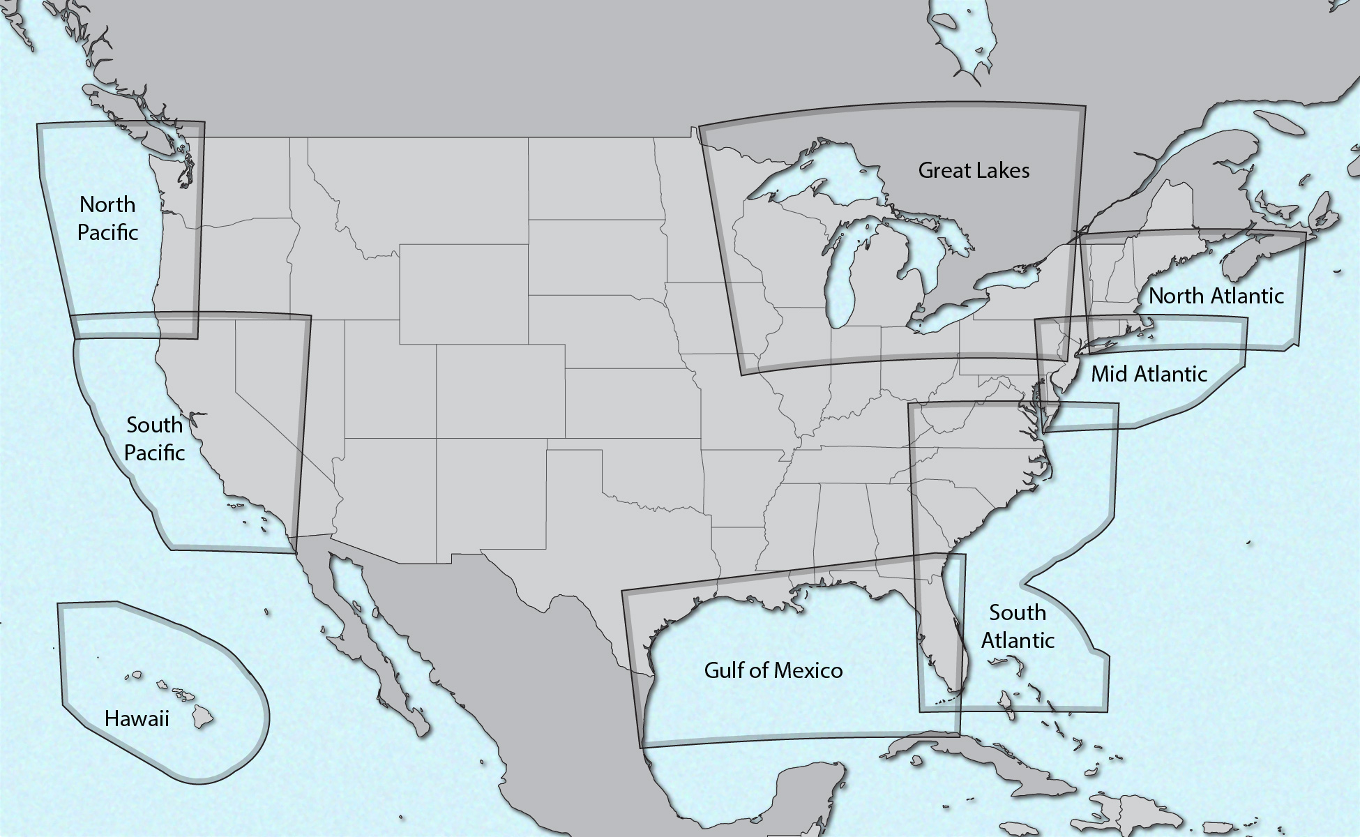
Deprecated_Map_of_Wind_Regions.jpgJPEG
Map of contiguous United States plus Hawaii, outlining the domain of each...
-
WRF Namelist Files for NOW-23 Data v2.zipZIP
WRF namelist files that describe the model setup used to run all the regional...
-
NOW-23_Sample_Data_Files.zipZIP
NOW-23 sample data files, in .csv format, created using the rex extraction...
-
WRG files for NOW-23 data set.zipZIP
Includes WRG files for all NOW-23 domains, calculated at 80, 120, 160, and...
-
California Offshore Wind Resource Data0%2F
Includes h5 files containing offshore wind resource data for California. Data...
-
NOW-WAKES Mid AtlanticHTML
Includes h5 files containing offshore wind resource data with modeled wakes...
-
Map_of_Wind_Regions.pngPNG
Map of contiguous United States plus Hawaii, outlining the domain of each...
-
Landing PageLanding Page
Dates
| Metadata Created Date | September 22, 2021 |
|---|---|
| Metadata Updated Date | March 12, 2024 |
Metadata Source
- Data.json Data.json Metadata
Harvested from OpenEI data.json
Additional Metadata
| Resource Type | Dataset |
|---|---|
| Metadata Created Date | September 22, 2021 |
| Metadata Updated Date | March 12, 2024 |
| Publisher | National Renewable Energy Laboratory |
| Maintainer | |
| Doi | 10.25984/1821404 |
| Identifier | https://data.openei.org/submissions/4500 |
| Data First Published | 2020-01-01T07:00:00Z |
| Data Last Modified | 2024-03-12T18:47:36Z |
| Public Access Level | public |
| Bureau Code | 019:20 |
| Metadata Context | https://openei.org/data.json |
| Metadata Catalog ID | https://openei.org/data.json |
| Schema Version | https://project-open-data.cio.gov/v1.1/schema |
| Catalog Describedby | https://project-open-data.cio.gov/v1.1/schema/catalog.json |
| Data Quality | True |
| Harvest Object Id | 680d78ae-4f5d-4dd6-b986-00e11e484afc |
| Harvest Source Id | 7cbf9085-0290-4e9f-bec1-91653baeddfd |
| Harvest Source Title | OpenEI data.json |
| Homepage URL | https://data.openei.org/submissions/4500 |
| License | https://creativecommons.org/licenses/by/4.0/ |
| Old Spatial | {"type":"Polygon","coordinates":-180,-83,180,-83,180,83,-180,83,-180,-83} |
| Program Code | 019:010 |
| Projectnumber | FY21 AOP 1.4.91.404 |
| Projecttitle | A Validated National Offshore Wind Resource Dataset with uncertainty Quantification (NYSERDA) |
| Source Datajson Identifier | True |
| Source Hash | 1842617b88e75241e4abb08348907ff6191e8de6230ac4e0bca2406adcfd3687 |
| Source Schema Version | 1.1 |
| Spatial | {"type":"Polygon","coordinates":-180,-83,180,-83,180,83,-180,83,-180,-83} |
Didn't find what you're looking for? Suggest a dataset here.