
-
Federal
Sea level measured by tide gauges from global oceans as part of the Joint Archive for Sea Level (JASL) since 1846
National Oceanic and Atmospheric Administration, Department of Commerce —
This collection contains the complete holdings of the Joint Archive for Sea Level (JASL) for hourly and daily data that have been quality controlled, assessed, and... -
Federal
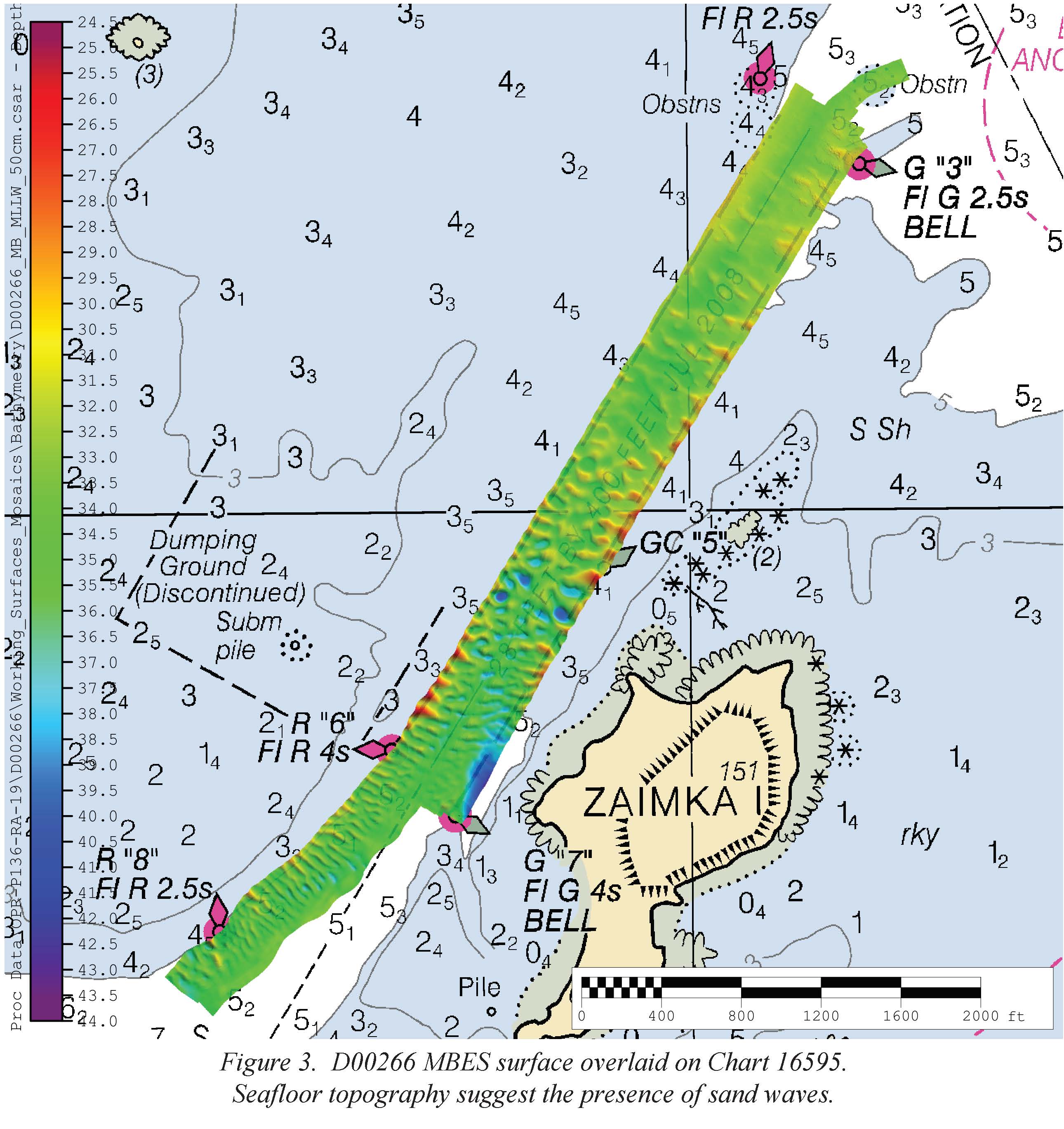
D00266: NOS Hydrographic Survey , 2019-05-20
National Oceanic and Atmospheric Administration, Department of Commerce —
The National Oceanic and Atmospheric Administration (NOAA) has the statutory mandate to collect hydrographic data in support of nautical chart compilation for safe... -
Federal
AFSC/RACE/SAP/Swiney: Primiparous and multiparous Tanner crab egg extrusion, embryo development and hatching
National Oceanic and Atmospheric Administration, Department of Commerce —
This study compares timing of egg extrusion, embryo development, timing and duration of eclosion, and incubation periods of Kodiak, Alaska primiparous and multiparous... -
Federal
AFSC/FMA/NPRB Alternative Catch Monitoring Table and Column Definitions
National Oceanic and Atmospheric Administration, Department of Commerce —
These data arise from a field study of groundfish catch monitoring in Kodiak, AK trawl fisheries. Two monitoring components were included in the study: 1) at-sea... -
Federal
Directional wave measurements, sea surface temperatures, and additional ocean surface parameters recorded by the Scripps Institution of Oceanography's Coastal Data Information Program network of Datawell Waverider buoys since September 1991
National Oceanic and Atmospheric Administration, Department of Commerce —
The foundation of this ongoing collection are high-resolution directional wave spectra and parameters measured by Datawell Waverider buoys deployed across US waters.... -
Federal
Simplified refuge boundaries in the Alaska Region (geoJSONs for import into mdEditor)
Department of the Interior —
These polygon features depict simplified boundaries of the national wildlife refuges and refuge complexes in the Alaska Region for small-scale reference. They were... -
Federal
Kodiak, Alaska 8 arc-second MHW Coastal Digital Elevation Model
National Oceanic and Atmospheric Administration, Department of Commerce —
The 8-second Kodiak, Alaska Elevation Grid provides bathymetric data of 8-second resolution in geographic coordinates. This grid is strictly for tsunami inundation... -
Federal
H11338: NOS Hydrographic Survey , Sitkalidak Shoal Investigation, Alaska, 2004-06-17
National Oceanic and Atmospheric Administration, Department of Commerce —
The National Oceanic and Atmospheric Administration (NOAA) has the statutory mandate to collect hydrographic data in support of nautical chart compilation for safe... -
Federal
H12683: NOS Hydrographic Survey , 2014-08-06
National Oceanic and Atmospheric Administration, Department of Commerce —
The National Oceanic and Atmospheric Administration (NOAA) has the statutory mandate to collect hydrographic data in support of nautical chart compilation for safe... -
Federal
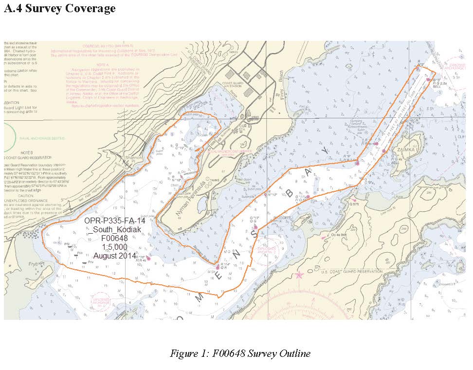
F00648: NOS Hydrographic Survey , 2014-08-18
National Oceanic and Atmospheric Administration, Department of Commerce —
The National Oceanic and Atmospheric Administration (NOAA) has the statutory mandate to collect hydrographic data in support of nautical chart compilation for safe... -
State
Updated tsunami inundation maps of the Kodiak area, Alaska
State of Alaska —
Staff from Alaska Earthquake Center, Geophysical Institute and Alaska Division of Geological & Geophysical Surveys evaluated potential potential tsunami hazard... -
State
Tsunami hazard maps of the Kodiak area, Alaska
State of Alaska —
This report is intended to provide guidance to local emergency managers in tsunami hazard assessment. Tsunami waves are a real threat for many Alaskan coastal... -
Federal
AFSC NPRB Conrath Conners Octopus Studies 2009-2011 Kodiak Alaska Life History and Habitat Pot Gear
National Oceanic and Atmospheric Administration, Department of Commerce —
Data collected during 2010-2011 field studies of giant Pacific octopus Enteroctopus dofleini for NPRB. Includes data on habitat pot gear study: fishing locations, pot... -
Federal
AFSC/FMA/Observer Logistics System (OLS)
National Oceanic and Atmospheric Administration, Department of Commerce —
Alaska groundfish fisheries observers have been monitoring domestic groundfish fishing activities in the U.S. Exclusive Economic Zone (EEZ) off Alaska for over twenty... -
Federal
AFSC/RACE/SAP/Long: Data from: Habitat, predation, growth, and coexistence: Could interactions between juvenile red and blue king crabs limit blue king crab productivity?
National Oceanic and Atmospheric Administration, Department of Commerce —
This data set is from a series of laboratory experiments examining the interactions between red and blue king crabs and habitat. We examined how density and predator... -
Federal
AFSC/RACE/GAP: RACEBASE Database
National Oceanic and Atmospheric Administration, Department of Commerce —
The core function of the Resource Assessment and Conservation Engineering (RACE) Division is to conduct quantitative fishery surveys and related ecological and... -
Federal
AFSC/RACE/SAP/Long: Data from: A novel quantitative model of multiple discrete stage transitions applied to crustacean larval development
National Oceanic and Atmospheric Administration, Department of Commerce —
This data set describes the holding temperatures and developmental stages of larvae of red and blue king crab (Paralithodes camtschaticus and P. platypus) reared to... -
Federal
AFSC/RACE/SAP/Long: Effects of ocean acidification on respiration, feeding, and growth of juvenile red and blue king crabs (Paralithodes camtschaticus and P. platypus)
National Oceanic and Atmospheric Administration, Department of Commerce —
Juvenile red and blue king crabs (Paralithodes camtschaticus and P. platypus) were exposed to three pH levels: ambient (pH 8.1), pH 7.8, and pH 7.5 for three weeks.... -
Federal
Kodiak, Alaska 1/3 arc-second MHW Coastal Digital Elevation Model
National Oceanic and Atmospheric Administration, Department of Commerce —
NOAA's National Geophysical Data Center (NGDC) is building high-resolution digital elevation models (DEMs) for select U.S. coastal regions. These integrated...

Official websites use .gov
A
.gov website belongs to an official government
organization in the United States.
Secure .gov websites use HTTPS
A
lock (
) or https:// means you’ve safely connected to
the .gov website. Share sensitive information only on official,
secure websites.
.jpg)