
-
Federal
BOREAS Regional DEM in Raster Format and AEAC Projection
National Aeronautics and Space Administration —
Based on the GTOPO30 DEM produced by the USGS EDC. The BOREAS region was extracted from the GTOPO30 data and reprojected by BOREAS staff into the AEAC projection. -
Federal
BOREAS DEM Data over the NSA-MSA and SSA-MSA in AEAC Projection
National Aeronautics and Space Administration —
AEAC projection of the original DEMs produced by the BOREAS HYD-08 team. -
Federal
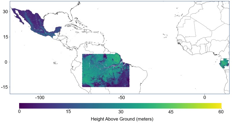
Pantropical Forest Height and Biomass from GEDI and TanDEM-X Data Fusion
National Aeronautics and Space Administration —
This dataset includes maps of canopy height and aboveground biomass at spatial resolutions of 25 m and 100 m for Mexico, Gabon, French Guiana, and the Amazon Basin.... -
Federal
LiDAR Data, DEM, and Maximum Vegetation Height Product from Southern Idaho, 2014
National Aeronautics and Space Administration —
This dataset provides the point cloud data derived from small footprint waveform LiDAR data collected in August 2014 over Reynolds Creek Experimental Watershed and... -
Federal
LBA-ECO LC-03 Hypsography, Rivers, Roads, and DEM, Four Areas across Brazilian Amazon
National Aeronautics and Space Administration —
This data set provides four related spatial data products for four study areas across the Brazilian Amazon: Manaus, Amazonas; Tapajos National Forest, Para Western... -
Federal
BOREAS HYD-08 DEM Data over the NSA-MSA and SSA-MSA in UTM Projection
National Aeronautics and Space Administration —
DEMs produced from digitized contours at a cell resolution of 100 meters. -
Federal
Delta-X: Digital Elevation Model, MRD, LA, USA, 2021
National Aeronautics and Space Administration —
This dataset provides an updated digital elevation model (DEM) for the Atchafalaya and Terrebonne basins in coastal Louisiana, USA. The DEM is updated from the Pre-... -
Federal
Digital Elevation Models for the Global Change Research Wetland, Maryland, USA, 2016
National Aeronautics and Space Administration —
This dataset contains four alternative digital elevation models (DEMs) at 1 m resolution and model performance statistical metrics for the Global Change Research... -
Federal
Pre-Delta-X: Channel Bathymetry of the Atchafalaya Basin, LA, USA, 2016
National Aeronautics and Space Administration —
This dataset provides water depths and water surface elevations collected during bathymetric surveys of the main channel of the Wax Lake Delta within the Mississippi... -
Federal
LBA Regional Climate Data, 0.5-Degree Grid, 1960-1990 (Willmott and Webber)
National Aeronautics and Space Administration —
This data set is a subset of a 0.5-degree gridded temperature and precipitation data set for South America (Willmott and Webber 1998). This subset was created for the... -
Federal
LBA-ECO CD-06 Physical, Political, and Hydrologic Maps, Ji-Parana River Basin, Brazil
National Aeronautics and Space Administration —
This data set contains physical, hydrologic, political, demographic, and societal maps for the Ji-Parana River Basin, in the state of Rondonia, Brazil. These data... -
Federal
LBA-ECO LC-15 SRTM30 Digital Elevation Model Data, Amazon Basin: 2000
National Aeronautics and Space Administration —
This dataset provides a subset of the SRTM30 Digital Elevation Model (DEM) elevation and standard deviation data for the Amazon Basin. SRTM30 is a near-global digital... -
Federal
LBA-ECO LC-02 Tributary Coordinates, Acre River, Tri-national River Basin: 2003-2004
National Aeronautics and Space Administration —
This data set provides coordinates for points at the mouth of tributaries of the Acre River in the Tri-national River Basin in South America. Three Global Positioning... -
Federal
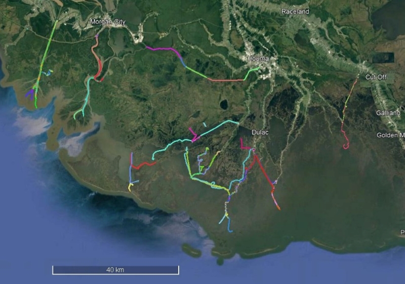
Delta-X: Sonar Bathymetry Survey of Channels, MRD, Louisiana, 2021
National Aeronautics and Space Administration —
This dataset includes bathymetry data for water channels in a portion of the Mississippi River Delta (MRD) of coastal Louisiana. The data were collected using sonar... -
Federal
AfriSAR: Aboveground Biomass for Lope, Mabounie, Mondah, and Rabi Sites, Gabon
National Aeronautics and Space Administration —
This dataset provides gridded estimates of aboveground biomass (AGB) for four sites in Gabon at 0.25 ha (50 m) resolution derived with field measurements and airborne... -
Federal
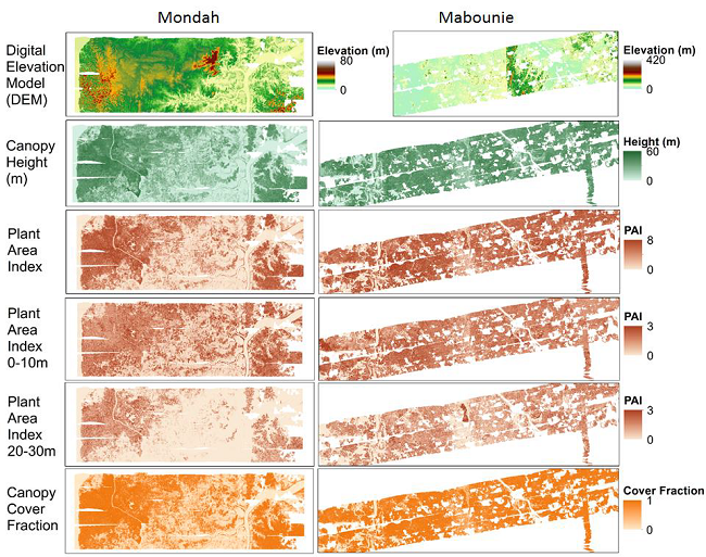
AfriSAR: Gridded Forest Biomass and Canopy Metrics Derived from LVIS, Gabon, 2016
National Aeronautics and Space Administration —
This dataset contains gridded forest characterization products derived from full-waveform lidar data acquired by NASA's airborne Land, Vegetation, and Ice Sensor... -
Federal
Aboveground Biomass Density for High Latitude Forests from ICESat-2, 2020
National Aeronautics and Space Administration —
This dataset provides estimates of Aboveground dry woody Biomass Density (AGBD) for high northern latitude forests at a 30-m spatial resolution. It is designed both... -
Federal
SAFARI 2000 Digital Elevation Model, 1-km (GLOBE)
National Aeronautics and Space Administration —
This data set consists of a southern African subset of the Global Land One-Kilometer Base Elevation (GLOBE) digital elevation model (DEM) data in both ASCII GRID and... -
Federal
CMS: Mangrove Canopy Height Estimates from Remote Imagery, Zambezi Delta, Mozambique
National Aeronautics and Space Administration —
This data set provides high resolution canopy height estimates for mangrove forests in the Zambezi Delta, Mozambique, Africa. The estimates were derived from three... -
Federal
Maps of Vegetation Types and Physiographic Features, Imnavait Creek, Alaska
National Aeronautics and Space Administration —
This dataset provides the spatial distribution of vegetation types, soil carbon, and physiographic features in the Imnavait Creek area, Alaska. Specific attributes...

Official websites use .gov
A
.gov website belongs to an official government
organization in the United States.
Secure .gov websites use HTTPS
A
lock (
) or https:// means you’ve safely connected to
the .gov website. Share sensitive information only on official,
secure websites.