AfriSAR: Gridded Forest Biomass and Canopy Metrics Derived from LVIS, Gabon, 2016
Access & Use Information
Downloads & Resources
-
Google Scholar search resultsHTML
Search results for publications that cite this dataset by its DOI.
-
Download this datasetHTML
This link allows direct data access via Earthdata login
-
View documentation related to this datasetHTML
ORNL DAAC Data Set Documentation
-
This dataset's landing pageHTML
Data set Landing Page DOI URL
-
View documentation related to this datasetPDF
AfriSAR: Gridded Forest Biomass and Canopy Metrics Derived from LVIS, Gabon,...
-
Get a related visualizationPNG
Gridded Land, Vegetation, and Ice Sensor (LVIS) instrument data products at...
-
Landing PageLanding Page
Dates
| Metadata Created Date | July 27, 2023 |
|---|---|
| Metadata Updated Date | December 7, 2023 |
Metadata Source
- Data.json Data.json Metadata
Harvested from NASA Data.json
Graphic Preview

Additional Metadata
| Resource Type | Dataset |
|---|---|
| Metadata Created Date | July 27, 2023 |
| Metadata Updated Date | December 7, 2023 |
| Publisher | ORNL_DAAC |
| Maintainer | |
| Identifier | C2734261748-ORNL_CLOUD |
| Data First Published | 2020-09-22 |
| Language | en-US |
| Data Last Modified | 2023-07-17 |
| Category | AfriSAR, geospatial |
| Public Access Level | public |
| Bureau Code | 026:00 |
| Metadata Context | https://project-open-data.cio.gov/v1.1/schema/catalog.jsonld |
| Metadata Catalog ID | https://data.nasa.gov/data.json |
| Schema Version | https://project-open-data.cio.gov/v1.1/schema |
| Catalog Describedby | https://project-open-data.cio.gov/v1.1/schema/catalog.json |
| Citation | Armston, J., H. Tang, S. Hancock, S. Marselis, L. Duncanson, J. Kellner, M. Hofton, J.B. Blair, T. Fatoyinbo, and R.O. Dubayah. 2020. AfriSAR: Gridded Forest Biomass and Canopy Metrics Derived from LVIS, Gabon, 2016. ORNL DAAC, Oak Ridge, Tennessee, USA. https://doi.org/10.3334/ORNLDAAC/1775 |
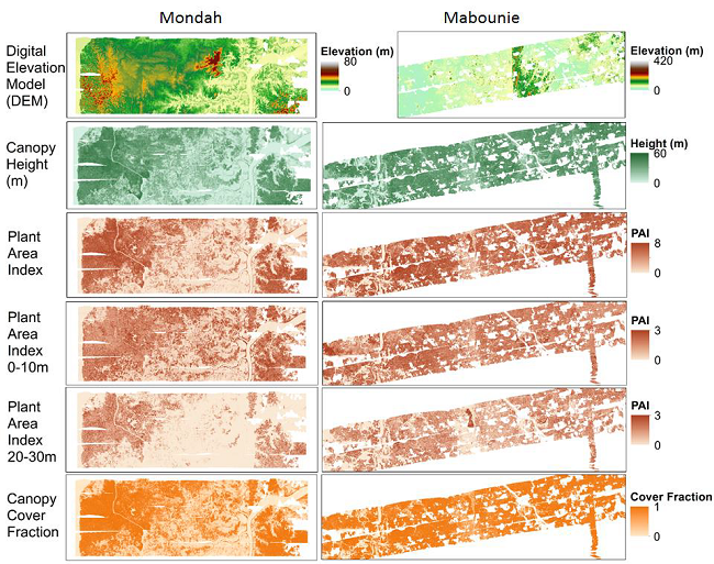
| Graphic Preview Description | Gridded Land, Vegetation, and Ice Sensor (LVIS) instrument data products at 25 m spatial resolution over the Mondah Forest (left) and Mabounie (right) sites in Gabon. Note that the images labeled "DEM" are plotted from the bare ground elevation data files included in the dataset. Source: J. Armston |
| Graphic Preview File | https://daac.ornl.gov/AFRISAR/guides/Afrisar_LVIS_Biomass_VProfiles_Fig1.png |
| Harvest Object Id | 16b9eb0c-d377-4299-bcc9-35c9669f5f26 |
| Harvest Source Id | 58f92550-7a01-4f00-b1b2-8dc953bd598f |
| Harvest Source Title | NASA Data.json |
| Homepage URL | https://doi.org/10.3334/ORNLDAAC/1775 |
| Metadata Type | geospatial |
| Old Spatial | 9.18 -2.29 12.02 0.63 |
| Program Code | 026:001 |
| Source Datajson Identifier | True |
| Source Hash | 75b463cf9cad038bc94d959901fdf95bc436d0a8203e21a85204a597e8c15c10 |
| Source Schema Version | 1.1 |
| Spatial | |
| Temporal | 2016-02-20T00:00:00Z/2016-03-08T23:59:59Z |
Didn't find what you're looking for? Suggest a dataset here.

