

53 datasets found
-
Federal
A Time Series of Herbaceous Annual Cover in the Sagebrush Ecosystem
Department of the Interior —
We integrated 250-m enhanced Moderate Resolution Imaging Spectroradiometer (eMODIS) Normalized Difference Vegetation Index (NDVI) with land cover, biogeophysical... -
Federal
Snake River Plain FORGE: Well Data for INEL-1
Department of Energy —
Well data for the INEL-1 well located in eastern Snake River Plain, Idaho. This data collection includes caliper logs, lithology reports, borehole logs, temperature... -
Federal
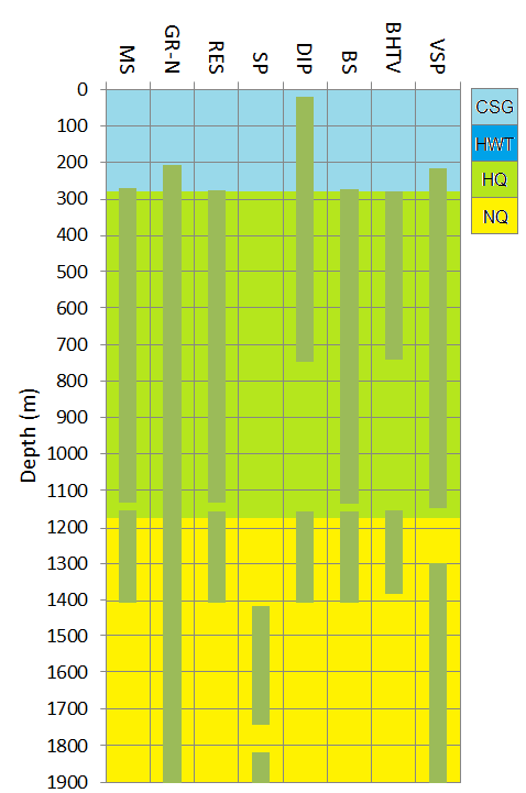
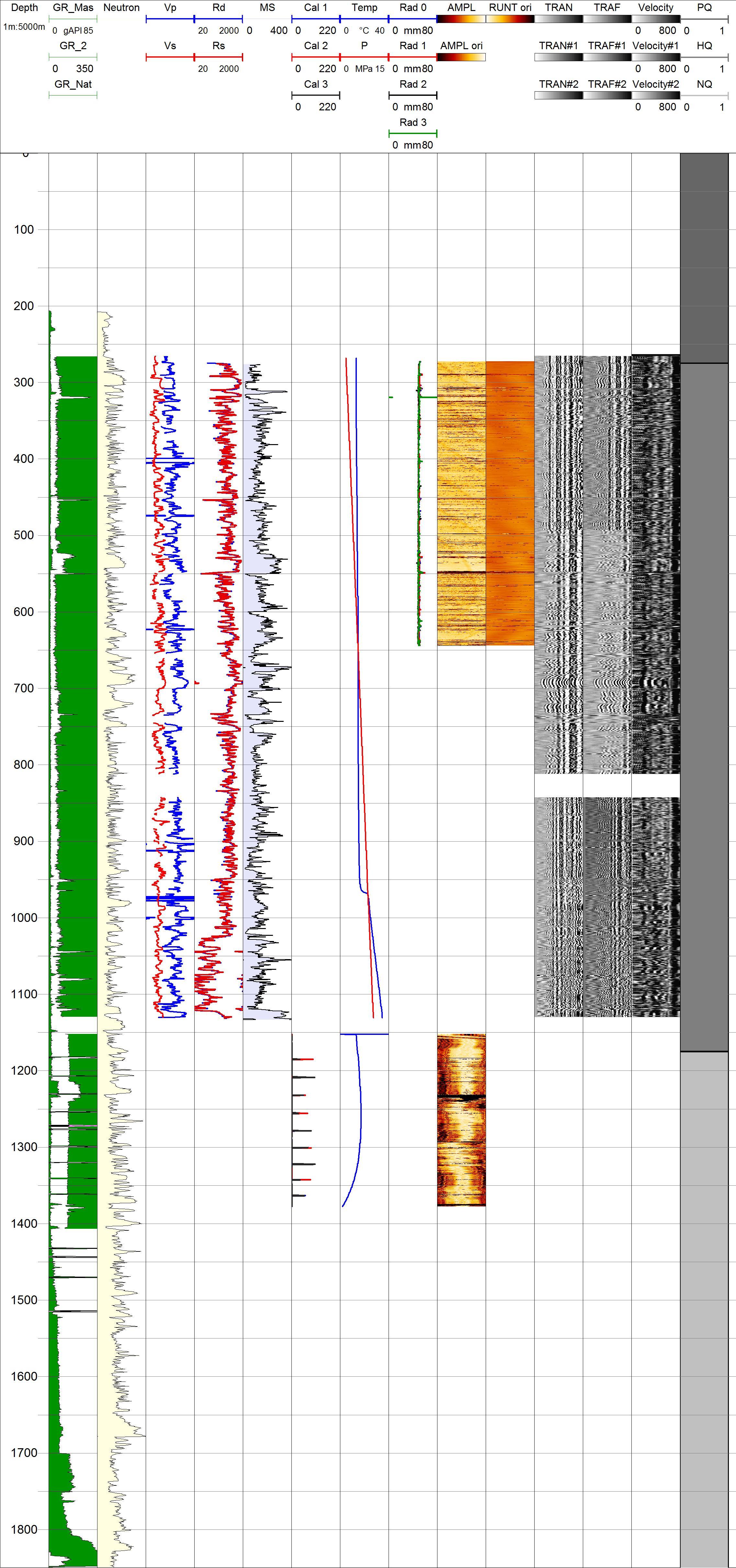
Project HOTSPOT: Kimberly Well Borehole Geophysics Database
Department of Energy —
The Snake River Plain (SRP), Idaho, hosts potential geothermal resources due to elevated groundwater temperatures associated with the thermal anomaly Yellowstone-... -
Federal
Snake River Plain FORGE: Well Data for USGS-142
Department of Energy —
Well data for the USGS-142 well located in eastern Snake River Plain, Idaho. This data collection includes lithology reports, borehole logs, and photos of rhyolite... -
Federal
First Results Project Hotspot Drilling
Department of Energy —
Project Hotspot drilled 3 slim hole exploratory wells in southern Idaho, each just under 2 km deep. These holes were designed to investigate thermal structure in... -
Federal
Hydrogeologic Framework of the Treasure Valley and Surrounding Area, Idaho and Oregon; Hydrogeologic Framework Model
Department of the Interior —
A three-dimensional hydrogeologic framework model (3D HFM) of the westernmost western Snake River Plain (WSRP) aquifer system was prepared to represent the subsurface... -
Federal
2019 Near-real-time Herbaceous Annual Cover in the Sagebrush Ecosystem, USA, July 2019
Department of the Interior —
This dataset provides a near-real-time estimate of 2019 herbaceous annual cover with an emphasis on annual grass (Boyte and Wylie. 2016. Near-real-time cheatgrass... -
Federal
Snake River Plain Geothermal Play Fairway Analysis Heat, Permeability, and Seal CRS Map Raster Files
Department of Energy —
Snake River Plain Play Fairway Analysis - Phase 1 CRS Raster Files. This dataset contains raster files created in ArcGIS. These raster images depict Common Risk... -
Federal
Snake River Plain Play Fairway Analysis: Phase 1 Report
Department of Energy —
This presents the results of Phase 1 of the Snake River Plain Play Fairway Analysis project, along with a proposed work for Phase 2. No new data were collected, but... -
Federal
Projections of Rangeland Fractional Component Cover Across Western Northern American Rangelands for Representative Concentration Pathways (RCP) 4.5 and 8.5 Scenarios for the 2020s, 2050s, and 2080s Time-Periods
Department of the Interior —
Climate change over the past century has altered vegetation community composition and species distributions across rangelands in the western United States. The scale... -
Federal
Snake River Plain Geothermal Play Fairway Analysis - Volcanic Vents, Lacustrine Sediments, and post-Miocene Faults KMZ files
Department of Energy —
This dataset contain raw data files in kmz files (Google Earth georeference format). These files include volcanic vent locations and age, the distribution of fine-... -
Federal
BLM Idaho Craters of the Moon Natl Monument and Preserve Admin Boundaries
Department of the Interior —
This coverage displays the official exterior boundaries of the Craters of the Moon National Monument as surveyed by the BLM in 2001 or obtained from previously... -
Federal
Project HOTSPOT: Kimama Well Borehole Geophysics Database
Department of Energy —
The Snake River Plain (SRP), Idaho, hosts potential geothermal resources due to elevated groundwater temperatures associated with the thermal anomaly Yellowstone-...
53 datasets found