

Project HOTSPOT: Kimberly Well Borehole Geophysics Database
Access & Use Information
Downloads & Resources
-
Borehole Geophysics Data.laslas
Composite WellCAD file of borehole geophysics (raw data) from Kimberly well,...
-
Image Log Raw Data.txtTEXT
Data associated with composite log image of borehole geophysics from Kimberly...
-
Logging Summary.pngPNG
Summary figure of borehole geophysics from Kimberly well, Snake River Plain,...
-
Image Log.jpgJPEG
Composite log image of borehole geophysics from Kimberly well, Snake River...
-
Resistivity Measurements.csvCSV
CSV file exported from WellCad of primary and secondary resistivity...
-
BH Televiewer - SRSDP045 FAC Oriented.lislis
LIS file of borehole televiewer
-
BH Televiewer - SRSDP051 FAC Oriented.lislis
LIS file of borehole televiewer
-
BH Televiewer - SRSDP030 FAC Oriented.lislis
LIS file of borehole televiewer
-
Magnetic Susceptibility.csvCSV
CSV file exported from WellCad of magnetic susceptibility measurements.
-
Thorium Readings.csvCSV
CSV file exported from WellCAD of thorium readings
-
Potassium Readings.csvCSV
CSV file exported from WellCAD of potassium readings
-
Uranium Readings.csvCSV
CSV file exported from WellCAD of uranium readings
-
Potassium Thorium and Uranium Readings.csvCSV
CSV file exported from WellCAD of potassium, thorium, and uranium readings
-
Seismic Profile Data - SRSDP030 BS Shifted NEAR.sgysgy
SGY file of vertical seismic profile data (1114-1787) NEAR
-
Seismic Profile Data - SRSDP055 Shifted NEAR.sgysgy
SGY file of vertical seismic profile data (197-285) NEAR
-
Seismic Profile Data - SRSDP047 NEAR.sgysgy
SGY file of vertical seismic profile data (625-1030) NEAR
-
Seismic Profile Data - SRSDP046 Shifted NEAR.sgysgy
SGY file of vertical seismic profile data (966-1129) NEAR
-
Seismic Profile Data - SRSDP029 Shifted NEAR.sgysgy
SGY file of vertical seismic profile data (1799-1893) NEAR
-
Seismic Profile Data - SRSDP030 BS Shifted FAR.sgysgy
SGY file of vertical seismic profile data (1114-1787) FAR
-
Seismic Profile Data - SRSDP055 Shifted FAR.sgysgy
SGY file of vertical seismic profile data (197-285) FAR
-
Seismic Profile Data - SRSDP046 Shifted FAR.sgysgy
SGY file of vertical seismic profile data (966-1129) FAR
-
Seismic Profile Data - SRSDP029 Shifted FAR.sgysgy
SGY file of vertical seismic profile data (1799-1893) FAR
-
Seismic Profile Data - SRSDP047 FAR.sgysgy
SGY file of vertical seismic profile data (625-1030) FAR
-
Sonic Full Waveforms - SRSDP029 BS.lislis
LIS file of sonic full waveforms
-
Sonic Full Waveforms - SRSDP046 BS.lislis
LIS file of sonic full waveforms
-
Sonic Full Waveforms - SRSDP030 BS.lislis
LIS file of sonic full waveforms
-
Sonic Full Waveforms - SRSDP047 BS.lislis
LIS file of sonic full waveforms
-
Sonic Full Waveforms - SRSDP055 BS.lislis
LIS file of sonic full waveforms
-
Sonic Data.csvCSV
CSV file exported from WellCAD of primary and secondary velocity
-
Stratigraphy.pdfPDF
PDF file of lithology in the Kimberly and local wells.
-
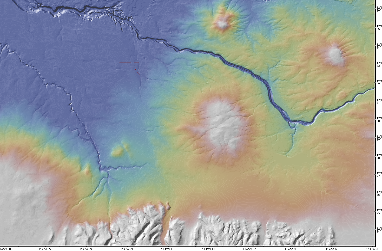
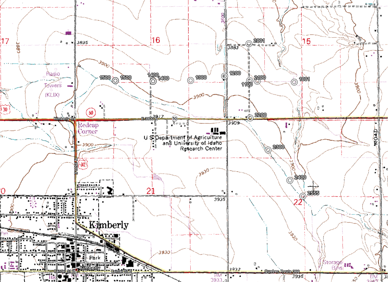
Seismic Line Locations.pngPNG
Color-shaded map of topography with seismic lines in red.
-
Seismic Station Locations.pngPNG
Contour topohraphy map with seismic stations as ○
-
Neutron Measurements.csvCSV
CSV file exported from WellCad of neutron measurements
-
Neutron Measurements.laslas
LAS file of neutron measurements
-
Dipmeter Data - SRSDP054 Shifted.txtTEXT
Text file of dipmeter data
-
Dipmeter Data - SRSDP003 Shifted.txtTEXT
Text file of dipmeter data
-
Dipmeter Data - SRSDP039 Shifted.txtTEXT
Text file of dipmeter data
-
Dipmeter Data - SRSDP053 Shifted.txtTEXT
Text file of dipmeter data
-
Dipmeter Measurements - Kimberly_Rad.csvCSV
CSV file exported from WellCad of dipmeter measurements.
-
Dipmeter Data - SRSDP041 Shifted.txtTEXT
Text file of dipmeter data
-
Dipmeter Measurements - Kimberly_Cal.csvCSV
CSV file exported from WellCad of dipmeter measurements.
-
Dipmeter Data - SRSDP005 Shifted.txtTEXT
Text file of dipmeter data
-
Dipmeter Data - SRSDP006 Shifted.txtTEXT
Text file of dipmeter data
-
OSG Processing Report.pdfPDF
OSG processing report for downhole logging in June 2011. Report covers types...
-
Pressure Data.csvCSV
CSV file exported from WellCAD of pressure
-
MS Temperature-Depth Data.csvCSV
CSV file exported from WellCAD of temperature with depth
-
Temperature-Depth Data.csvCSV
CSV file exported from WellCAD of temperature with depth
-
Gamma Ray Data.xlsxEXCEL
Excel exported from WellCad of Gamma Ray measurements
-
Landing PageLanding Page
Dates
| Metadata Created Date | June 24, 2021 |
|---|---|
| Metadata Updated Date | June 25, 2021 |
Metadata Source
- Data.json Data.json Metadata
Harvested from OpenEI data.json
Additional Metadata
| Resource Type | Dataset |
|---|---|
| Metadata Created Date | June 24, 2021 |
| Metadata Updated Date | June 25, 2021 |
| Publisher | Utah State University |
| Maintainer | |
| Doi | 10.15121/1148780 |
| Identifier | https://data.openei.org/submissions/3126 |
| Data First Published | 2011-07-04T06:00:00Z |
| Data Last Modified | 2020-01-08T23:27:20Z |
| Public Access Level | public |
| Bureau Code | 019:20 |
| Metadata Context | https://openei.org/data.json |
| Metadata Catalog ID | https://openei.org/data.json |
| Schema Version | https://project-open-data.cio.gov/v1.1/schema |
| Catalog Describedby | https://project-open-data.cio.gov/v1.1/schema/catalog.json |
| Data Quality | True |
| Harvest Object Id | fa14a7e5-ab04-4b9d-a6a2-2c27b9576494 |
| Harvest Source Id | 7cbf9085-0290-4e9f-bec1-91653baeddfd |
| Harvest Source Title | OpenEI data.json |
| Homepage URL | https://gdr.openei.org/submissions/283 |
| License | https://creativecommons.org/licenses/by/4.0/ |
| Old Spatial | {"type":"Polygon","coordinates":114.34257222222,42.549830555556,114.34257222222,42.549830555556,114.34257222222,42.549830555556,114.34257222222,42.549830555556,114.34257222222,42.549830555556} |
| Program Code | 019:006 |
| Projectlead | Mark Ziegenbein |
| Projectnumber | EE0002848 |
| Projecttitle | Recovery Act: The Snake River Geothermal Drilling Project: Innovative Approaches to Geothermal Exploration |
| Source Datajson Identifier | True |
| Source Hash | e88f46156b9db03c14e083ffec3c3cafd0d2e837 |
| Source Schema Version | 1.1 |
| Spatial | {"type":"Polygon","coordinates":114.34257222222,42.549830555556,114.34257222222,42.549830555556,114.34257222222,42.549830555556,114.34257222222,42.549830555556,114.34257222222,42.549830555556} |
Didn't find what you're looking for? Suggest a dataset here.