
-
Federal
EPA Facility Registry Service (FRS): Facility Interests Dataset Download 35 recent views
U.S. Environmental Protection Agency —
This downloadable data package consists of location and facility identification information from EPA's Facility Registry Service (FRS) for all sites that are... -
City
HealthInsuranceCoverage 18 recent views
City of Ferndale, Michigan —
Health insurance coverage rates, from the American Community Survey, 2014 5-year Average, by Zip. For the Detroit Tri-County region. Data Driven Detroit calculated... -
Federal
EPA-Enhanced Qualified Opportunity Zones (January 2021) 16 recent views
U.S. Environmental Protection Agency —
This layer contains Census Tracts that have been designated as Qualified Opportunity Zones and contains additional data determined by the EPA to be of interest to... -
Federal
Toxic Releases/IGD: EF_TRI 11 recent views
U.S. Environmental Protection Agency —
EF_TRI is a subset of facilities from FRS_PROGRAM_FACILITY and associated best-available geospatial coordinates. Facility Registry Service (FRS) data are refreshed... -
Federal
Migration Routes of Mule Deer in the Doyle Herd in California
Department of the Interior —
The Doyle mule deer (Odocoileus hemionus) herd migrates from a winter range in Honey Lake Valley and Upper Long Valley near Doyle, California along US Highway 395 in... -
Federal
Plots of Wind Patterns for the World’s Volcanoes
Department of the Interior —
This product includes rose diagrams and tables of wind patterns at volcanoes listed in the Smithsonian Institution’s Volcanoes of the World Database. At each volcano,... -
Federal
In Support of the U.S. Fish and Wildlife Service 3-Bat Species Status Assessment: Summer Mobile Acoustic Transect Analysis
Department of the Interior —
Through the North American Bat Monitoring Program, Bat Conservation International and U.S. Geological Survey (USGS) collaborated with the U.S. Fish and Wildlife... -
Federal
TRI National Analysis: Mapping Data for the Toxics Release Inventory Releases at Various Geographic Levels
U.S. Environmental Protection Agency —
These data provide mapping, display, and analysis capabilities for the TRI National Analysis data at the following geographic levels: state, county, large aquatic... -
Federal
Global Man-made Impervious Surface (GMIS) Dataset From Landsat
National Aeronautics and Space Administration —
The Global Man-made Impervious Surface (GMIS) Dataset From Landsat consists of global estimates of fractional impervious cover derived from the Global Land Survey... -
Federal
EPA Facility Registry Service (FRS): TRI
U.S. Environmental Protection Agency —
This web feature service contains location and facility identification information from EPA's Facility Registry Service (FRS) for the subset of facilities that link... -
University
Legislative Districts of Idaho for 1992 - 2002 [Historical]
University of Idaho —
The downloadable ZIP file contains Esri shapefiles and PDF maps. Contains the information used to determine the location of the new legislative and congressional... -
Federal
Response of juvenile mussels and amphipods to metal concentrations in water and sediment of streams draining the Tri-State Mining District, Missouri, Kansas and Oklahoma, USA- H. azteca and L. siliquoidea in long term exposures
Department of the Interior —
This data release includes data from laboratory bioassay sediment exposures to Lampsilis siliquoidea and Hyallela azteca. Sediment was collected from streams and... -
Federal
Liquid Robotics Wave Glider, Honey Badger (G3), 2015, MOSE, version 2
National Oceanic and Atmospheric Administration, Department of Commerce —
Liquid Robotics Wave Glider, Honey Badger (G3), 2015, MOSE (version 2, from Cara Wilson). The MAGI mission is to use the Wave Glider to sample the late summer... -
Federal
Water column (CTD) profiles taken off the Oregon coast during the 2007 International Pacific Halibut Commission (IPHC) setline survey (NCEI Accession 0042046)
National Oceanic and Atmospheric Administration, Department of Commerce —
The U.S. West Coast has experienced a hypoxic event every year since 2002. This low dissolved oxygen condition clearly impacts the organisms living there, but it is... -
Federal
NOS CO-OPS Water Level Data, Preliminary, 1-Minute
National Oceanic and Atmospheric Administration, Department of Commerce —
This dataset has recent, preliminary (not quality-controlled), 1-minute, water level (tide) data from NOAA NOS Center for Operational Oceanographic Products and... -
Federal
Liquid Robotics Wave Glider, Honey Badger (G3), 2015, C3
National Oceanic and Atmospheric Administration, Department of Commerce —
Liquid Robotics Wave Glider, Honey Badger (G3), 2015, C3. C3 board number 8215 (not coated) appears as board_id=32, task_id=23. C3 board number 771 (coated) appears... -
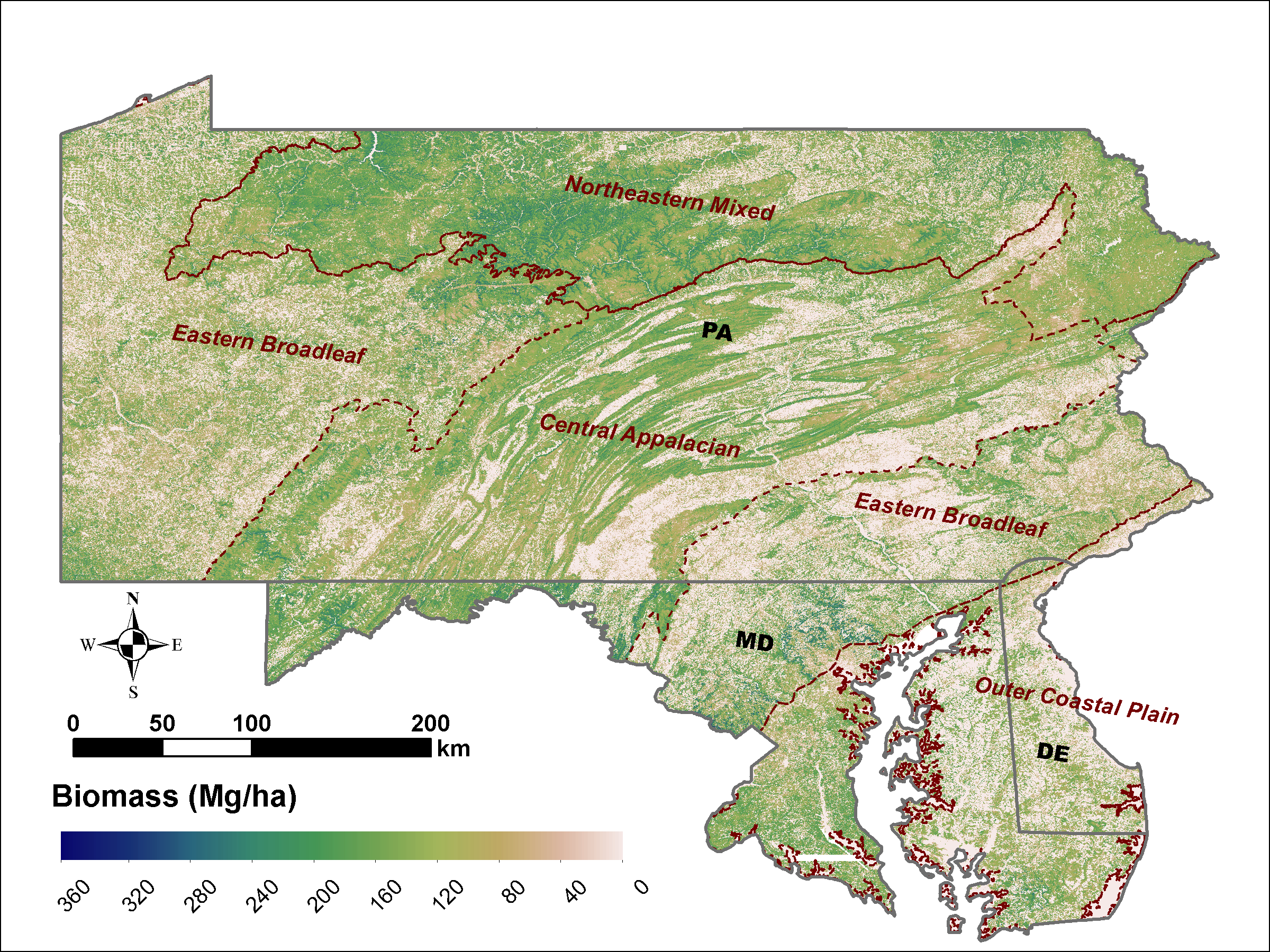
Federal
LiDAR Derived Biomass, Canopy Height and Cover for Tri-State (MD, PA, DE) Region, V2
National Aeronautics and Space Administration —
This dataset provides 30-meter gridded estimates of aboveground biomass (AGB), forest canopy height, and canopy coverage for Maryland, Pennsylvania, and Delaware in... -
Federal
Coral bleaching data from Bleachwatch in the Florida Keys National Marine Sanctuary from 2022-06-01 to 2022-10-26 (NCEI Accession 0276272)
National Oceanic and Atmospheric Administration, Department of Commerce —
As the occurence and severity of coral bleaching has increased in the Florida Keys National Marine Sanctuary (FKNMS) since the 1980âs, The U.S. National Oceanic and... -
Federal
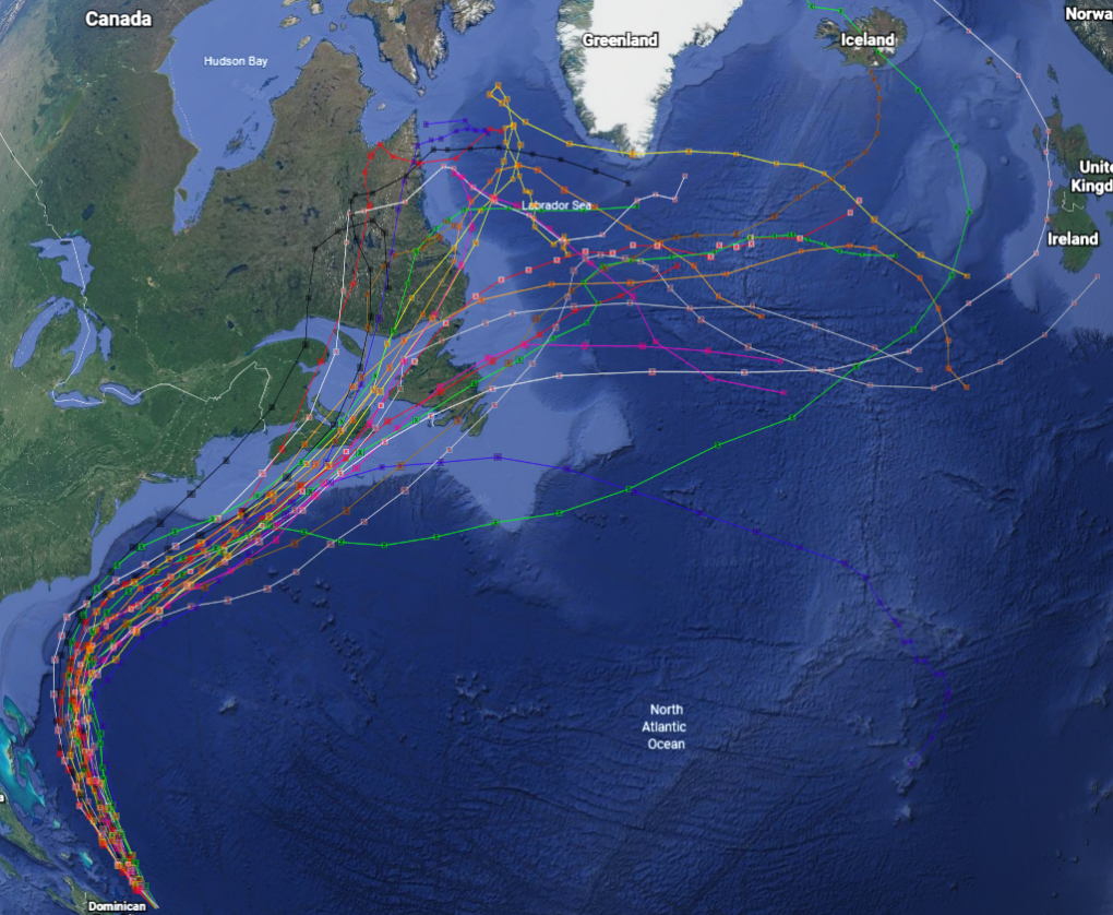
GRIP Hurricane and Tropical Storm Forecasts V1
National Aeronautics and Space Administration —
The GRIP Hurricane and Tropical Storm Forecasts dataset consists of tropical cyclone model forecast tracks archived during the NASA Genesis and Rapid Intensification... -
City
SMART Bus Route 2017
City of Ferndale, Michigan —
Most current available data on Suburban Mobility Authority for Regional Transportation (SMART) bus routes in the Tri-County area of Southeast Michigan.Click here for...

Official websites use .gov
A
.gov website belongs to an official government
organization in the United States.
Secure .gov websites use HTTPS
A
lock (
) or https:// means you’ve safely connected to
the .gov website. Share sensitive information only on official,
secure websites.