

9 datasets found for "TRI"
-
Federal
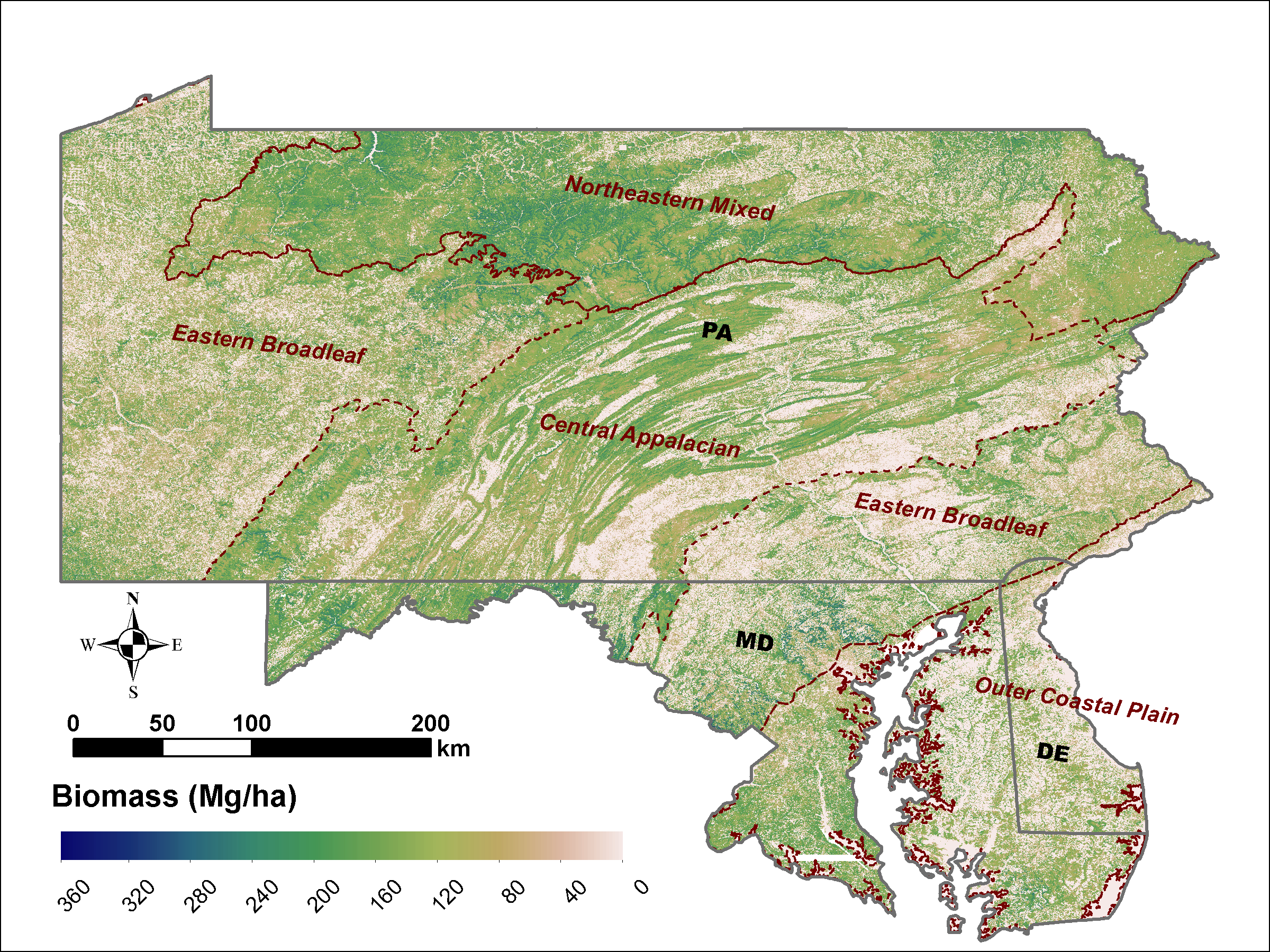
LiDAR Derived Biomass, Canopy Height and Cover for Tri-State (MD, PA, DE) Region, V2
National Aeronautics and Space Administration —
This dataset provides 30-meter gridded estimates of aboveground biomass (AGB), forest canopy height, and canopy coverage for Maryland, Pennsylvania, and Delaware in... -
Federal
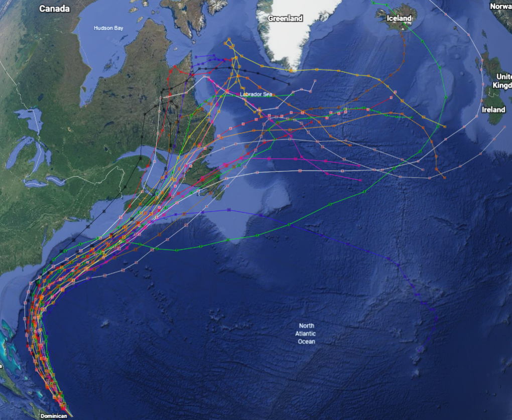
GRIP Hurricane and Tropical Storm Forecasts V1
National Aeronautics and Space Administration —
The GRIP Hurricane and Tropical Storm Forecasts dataset consists of tropical cyclone model forecast tracks archived during the NASA Genesis and Rapid Intensification... -
Federal
First ISCCP Regional Experiment (FIRE) Cirrus Phase II Colorado State University (CSU) Station 2 Data
National Aeronautics and Space Administration —
The First ISCCP Regional Experiments have been designed to improve data products and cloud/radiation parameterizations used in general circulation models (GCMs).... -
Federal
LBA-ECO LC-02 Hot Pixel Fire Indicator Data for Tri-national MAP Region: 2003-2006 NGDA
National Aeronautics and Space Administration —
This data set provides hot pixel data, as an indicator of fires, that were detected by various satellites in the tri-national MAP region (Madre de Dios-Peru, Acre-... -
Federal
NPP Grassland: Tumentsogt, Mongolia, 1982-1990, R1
National Aeronautics and Space Administration —
This data set provides two data files in text format (.txt). One file contains tri-monthly measurements of above-ground biomass made during the growing season between... -
Federal
ABoVE: Dall Sheep Response to Snow and Landscape Covariates, Alaska, 2005-2008 NGDA
National Aeronautics and Space Administration —
This dataset provides daily estimates of snow depth and snow density for the study area in Lake Clark National Park and Preserve (LCNPP), Alaska. The data were... -
Federal
LBA-ECO LC-02 Tributary Coordinates, Acre River, Tri-national River Basin: 2003-2004
National Aeronautics and Space Administration —
This data set provides coordinates for points at the mouth of tributaries of the Acre River in the Tri-national River Basin in South America. Three Global Positioning... -
Federal
First ISCCP Regional Experiment (FIRE) Cirrus 1 Surface Radiation Budget (SRB) Shortwave Radiation Data
National Aeronautics and Space Administration —
These data contain down-welled global shortwave hemispherical radiation taken during the Wisconsin FIRE/SRB experiment. The data set consists of measurement\ s taken... -
Federal
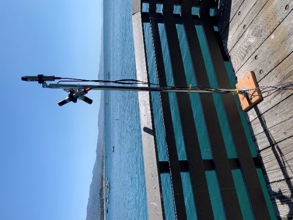
SHIFT: Ramses Trios Radiometer Above Water Measurements, Santa Barbara Sea, CA
National Aeronautics and Space Administration —
This dataset provides calculated remote sensing reflectance (Rrs) from measurements collected with a Ramses TriOS radiometer deployed on the Santa Barbara Museum of...
9 datasets found for "TRI"