
-
Federal
Global Maps of Atmospheric Nitrogen Deposition, 1860, 1993, and 2050
National Aeronautics and Space Administration —
This data set provides global gridded estimates of atmospheric deposition of total inorganic nitrogen (N), NHx (NH3 and NH4+), and NOy (all oxidized forms of nitrogen... -
Federal
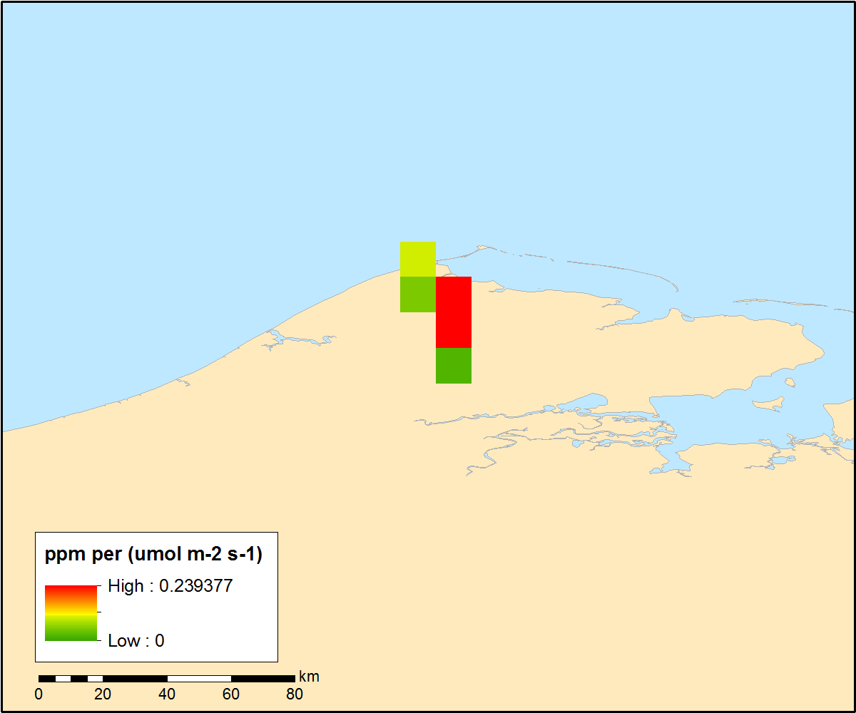
Pre-ABoVE: Particle Trajectories for WRF-STILT Model, Barrow, AK, 1982-2011
National Aeronautics and Space Administration —
This dataset provides Stochastic Time-Inverted Lagrangian Transport model outputs for receptors located at the NOAA Barrow Alaska Observatory for 12 selected years... -
Federal
ACT-America: L2 In Situ Atmospheric CO2, CO, CH4, and O3 Concentrations, Eastern USA
National Aeronautics and Space Administration —
This dataset provides atmospheric carbon dioxide (CO2), carbon monoxide (CO), methane (CH4), water vapor (H2O), and ozone (O3) concentrations collected during... -
Federal
Pre-ABoVE: Gridded Footprints from WRF-STILT Model, Barrow, Alaska, 1982-2011
National Aeronautics and Space Administration —
This dataset provides Stochastic Time-Inverted Lagrangian Transport model outputs for receptors located at the NOAA Barrow Alaska Observatory for 12 selected years... -
Federal
ACT-America: L2 Remotely Sensed Column-avg CO2 by Airborne Lidar, Lite, Eastern USA
National Aeronautics and Space Administration —
This dataset provides a direct subset (i.e., the Lite version) of the Level 2 (L2) remotely sensed column-average carbon dioxide (CO2) concentrations measured during... -
Federal
ACT-America: L2 In Situ Atmospheric Gas Concentrations from Flasks, Eastern USA
National Aeronautics and Space Administration —
This dataset provides atmospheric carbon dioxide (CO2), methane (CH4), carbon monoxide (CO), molecular hydrogen (H2), nitrous oxide (N2O), sulfur hexafluoride (SF6),... -
Federal
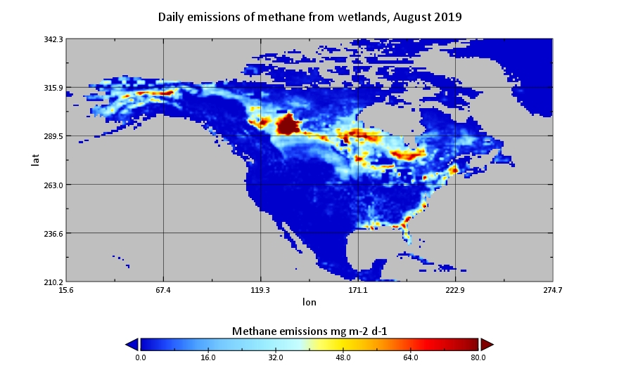
CMS: Global 0.5-deg Wetland Methane Emissions and Uncertainty (WetCHARTs v1.3.1)
National Aeronautics and Space Administration —
This dataset provides global monthly wetland methane (CH4) emissions estimates at 0.5 by 0.5-degree resolution for the period 2001-2019 that were derived from an... -
Federal
Vulcan: High-Resolution Annual Fossil Fuel CO2 Emissions in USA, 2010-2015, Version 3
National Aeronautics and Space Administration —
The Vulcan version 3.0 annual dataset provides estimates of annual carbon dioxide (CO2) emissions from the combustion of fossil fuels (FF) and CO2 emissions from... -
Federal
ACT-America: L1 Raw, Uncalibrated In-Situ CO2, CO, and CH4 Mole Fractions from Towers
National Aeronautics and Space Administration —
This dataset provides Level 1 (L1) in situ atmospheric carbon dioxide (CO2), carbon monoxide (CO), and methane (CH4) concentrations as measured on a network of... -
Federal
CARVE: Ecosystem Scale CH4 Emission Derived from Aircraft Observations 2012-2014
National Aeronautics and Space Administration —
This dataset provides methane flux estimates derived from airborne measurements collected over Alaska and the western Yukon Territory during the Carbon in Arctic... -
Federal
CARVE: CH4, CO2, and CO Atmospheric Concentrations, CARVE Tower, Alaska, 2012-2014
National Aeronautics and Space Administration —
This data set provides hourly atmospheric concentrations of methane (CH4), carbon dioxide (CO2), and carbon monoxide (CO) as mole fractions, from January 2012 to... -
Federal
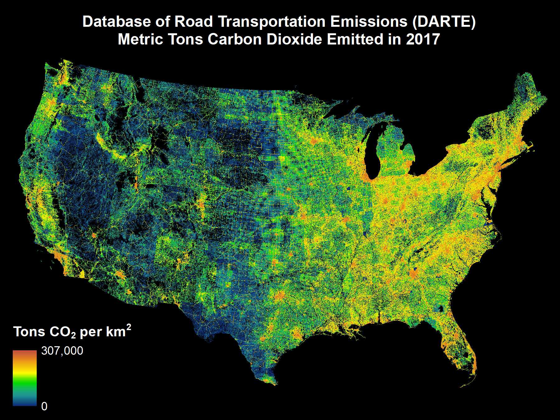
DARTE Annual On-road CO2 Emissions on a 1-km Grid, Conterminous USA, V2, 1980-2017
National Aeronautics and Space Administration —
This data set provides a 38-year, 1-km resolution inventory of annual on-road CO2 emissions for the conterminous United States based on roadway-level vehicle traffic... -
Federal
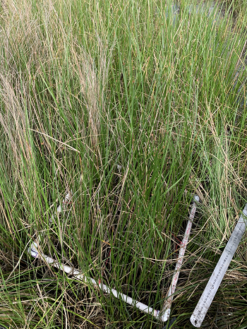
Delta-X: Aboveground Biomass and Necromass across Wetlands, MRD, Louisiana, 2021, V2
National Aeronautics and Space Administration —
This dataset contains total aboveground biomass (AGB) and necromass (AGN), and total carbon, total nitrogen, and total phosphorus content of aboveground biomass (AGB)... -
Federal
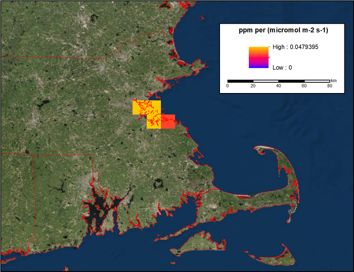
WRF-STILT Gridded Footprints for Boston, MA, USA, 2013-2014
National Aeronautics and Space Administration —
This dataset provides Weather Research and Forecasting (WRF) Stochastic Time-Inverted Lagrangian Transport (STILT) footprint data products for two receptors located... -
Federal
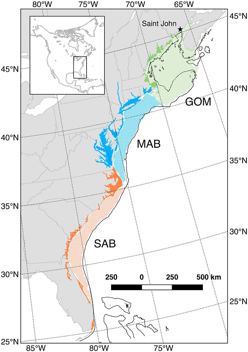
Mean Annual Fluxes of Carbon in Coastal Ecosystems of Eastern North America
National Aeronautics and Space Administration —
This dataset contains best estimates and uncertainties for mean annual fluxes of inorganic, organic, and total (organic + inorganic) carbon in tidal wetlands,... -
Federal
ACT-America: Profile-based Planetary Boundary Layer Heights, Eastern USA
National Aeronautics and Space Administration —
This dataset provides profile-based estimates of the height to the top of the planetary boundary layer (PBL), also known as the atmospheric boundary layer (ABL), in... -
Federal
LBA-ECO LC-02 Hot Pixel Fire Indicator Data for Tri-national MAP Region: 2003-2006 NGDA
National Aeronautics and Space Administration —
This data set provides hot pixel data, as an indicator of fires, that were detected by various satellites in the tri-national MAP region (Madre de Dios-Peru, Acre-... -
Federal
CARVE: L4 Gridded Footprints from WRF-STILT model, 2012-2016
National Aeronautics and Space Administration —
This data set provides Weather Research and Forecasting (WRF) Stochastic Time-Inverted Lagrangian Transport (STILT) Footprint data products for particle receptors... -
Federal
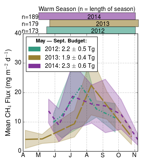
CARVE-ARCSS: Methane Loss From Arctic- Fluxes From the Alaskan North Slope, 2012-2014
National Aeronautics and Space Administration —
This data set provides the results of (1) year-round measurements of methane (CH4) flux along with soil and air temperatures at five eddy covariance towers at sites... -
Federal
Surface Water Elevation and Quality, Peace-Athabasca Delta, Canada, 2006-2007
National Aeronautics and Space Administration —
The Peace-Athabasca Delta (PAD) is a large boreal wetland located in northeastern Alberta, Canada at the confluence of the Peace and Athabasca Rivers with Lake...

Official websites use .gov
A
.gov website belongs to an official government
organization in the United States.
Secure .gov websites use HTTPS
A
lock (
) or https:// means you’ve safely connected to
the .gov website. Share sensitive information only on official,
secure websites.