

37 datasets found
-
Federal
2023 National Offshore Wind data set (NOW-23) 18 recent views
Department of Energy —
The 2023 National Offshore Wind data set (NOW-23) is the latest wind resource data set for offshore regions in the United States, which supersedes, for its offshore... -
Federal
GOOML Big Kahuna Forecast Modeling and Genetic Optimization Files
Department of Energy —
This submission includes example files associated with the Geothermal Operational Optimization using Machine Learning (GOOML) Big Kahuna fictional power plant, which... -
Federal
EGS Collab Experiment 2: Core Logs
Department of Energy —
Core logs and photos from the EGS Collab project Experiment 2 for the Top Vertical well (TV4100) and the Top Horizontal well (TV 4100) on the 4100 Level of SURF (the... -
Federal
EGS Collab Experiment 2: Preliminary Test Wells Locations and Orientations
Department of Energy —
The EGS Collab project is evaluating a site for Experiment 2 (hydraulic fracturing/shearing) at a depth of 1.25 km in the Sanford Underground Research Facility (SURF)... -
Federal
EGS Collab Experiment 2: Laser Scanned 4100 L Drift Map
Department of Energy —
The EGS Collab project is evaluating a site for Experiment 2 (hydraulic fracturing/shearing) at a depth of 1.25 km in the Sanford Underground Research Facility (SURF)... -
Federal
Natural Reservoir Analysis in Low-Temperature Geothermal Play Fairway Analysis for the Appalachian Basin
Department of Energy —
The files included in this submission contain all data pertinent to the methods and results of this task's output, which is a cohesive multi-state map of all known... -
Federal
Fallon FORGE: Vs30m Seismic Velocity
Department of Energy —
Time-averaged shear-wave velocity to 30 m depth about the Fallon, NV FORGE site. -
Federal
Conductance Steamflow Relationship
Department of Energy —
These histograms represent our calibration of conductance of a volcanic geothermal field (with a clay cap) and the observed steam flow rates. Darajat is a vapor... -
Federal
Snake River Plain Geothermal Play Fairway Analysis Project Active Source Seismic Data
Department of Energy —
This archive contains seismic shot field records for 10 profiles located in Camas Prairie, Idaho. The eight numbered .sgy files were acquired using a seismic land... -
Federal
USU Camas-1 Test Well: Documentation
Department of Energy —
This submission contains documents that describe the USU Camas-1 test well, drilled in Camas Prairie, Idaho, in Fall 2018 and Fall 2019. The purpose of this well is... -
Federal
Project HOTSPOT: Mountain Home Well Core and Drill Site Photos
Department of Energy —
The Snake River Plain (SRP), Idaho, hosts potential geothermal resources due to elevated groundwater temperatures associated with the thermal anomaly Yellowstone-... -
Federal
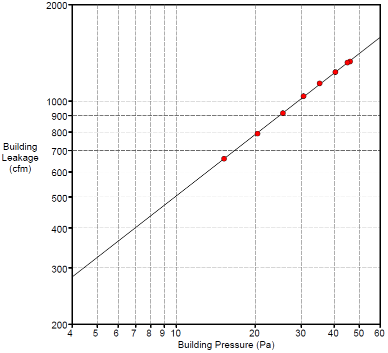
Field Testing of Compartmentalization Methods for Multifamily Construction - Washington DC
Department of Energy —
BSC TO5 Task 2.1 Field Testing of Compartmentalization Methods for Multifamily Construction - Capitol Heights, MD 20743 A building comprising five vertical townhome... -
Federal
Utah FORGE: Seismic Velocity Models, February 2021
Department of Energy —
This dataset contains a map, showing the Utah FORGE seismic stations, and seismic velocity model data. There are 61 1-D velocity models which are in a compressed TAR... -
Federal
Tidal Resource Data from Sequim Bay Inlet, WA, August 2020
Department of Energy —
Data from a Nortek Signature1000 deployed on a lander for 14 days in Aug 2020 in the entrance to Sequim Bay, WA. Raw data were processed using the DOLfYN python... -
Federal
Bradys Hot Springs Geothermal Area Build FEM Configuration
Department of Energy —
This submission contains mesh information, nodal coordinates, connectivity data, and list of query points for the build FEM configuration. -
Federal
ALFA Coupled Computational Fluid Dynamics/Discrete Element Method Modeling System
Department of Energy —
The HDIS/COUPi discrete element method modeling system was used to simulate the interaction between various debris and the Research Debris Diversion Platform (RDDP) -
Federal
Snake River Plain Geothermal Play Fairway Analysis Heat, Permeability, and Seal CRS Map Raster Files
Department of Energy —
Snake River Plain Play Fairway Analysis - Phase 1 CRS Raster Files. This dataset contains raster files created in ArcGIS. These raster images depict Common Risk... -
Federal
Deep Direct-Use Feasibility Study Temperature-Depth Estimates for West Virginia University, Morgantown, WV
Department of Energy —
This dataset contains data spreadsheets and figures that summarize the results of a stochastic analysis of temperatures at depth below the West Virginia University... -
Federal
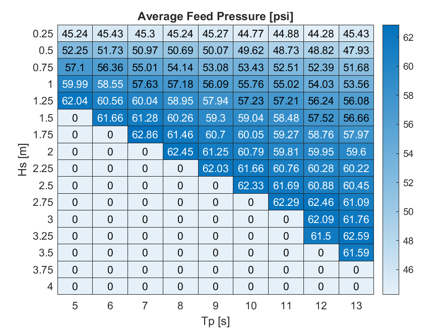
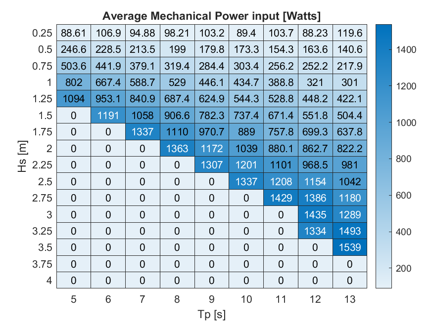
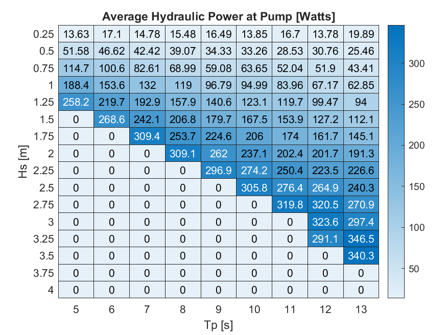
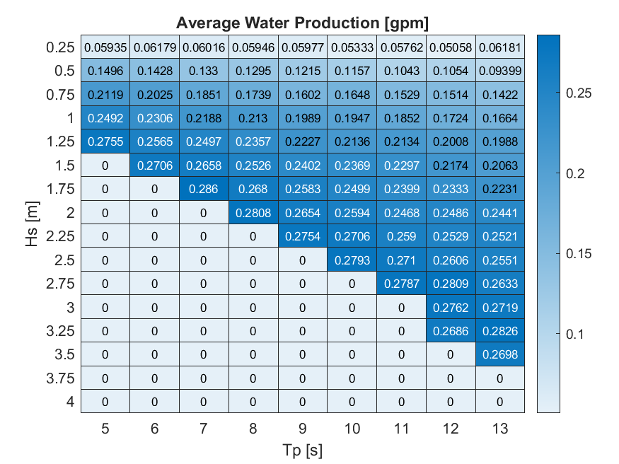
HERO WEC V1.0 - WEC-Sim Detailed Simulation Runs and Summary Data
Department of Energy —
Data sets from simulation runs include 144 wave cases that were run based on the WEC-Sim model (https://mhkdr.openei.org/submissions/483). The 144 wave cases...
37 datasets found