
-
NASA Financial Budget Documents, Strategic Plans and Performance Reports 2016: NASA Budget Estimates recent views
NASA Financial Budget Documents, Strategic Plans and Performance Reports for fiscal year 2016. -
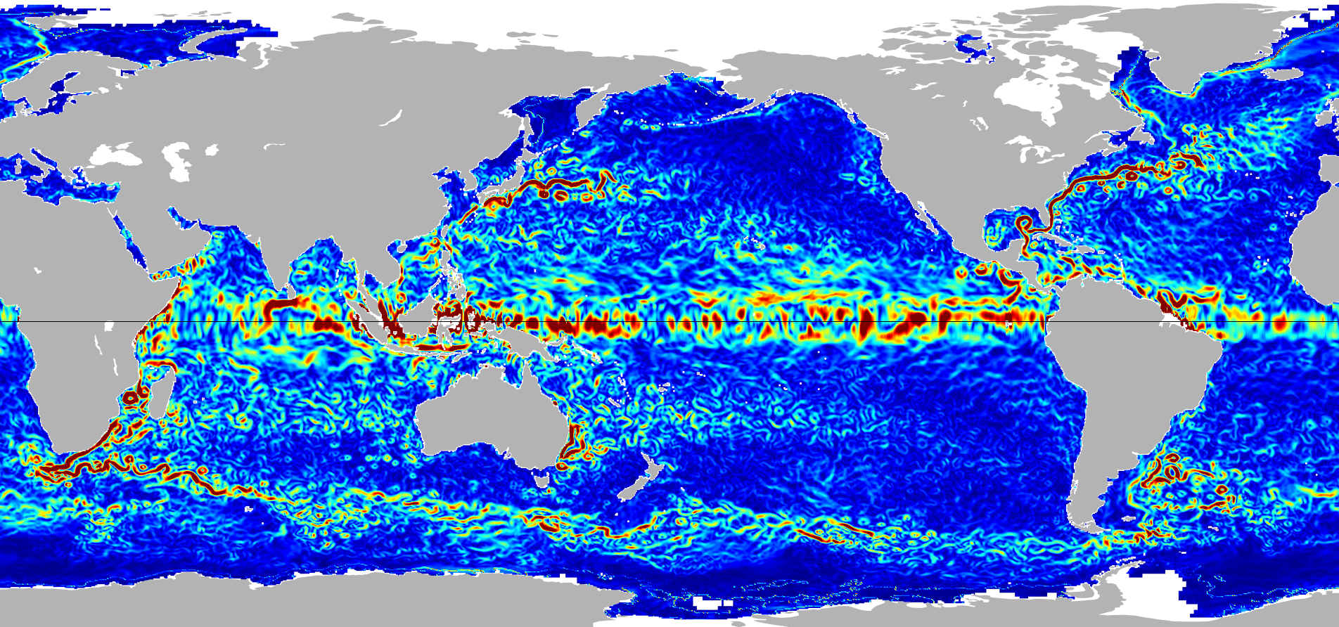
Ocean Surface Current Analyses Real-time (OSCAR) Surface Currents - Near Real Time 0.25 Degree (Version 2.0) recent views
Ocean Surface Current Analyses Real-time (OSCAR) is a global surface current database and NASA funded research project. OSCAR ocean mixed layer velocities are calculated from... -
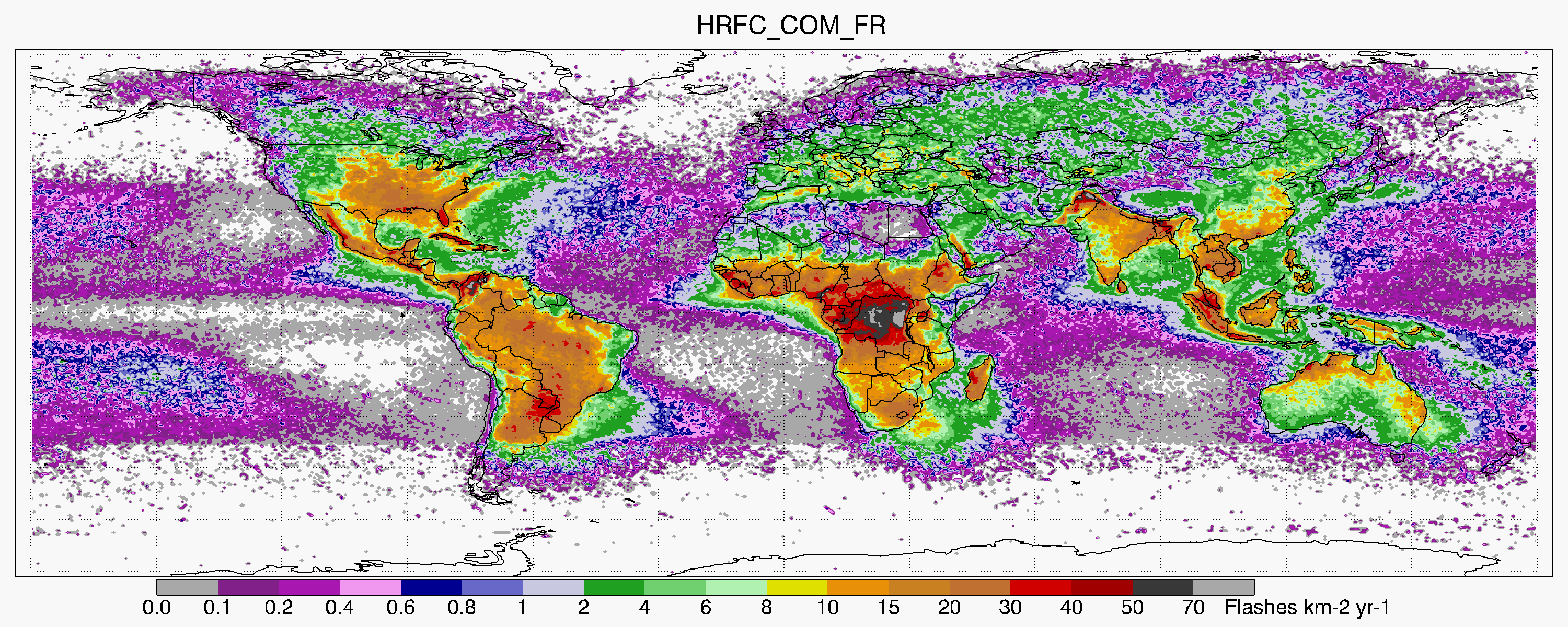
LIS/OTD 0.5 Degree High Resolution Full Climatology (HRFC) V2.3.2015 recent views
The LIS/OTD 0.5 Degree High Resolution Full Climatology (HRFC) contains a variety of gridded climatologies of total lightning flash rates obtained from two lightning detection... -
Analysis of Virtual Sensors for Predicting Aircraft Fuel Consumption recent views
Previous research described the use of machine learning algorithms to predict aircraft fuel consumption. This technique, known as Virtual Sensors, models fuel consumption as a... -
ISLSCP II EDGAR 3 Gridded Greenhouse and Ozone Precursor Gas Emissions recent views
The EDGAR (Emission Database for Global Atmospheric Research) database project is a comprehensive task carried out jointly by the National Institute for Public Health (RIVM) and... -
NASA Financial Budget Documents, Strategic Plans and Performance Reports 2016: NASA Budget Fact Sheet recent views
NASA Financial Budget Documents, Strategic Plans and Performance Reports for fiscal year 2016. -
Pseudo-Label Generation for Multi-Label Text Classification recent views
With the advent and expansion of social networking, the amount of generated text data has seen a sharp increase. In order to handle such a huge volume of text data, new and... -
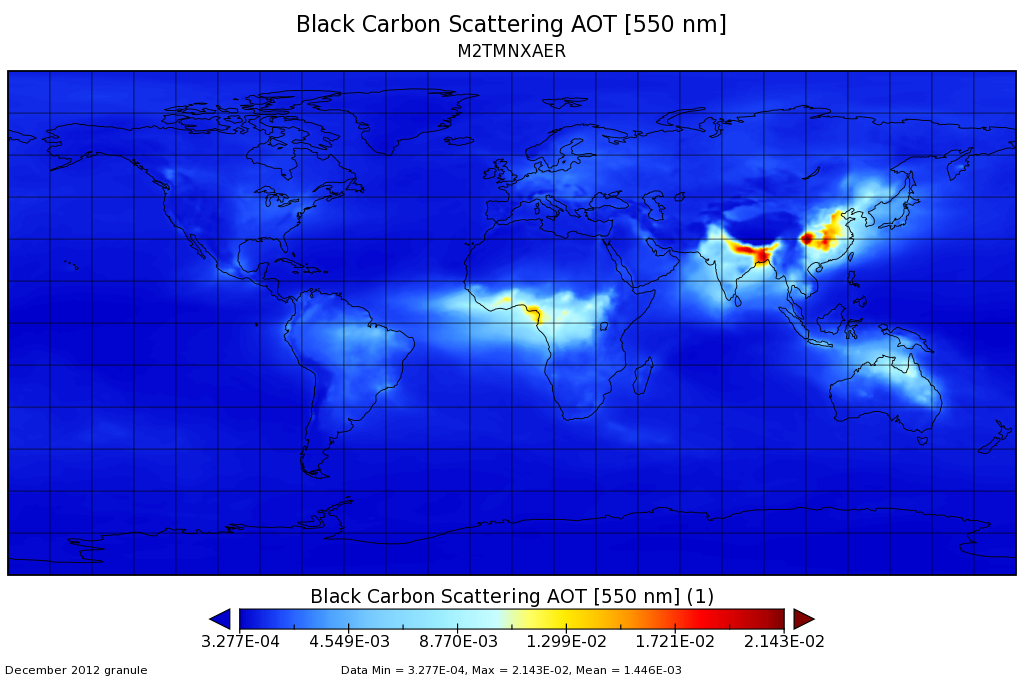
MERRA-2 tavgM_2d_aer_Nx: 2d,Monthly mean,Time-averaged,Single-Level,Assimilation,Aerosol Diagnostics 0.625 x 0.5 degree V5.12.4 (M2TMNXAER) at GES DISC recent views
M2TMNXAER (or tavgM_2d_aer_Nx) is a time-averaged 2-dimensional monthly mean data collection in Modern-Era Retrospective analysis for Research and Applications version 2... -
NLDAS Secondary Forcing Data L4 Hourly 0.125 x 0.125 degree V2.0 (NLDAS_FORB0125_H) at GES DISC recent views
This data set contains the secondary forcing hourly data "File B" for Phase 2 of the North American Land Data Assimilation System (NLDAS-2). The data are in 1/8th degree grid... -
GPM IMERG Early Precipitation L3 1 day 0.1 degree x 0.1 degree V06 (GPM_3IMERGDE) at GES DISC recent views
The Integrated Multi-satellitE Retrievals for GPM (IMERG) is the unified U.S. algorithm that provides the multi-satellite precipitation product for the U.S. GPM team. Version 06... -
GLDAS Catchment Land Surface Model L4 daily 0.25 x 0.25 degree GRACE-DA1 V2.2 (GLDAS_CLSM025_DA1_D) at GES DISC recent views
NASA Global Land Data Assimilation System Version 2 (GLDAS-2) has three components: GLDAS-2.0, GLDAS-2.1, and GLDAS-2.2. GLDAS-2.0 is forced entirely with the Princeton... -
Anomaly Detection in a Fleet of Systems recent views
A fleet is a group of systems (e.g., cars, aircraft) that are designed and manufactured the same way and are intended to be used the same way. For example, a fleet of delivery... -
OMPS-NPP L1G LP Radiance EV Wavelength-Altitude Grid swath orbital 3slit V2.6 (OMPS_NPP_LP_L1G_EV) at GES DISC recent views
The OMPS-NPP L1G LP Radiance EV Wavelength-Altitude Grid swath orbital 3slit product contains the calibrated earth-viewing radiances measured by the Ozone Mapping and Profiling... -
A Survey of Artificial Intelligence for Prognostics recent views
Integrated Systems Health Management includes as key elements fault detection, fault diagnostics, and failure prognostics. Whereas fault detection and diagnostics have been the... -
Estimation of Faults in DC Electrical Power System recent views
This paper demonstrates a novel optimizationbased approach to estimating fault states in a DC power system. The model includes faults changing the circuit topology along with... -
CALIPSO Lidar Level 1B profile data, V4-10 recent views
CAL_LID_L1-Standard-V4-10 is the Cloud-Aerosol Lidar and Infrared Pathfinder Satellite Observation (CALIPSO) Lidar Level 1B profile data, Version 4-10 data product. This data... -
MISR Geometric Parameters V003 recent views
MIB2GEOP_003 is the Multi-angle Imaging SpectroRadiometer (MISR) Geometric Parameters Version 3 product. It contains the Geometric Parameters which measure the sun and view... -
MERRA-2 inst6_3d_ana_Nv: 3d,6-Hourly,Instantaneous,Model-Level,Analysis,Analyzed Meteorological Fields 0.625 x 0.5 degree V5.12.4 (M2I6NVANA) at GES DISC recent views
M2I6NVANA (or inst6_3d_ana_Nv) is an instantaneous 3-dimensional 6-hourly data collection in Modern-Era Retrospective analysis for Research and Applications version 2 (MERRA-2).... -
Global Aboveground and Belowground Biomass Carbon Density Maps for the Year 2010 recent views
This dataset provides temporally consistent and harmonized global maps of aboveground and belowground biomass carbon density for the year 2010 at a 300-m spatial resolution. The... -
High Resolution Global Contiguous SIF Estimates from OCO-2 SIF and MODIS, Version 2 NGDA recent views
This dataset provides spatially-contiguous global mean daily solar-induced chlorophyll fluorescence (SIF) estimates at 0.05 degree (approximately 5 km at the equator) spatial...

Official websites use .gov
A
.gov website belongs to an official government
organization in the United States.
Secure .gov websites use HTTPS
A
lock (
) or https:// means you’ve safely connected to
the .gov website. Share sensitive information only on official,
secure websites.