
-
Monthly Frequency of Dust Storm over Land for Varying Intensities, Based on MODIS Aqua Deep Blue Level 2 Aerosol Products MYD04_L2 Collection 6.1, on a Global 0.1 by 0.1 Degree Grid, Level 3 Version 1 (MYDFDS_MON_GLB_L3) at GES DISC
Version 1 is the current version of the dataset.This collection MYDFDS_MON_GLB_L3 provides level 3 monthly frequency of dust storms (FDS) over land from 175°W to 175°E and 80°S... -
CAR ARCTAS BRDF Measurements V2 (CAR_ARCTAS_BRDF) at GES DISC
ARCTAS focuses on advancing understanding of the factors driving current changes in the Arctic region including transport of mid-latitude pollution, boreal forest fires, aerosol... -
CAR CLAMS BRDF Measurements V2 (CAR_CLAMS_BRDF) at GES DISC
CLAMS is the Chesapeake Lighthouse and Aircraft Measurements for Satellites field campaign sponsored by CERES, MISR, MODIS-Atmospheres and the NASA/GEWEX Global Aerosol... -
MLS/Aura Level 2 Diagnostics, Geophysical Parameter Grid V005 (ML2DGG) at GES DISC
ML2DGG is the EOS Aura Microwave Limb Sounder (MLS) product containing geophysical diagnostic quantities pertaining directly to the standard geophysical data products, generally... -
OMPS-NPP L2 NP Ozone (O3) Vertical Profile swath orbital
The OMPS-NPP L2 NP Ozone (O3) Total Column swath orbital product provides ozone profile retrievals from the Ozone Mapping and Profiling Suite (OMPS) Nadir-Profiler (NP)... -
MLS/Aura Level 2 Diagnostics, Miscellaneous Grid V004 (ML2DGM) at GES DISC
ML2DGM is the EOS Aura Microwave Limb Sounder (MLS) product containing the minor frame diagnostic quantities on a miscellaneous grid. These include items such as tangent... -
MLS/Aura L1 Radiances from Filter Banks for THz V004 (ML1RADT) at GES DISC
ML1RADT is the EOS Aura Microwave Limb Sounder (MLS) product containing the level 1 radiances from the filter banks for the GHz radiometers. The data version is 4.2. Data... -
OMPS-NPP L2 LP Ozone (O3) Vertical Profile swath daily Center slit V2.6 (OMPS_NPP_LP_L2_O3_DAILY) at GES DISC
Version 2.6 is the current version of this data product, and supersedes all previous versions.The OMPS-NPP L2 LP Ozone (O3) Vertical Profile swath daily Center slit collection... -
OMPS-NPP L2 NM Ozone (O3) Total Column swath orbital
The OMPS-NPP L2 NM Ozone (O3) Total Column swath orbital product provides total ozone measurements from the Ozone Mapping and Profiling Suite (OMPS) Nadir-Mapper (NM) instrument... -
Sounder SIPS: Suomi NPP CrIMSS Level 3 Specific Quality Control Gridded Daily SiFSAP V2 (SNDRSNIML3SDSFSP) at GES DISC
The SIFSAP (Single Field-of-View Sounder Atmospheric Products) algorithm provides retrieval for each sounder Field of View (FOV), therefore, it has 3-times higher horizontal... -
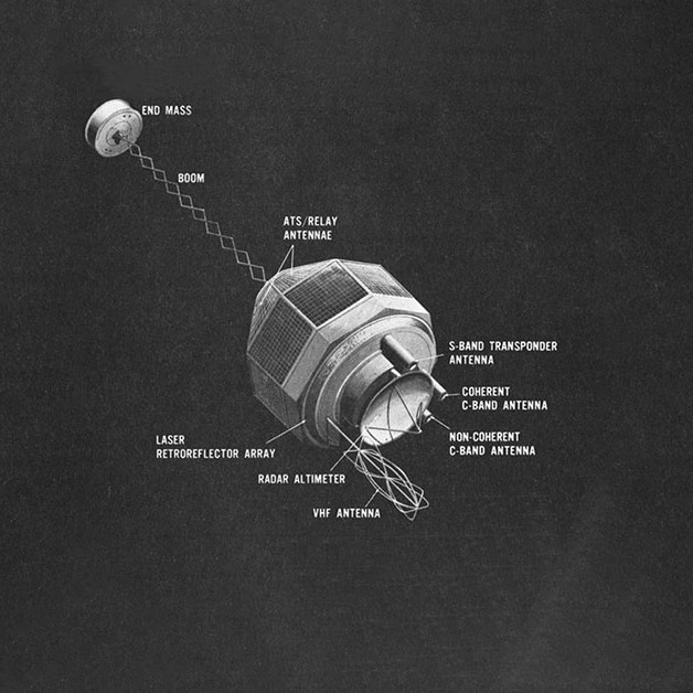
GEOS-3 Satellite-to-Satellite Tracking Data V001 (GEOS3STST) at GES DISC
GEOS3STST is the satellite-to-satellite tracking data product which contains observations, obtained from the S-band transponders on GEOS 3 relayed by the ATS 6 spacecraft to... -
Eole 1 Raw Temperature, Pressure and Location Data Near 200 mbar (EOLE1) at GES DISC
The Eole 1 Raw Temperature, Pressure and Location Data Near 200 mbar product was obtained from the experimenter and originally consisted of a BCD tape generated on a CDC 6600... -
Climatological Monthly Frequency of Dust Storm over Land for Varying Intensities, Based on MODIS Terra Deep Blue Level 2 Aerosol Products MOD04_L2 Collection 6.1, on a Global 0.1 by 0.1 Degree Grid, Level 3 Version 1 (MODFDS_CLM_GLB_L3) at GES DISC
Version 1 is the current version of the dataset.This collection MODFDS_CLM_GLB_L3 provides level 3 climatological monthly frequency of dust storms (FDS) over land from 175°W to... -
CAR LEADEX Arctic Sea Ice and Tundra BRDF Measurements L1 V2 (CAR_LEADEX_BRDF) at GES DISC
CAR LEADEX mission measured bidirectional reflectance functions for four common arctic surfaces: snow covered sea ice, melt season sea ice, snow covered tundra, and tundra...

Official websites use .gov
A
.gov website belongs to an official government
organization in the United States.
Secure .gov websites use HTTPS
A
lock (
) or https:// means you’ve safely connected to
the .gov website. Share sensitive information only on official,
secure websites.