
-
Global Land Cover Characterization Program recent views
The Global Land Cover Characterization Project was established to meet science data requirements identified by the International Geosphere and Biosphere Programme (IGBP), and... -
USGS Digital Orthophoto Quadrangles recent views
A Digital Orthophoto Quadrangle (DOQ) is a computer-generated image of an aerial photograph in which the image displacement caused by terrain relief and camera tilt has been... -
CLPX-Ground: ISA Snow Pit Measurements, Version 2 recent views
This data set consists of snow pit data from nine study areas, within three larger-scale areas in northern Colorado (Fraser, North Park, and Rabbit Ears Meso-cell Study Areas... -
ASTER Global Water Bodies Database V001 NGDA recent views
The ASTER Global Water Bodies Database (ASTWBD) Version 1 data product provides global coverage of water bodies larger than 0.2 square kilometers at a spatial resolution of 1... -
MERRA-2 tavg1_2d_flx_Nx: 2d,1-Hourly,Time-Averaged,Single-Level,Assimilation,Surface Flux Diagnostics 0.625 x 0.5 degree V5.12.4 (M2T1NXFLX) at GES DISC recent views
M2T1NXFLX (or tavg1_2d_flx_Nx) is an hourly time-averaged 2-dimensional data collection in Modern-Era Retrospective analysis for Research and Applications version 2 (MERRA-2).... -
ASTER Global Digital Elevation Model NetCDF V003 NGDA recent views
The ASTER Global Digital Elevation Model (GDEM) Version 3 (ASTGTM) provides a global digital elevation model (DEM) of land areas on Earth at a spatial resolution of 1 arc second... -
SENTINEL-1B_SINGLE_POL_GRD_HIGH_RES recent views
Sentinel-1B Single-pol ground projected high and full resolution images -
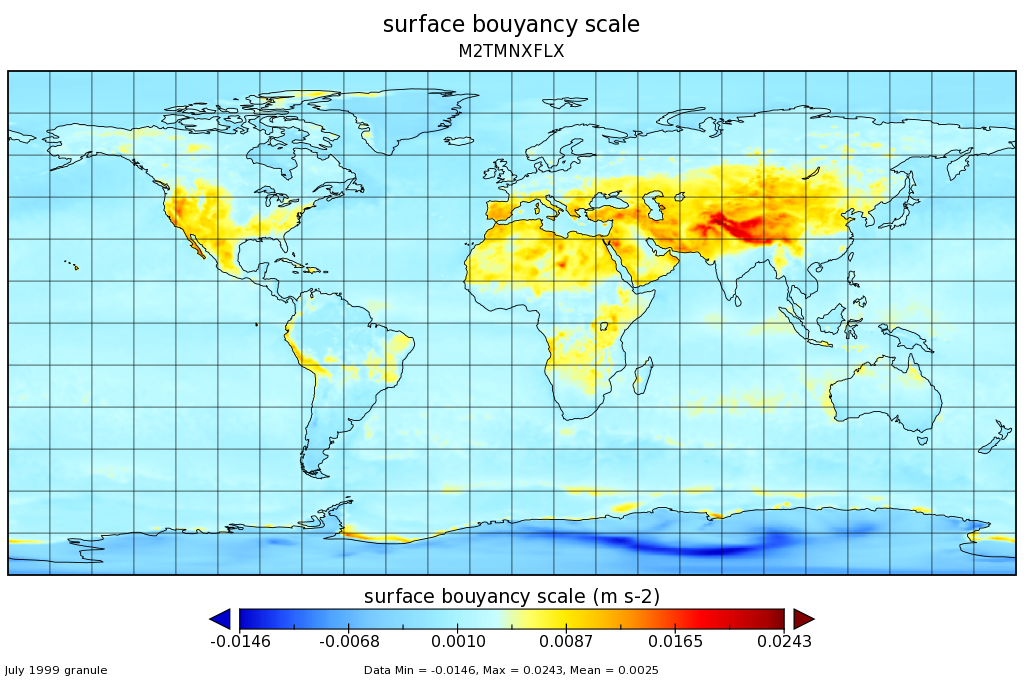
MERRA-2 tavgM_2d_flx_Nx: 2d,Monthly mean,Time-Averaged,Single-Level,Assimilation,Surface Flux Diagnostics 0.625 x 0.5 degree V5.12.4 (M2TMNXFLX) at GES DISC recent views
M2TMNXFLX (or tavgM_2d_flx_Nx) is a time-averaged 2-dimensional monthly mean data collection in Modern-Era Retrospective analysis for Research and Applications version 2... -
LBA-ECO CD-06 Biogeochemistry of Ji-Parana River and Tributaries, Brazil: 1999-2003 recent views
This data set provides spatially extensive and temporally intensive surveys of the river biogeochemistry of the Ji-Parana River Basin in Western Amazonia, Rondonia, Brazil. The... -
SENTINEL-1A_SINGLE_POL_GRD_FULL_RES recent views
Sentinel-1A Single-pol ground range detected full resolution images -
SENTINEL-1B_DUAL_POL_GRD_MEDIUM_RES recent views
Sentinel-1B Dual-pol ground projected medium resolution images -
LBA-ECO ND-01 Watershed Deforestation from Landsat TM Series, Rondonia, Brazil: 1999 recent views
This data set provides estimates of watershed deforestation, as a proportion of the total area of watersheds, in Rondonia, Brazil for 1999. Deforestation maps were determined... -
Space Acquired Photography recent views
Gemini photography was acquired between March 23, 1965 and November 15, 1966. The images were collected as part of the Synoptic Terrain Photography and the Synoptic Weather... -
Maps of Vegetation Types and Physiographic Features, Kuparuk River Basin, Alaska recent views
This data set provides a collection of vegetation, landscape, geobotanical, elevation, hydrology, and geologic maps for the Kuparuk River Basin, North Slope, Alaska. The maps...

Official websites use .gov
A
.gov website belongs to an official government
organization in the United States.
Secure .gov websites use HTTPS
A
lock (
) or https:// means you’ve safely connected to
the .gov website. Share sensitive information only on official,
secure websites.