
-
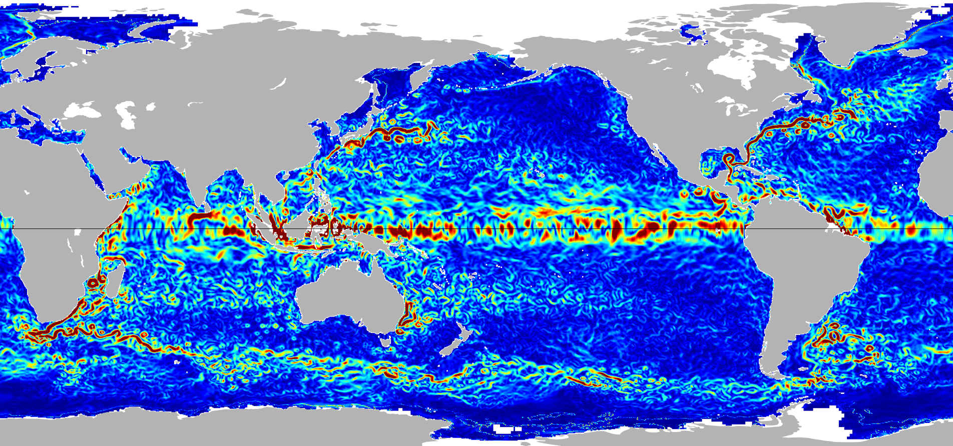
Ocean Surface Current Analyses Real-time (OSCAR) Surface Currents - Final 0.25 Degree (Version 2.0) recent views
Ocean Surface Current Analyses Real-time (OSCAR) is a global surface current database and NASA funded research project. OSCAR ocean mixed layer velocities are calculated from... -
Ocean Surface Current Analyses Real-time (OSCAR) Surface Currents - Near Real Time 0.25 Degree (Version 2.0) recent views
Ocean Surface Current Analyses Real-time (OSCAR) is a global surface current database and NASA funded research project. OSCAR ocean mixed layer velocities are calculated from... -
CYGNSS Level 3 MRG Science Data Record Near Real Time Version 3.2.1 recent views
This dataset contains the version 3.2.1 CYGNSS Level 3 Merged (MRG) Science Data Record Near Real Time (NRT) Storm Wind Speed derived from the Delay Doppler Mapping Instrument... -
Jason-1 SGDR version E NetCDF recent views
The Sensory Geophysical Data Record (SGDR) files contain full accuracy altimeter data, with a high precision orbit (accuracy ~1.5 cm). The instruments on Jason-1 make direct... -
Aquarius Official Release Level 3 Sea Surface Salinity Standard Mapped Image Descending Daily Data V5.0 recent views
Aquarius Level 3 sea surface salinity (SSS) standard mapped image data contains gridded 1 degree spatial resolution SSS averaged over daily, 7 day, monthly, and seasonal time... -
SPURS-2 shipboard X-band radar backscatter images for the 2016 E. Tropical Pacific field campaign recent views
The SPURS-2 X-band marine navigation radar image dataset was collected from the ship during both the 2016 and 2017 cruises. The dataset consists of screenshots of rain echoes... -
ECCO Gent-McWilliams Ocean Bolus Velocity - Daily Mean llc90 Grid (Version 4 Release 4) recent views
This dataset provides daily-averaged Gent-McWilliams ocean bolus velocity on the native Lat-Lon-Cap 90 (LLC90) model grid from the ECCO Version 4 Release 4 (V4r4) ocean and sea-... -
GHRSST NOAA/STAR GOES-17 ABI L3C America Region SST v2.71 dataset in GDS2 recent views
The ACSPO G17/ABI L3C (Level 3 Collated) product is a gridded version of the ACSPO G17/ABI L2P product available at https://podaac.jpl.nasa.gov/dataset/ABI_G17-STAR-L2P-v2.71.... -
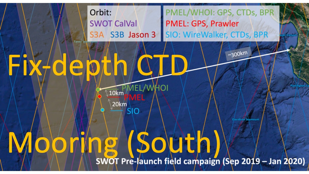
SWOT 2019-2020 Prelaunch Oceanography Field Campaign SIO Moored Fixed-Depth CTDs recent views
This dataset provides the conductivity, temperature and depth (CTD) measurements from the fixed-depth CTD sensors mounted on a full-depth mooring deployed by the SWOT prelaunch... -
SPURS-2 Passive Accoustic Listener (PAL) data from ARGO float deployments during the E. Tropical Pacific field campaign recent views
The SPURS (Salinity Processes in the Upper Ocean Regional Study) project is a NASA-funded oceanographic process study and associated field program that aim to elucidate key... -
GHRSST NOAA/STAR Metop-A AVHRR FRAC ACSPO v2.80 1km L2P Dataset (GDS v2) recent views
The MetOp First Generation (FG) is a European multi-satellite program jointly established by ESA and EUMETSAT, comprising three satellites, MetOp-A, -B and -C. The primary... -
ECCO Gent-McWilliams Ocean Bolus Velocity - Monthly Mean 0.5 Degree (Version 4 Release 4) recent views
This dataset contains monthly-averaged Gent-McWilliams ocean bolus velocity interpolated to a regular 0.5-degree grid from the ECCO Version 4 revision 4 (V4r4) ocean and sea-ice... -
ECCO Sea-Ice Salt Plume Fluxes - Monthly Mean llc90 Grid (Version 4 Release 4) recent views
This dataset provides monthly-averaged sea-ice salt plume fluxes on the native Lat-Lon-Cap 90 (LLC90) model grid from the ECCO Version 4 Release 4 (V4r4) ocean and sea-ice state... -
Aquarius Official Release Level 3 Sea Surface Spiciness Standard Mapped Image Ascending 28-Day Running Mean Data V5.0 recent views
Aquarius Level 3 sea surface salinity spiciness standard mapped image data contains gridded 1 degree spatial resolution spice data averaged over daily, 7 day, monthly, and... -
SWOT Level 2 Lake Single-Pass Vector Data Product, Version 1.1 recent views
Shapefiles of lakes identified in prior lake database and detected features not in the prior river or lake databases. Lake attributes include water surface elevation, area,... -
SWOT Level 2 Water Mask Pixel Cloud Data Product, Version 2.0 recent views
Point cloud of water mask pixels (“pixel cloud”) with geolocated heights, backscatter, geophysical fields, and flags. Point cloud over tile (approx 64x64 km2); half swath (left... -
SWOT Level 1B High-Rate Single-look Complex Data Product, Version 1.1 recent views
High rate data processed to single-look complex SAR images for each antenna. Gridded tile (approx 64x64 km2); half swath (left or right side of full swath). Available in... -
CYGNSS Level 3 Ocean Microplastic Concentration Version 3.2 recent views
The CYGNSS L3 Ocean Microplastic Concentration V3.2 dataset is provided by the CYGNSS Science Team of the University of Michigan. CYGNSS was launched on 15 December 2016, it is... -
OSCAR third degree resolution ocean surface currents - yearly files recent views
OSCAR (Ocean Surface Current Analysis Real-time) contains near-surface ocean current estimates, derived using quasi-linear and steady flow momentum equations. The horizontal... -
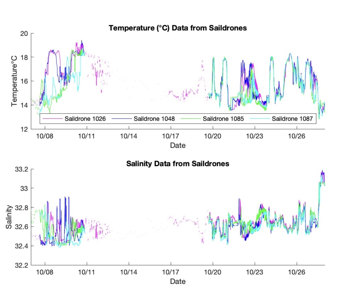
S-MODE L2 Temperature and Salinity from Saildrones Version 1 recent views
This dataset contains Saildrone in-situ measurements taken during the Sub-Mesoscale Ocean Dynamics Experiment (S-MODE) conducted approximately 300 km offshore of San Francisco...

Official websites use .gov
A
.gov website belongs to an official government
organization in the United States.
Secure .gov websites use HTTPS
A
lock (
) or https:// means you’ve safely connected to
the .gov website. Share sensitive information only on official,
secure websites.