
-
Federal
MODIS/Aqua Aerosol Cloud Water Vapor Ozone Monthly L3 Global 1Deg CMG NGDA
National Aeronautics and Space Administration —
The MODIS/Aqua Aerosol Cloud Water Vapor Ozone Monthly L3 Global 1Deg CMG product (MYD08_M3) contains monthly 1 x 1 degree grid average values of atmospheric... -
Federal
MODIS/Aqua Aerosol Cloud Water Vapor Ozone 8-Day L3 Global 1Deg CMG NGDA
National Aeronautics and Space Administration —
The MODIS/Aqua Aerosol Cloud Water Vapor Ozone 8-Day L3 Global 1Deg CMG product (MYD08_E3) contains 8-Day 1 degree x 1 degree grid average values of atmospheric... -
Federal
MODIS/Terra Aerosol Cloud Water Vapor Ozone Daily L3 Global 1Deg CMG NGDA
National Aeronautics and Space Administration —
The MODIS/Terra Aerosol Cloud Water Vapor Ozone Daily L3 Global 1Deg CMG product (MOD08_D3) contains daily 1 x 1 degree grid average values of atmospheric parameters... -
Federal
Global 30-Year Mean Monthly Climatology, 1901-1960 (New et al.)
National Aeronautics and Space Administration —
A data set of 30-year mean monthly surface climate over global land areas, excluding Antarctica. Interpolated from station data to 0.5 degree lat/lon for a range of... -
Federal
GOES-R PLT Geostationary Coastal and Air Pollution Event (GEO-CAPE) Airborne Simulator (GCAS) V1
National Aeronautics and Space Administration —
The GOES-R PLT Geostationary Coastal and Air Pollution Event (GEO-CAPE) Airborne Simulator (GCAS) dataset consist of solar backscattered radiation measured by the... -
Federal
Lightning Imaging Sensor (LIS) on TRMM Backgrounds V4
National Aeronautics and Space Administration —
The Lightning Imaging Sensor (LIS) Backgrounds was collected by the LIS instrument on the Tropical Rainfall Measuring Mission (TRMM) satellite used to detect the... -
Federal
GPM GROUND VALIDATION MISSION REPORTS GCPEX V1
National Aeronautics and Space Administration —
The GPM Ground Validation Mission Reports GCPEx dataset consists of various reports filed by the scientists during the GPM Cold-season Precipitation Experiment... -
Federal
GPM GROUND VALIDATION CAMPAIGN REPORTS IFLOODS V1
National Aeronautics and Space Administration —
The GPM Ground Validation Campaign Reports IFloodS dataset consists of various reports filed by the scientists during the GPM Ground Validation Iowa Flood Studies... -
Federal
HURRICANE AND SEVERE STORM SENTINEL (HS3) GLOBAL HAWK NAVIGATION V1
National Aeronautics and Space Administration —
The Hurricane and Severe Storm Sentinel (HS3) Global Hawk Navigation dataset consists of the real-time navigation and housekeeping data that was acquired from various... -
Federal
Global Monthly Climatology for the Twentieth Century (New et al.)
National Aeronautics and Space Administration —
A 0.5 degree lat/lon data set of monthly surface climate over global land areas, excluding Antarctica. Primary variables are interpolated directly from station time-... -
Federal
LBA-ECO CD-05 Understory Fuel Stick Moisture, km 67 Site, Para, Brazil: 1998-2000
National Aeronautics and Space Administration —
This data set contains moisture content measurements for fuel sticks located in the forest understory of the rainfall exclusion experimental site, Tapajos National... -
Federal
Dynamics and Chemistry of the Summer Stratosphere Radar and Satellite (Remote Sensing) Data Products
National Aeronautics and Space Administration —
DCOTSS-Radar-Satellite-Data feature the radar and satellite data products for the Dynamics and Chemistry of the Summer Stratosphere sub-orbital campaign. Featured in... -
Federal
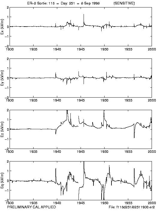
CAMEX-3 LIGHTNING INSTRUMENT PACKAGE (LIP) V1
National Aeronautics and Space Administration —
The CAMEX-3 Lightning Instrument Package (LIP) dataset contains electrical field measurements of lightning within storms studied during the Convection And Moisture... -
Federal
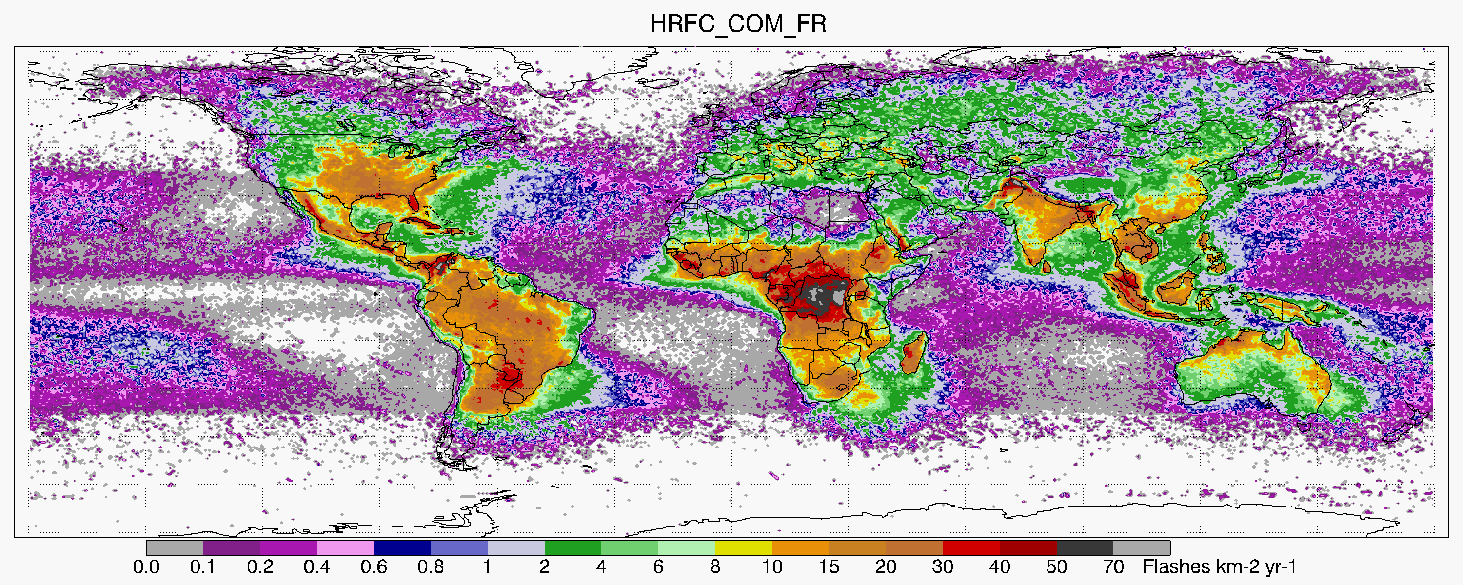
LIS/OTD 0.5 Degree High Resolution Full Climatology (HRFC) V2.3.2015
National Aeronautics and Space Administration —
The LIS/OTD 0.5 Degree High Resolution Full Climatology (HRFC) contains a variety of gridded climatologies of total lightning flash rates obtained from two lightning... -
Federal
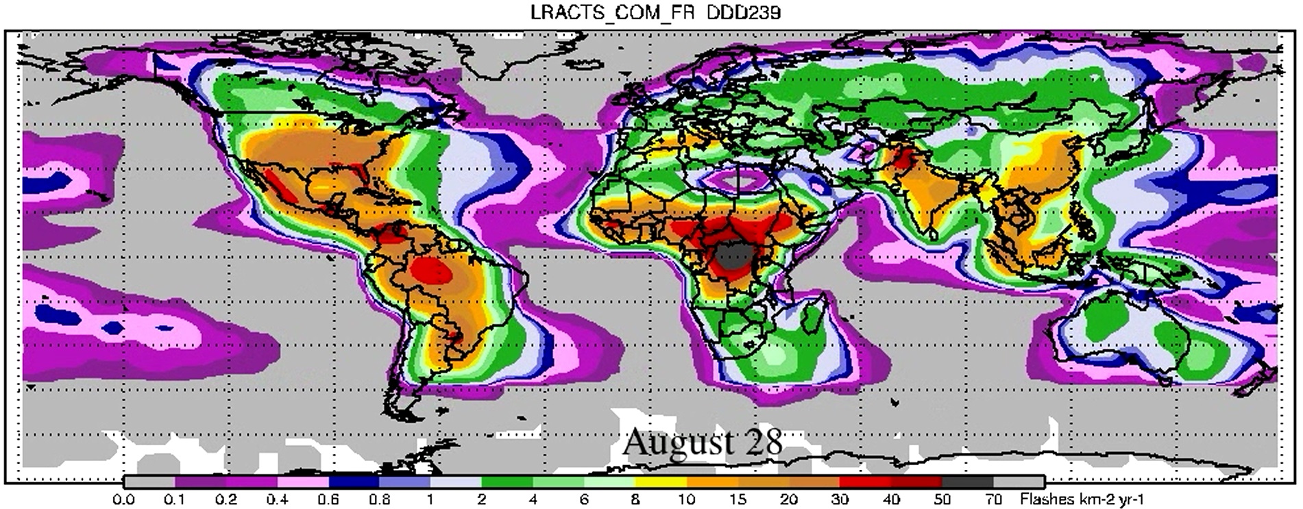
LIS/OTD 2.5 Degree Low Resolution Annual Climatology Time Series (LRACTS) V2.3.2015
National Aeronautics and Space Administration —
The LIS/OTD 2.5 Degree Low Resolution Annual Climatology Time Series (LRACTS) consists of gridded climatologies of total lightning flash rates seen by the spaceborne... -
Federal
HURRICANE AND SEVERE STORM SENTINEL (HS3) WORLD WIDE LIGHTNING LOCATION NETWORK (WWLLN) STORMS V1
National Aeronautics and Space Administration —
The World Wide Lightning Location Network (WWLLN) is a global, ground-based lightning sensor network operated by the University of Washington in Seattle. This network... -
Federal
Dynamics and Chemistry of the Summer Stratosphere Reports
National Aeronautics and Space Administration —
DCOTSS-Reports features important reports and documentation that support the Dynamics and Chemistry of the Summer Stratosphere sub-orbital campaign. Featured in this... -
Federal
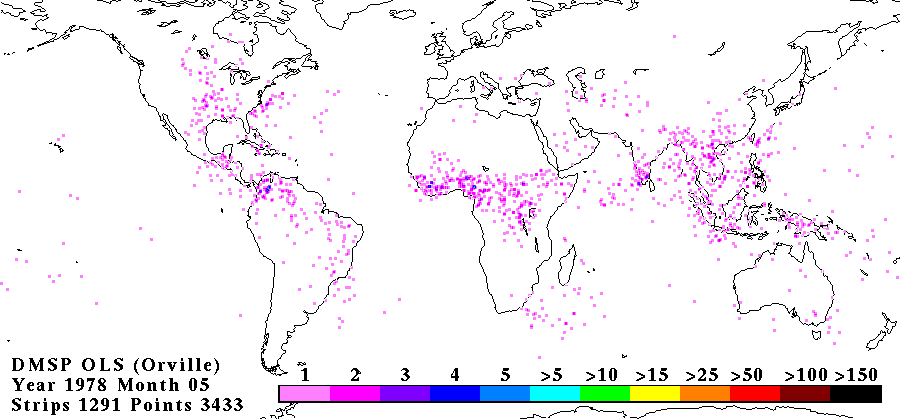
OLS ANALOG DERIVED LIGHTNING V1
National Aeronautics and Space Administration —
The OLS Analog Derived Lightning dataset consists of global lightning signatures from the Defense Meteorological Satellite Program (DMSP) Operational Linescan System... -
Federal
HURRICANE AND SEVERE STORM SENTINEL (HS3) HURRICANE IMAGING RADIOMETER (HIRAD) V1
National Aeronautics and Space Administration —
The Hurricane and Severe Storm Sentinel (HS3) Hurricane Imaging Radiometer (HIRAD) was collected by the Hurricane Imaging Radiometer (HIRAD), which was a multi-band...

Official websites use .gov
A
.gov website belongs to an official government
organization in the United States.
Secure .gov websites use HTTPS
A
lock (
) or https:// means you’ve safely connected to
the .gov website. Share sensitive information only on official,
secure websites.