
-
Federal
MODIS/Terra Calibrated Radiances 5-Min L1B Swath 250m - NRT NGDA
National Aeronautics and Space Administration —
The 250 meter MODIS Level 1B Near Real Time (NRT) data set contains calibrated and geolocated at-aperture radiances for 2 discrete bands located in the 0.62 to 0.88... -
Federal
Landsat 8 Collection 1 Level-2 Scene Products (Surface Reflectance)
Department of the Interior —
The USGS Earth Resources Observation and Science (EROS) Center archive holds data collected by the Landsat suite of satellites, beginning with Landsat 1 in 1972. All... -
Federal
TRMM Microwave Imager Calibrated Radiances L1B 1.5 hours V7 (TRMM_1B11) at GES DISC
National Aeronautics and Space Administration —
This dataset contains TRMM Micrwave Imager (TMI) L1B calibrated radiances in terms of Brightness Temperatures. The TMI calibration algorithm (1B11) converts the... -
Federal
MISR L1B2 Ellipsoid Product subset for the ARCTAS region V003
National Aeronautics and Space Administration —
This file contains Ellipsoid-projected TOA Radiance subset for the ARCTAS region,resampled at the surface and topographically corrected, as well as geometrically... -
Federal
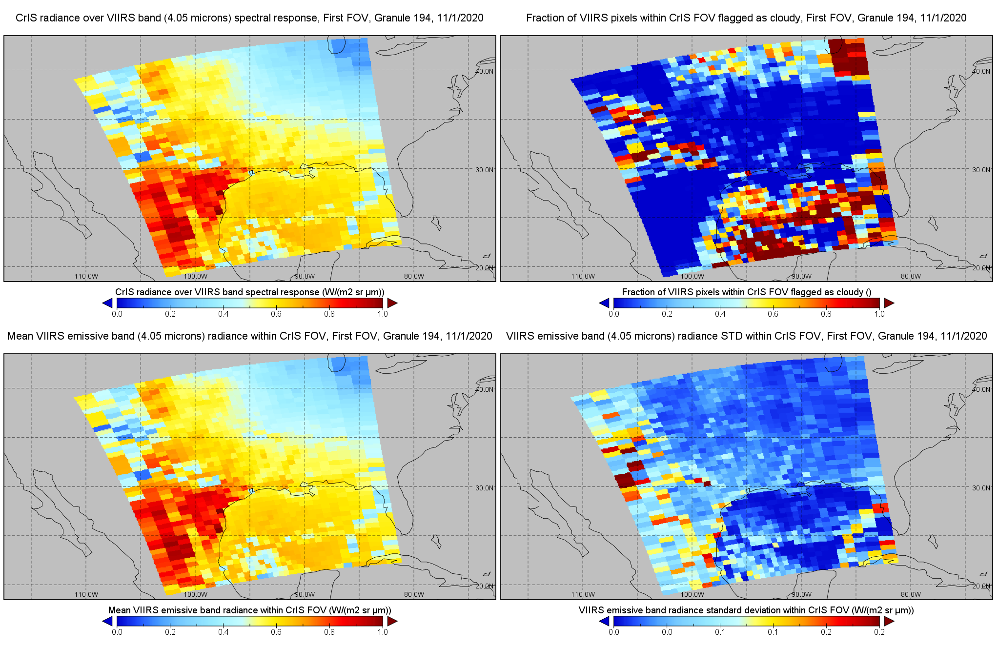
JPSS-1 CrIS IMG: Collocated VIIRS level 1 / cloud mask statistical summary V2 (SNDRJ1CrISL1BIMG) at GES DISC
National Aeronautics and Space Administration —
The Cross-track Infrared Sounder (CrIS) Level 1B Full Spectral Resolution (FSR) data files contain radiance measurements along with ancillary spacecraft, instrument,... -
Federal
MODIS/Aqua Calibrated Radiances 5-Min L1B Swath 250m NGDA
National Aeronautics and Space Administration —
The MODIS/Terra Calibrated Radiances 5-Min L1B Swath 250m data set contains calibrated and geolocated at-aperture radiances for 2 discrete bands located in the 0.62... -
Federal
GPM GROUND VALIDATION ENVIRONMENT CANADA (EC) WEB CAMERA IMAGES GCPEX V1
National Aeronautics and Space Administration —
The GPM Ground Validation Environment Canada (EC) Web Camera Images GCPEx were taken at 5 site locations in Ontario, Canada during the GPM Cold-season Precipitation... -
Federal
MISR Level 1B2 Terrain Product subset for the GoMACCS region V003
National Aeronautics and Space Administration —
Multi-angle Imaging SpectroRadiometer (MISR) is an instrument designed to view Earth with cameras pointed in 9 different directions. As the instrument flies overhead,... -
Federal
CERES Bidirectional Scans JPSS-1 FM6 Edition1-CV
National Aeronautics and Space Administration —
CER_BDS_J01-FM6_Edition1-CV is the Clouds and the Earth's Radiant Energy System (CERES) Bidirectional Scans (BDS) Joint Polar Satellite System 1 (NOAA-20) Flight... -
Federal
IceBridge DMS L3 Ames Stereo Pipeline Orthorectified Images V001
National Aeronautics and Space Administration —
This data set represents a collection of orthorectified images obtained by processing Operation IceBridge DMS stereo images and lidar data using the NASA Ames Stereo... -
Federal
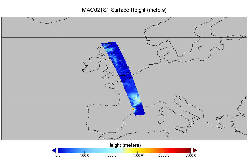
MODIS/Aqua Calibrated Radiances 250m 5-Min L1B Wide Swath Subset along CloudSat V002 (MAC02QS1) at GES DISC NGDA
National Aeronautics and Space Administration —
This is the wide-swath MODIS/Aqua subset along CloudSat field of view track. The goal of the wide-swath subset is to select and return MODIS data that are within... -
Federal
CAMEX-3 MULTISPECTRAL ATMOSPHERIC MAPPING SENSOR (MAMS) V1
National Aeronautics and Space Administration —
The CAMEX-3 Multispectral Atmospheric Mapping Sensor (MAMS) dataset was collected by the Multispectral Atmospheric Mapping Sensor (MAMS), which is a multispectral... -
Federal
CERES Bidirectional Scans Aqua FM3 Edition4
National Aeronautics and Space Administration —
CER_BDS_Aqua-FM3_Edition4 is the Clouds and the Earth's Radiant Energy System (CERES) Bidirectional Scans (BDS) Aqua Flight Model 3 (FM3) Edition 4 data product,... -
Federal
CERES Bidirectional Scans Aqua FM4 Edition4
National Aeronautics and Space Administration —
CER_BDS_Aqua-FM4_Edition4 is the Clouds and the Earth's Radiant Energy System (CERES) Bidirectional Scans (BDS) Aqua Flight Model 4 (FM4) Edition 4 data product,... -
Federal
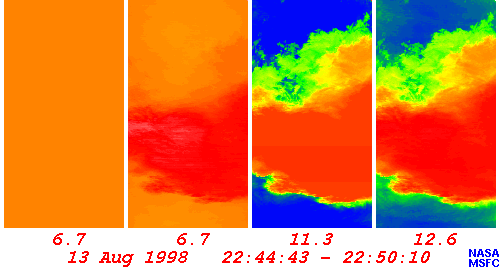
Fourth Convection and Moisture Experiment ER2 MODIS Airborne Simulator
National Aeronautics and Space Administration —
The Convection And Moisture EXperiment (CAMEX) 4 focused on the study of tropical cyclone (hurricane) development, tracking, intensification, and landfalling impacts... -
Federal
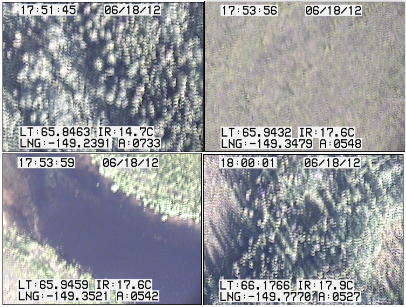
CARVE: In-flight Videos from the CARVE Aircraft, Alaska, 2012-2015
National Aeronautics and Space Administration —
This dataset contains videos captured by a camera mounted on the CARVE aircraft during airborne campaigns over the Alaskan and Canadian Arctic for the Carbon in... -
Federal
VIIRS/NPP Moderate Resolution Bands L1B 6-Min Swath 750 m NRT
National Aeronautics and Space Administration —
The VIIRS/NPP Moderate Resolution Bands L1B 6-Min Swath 750m Near Real Time (NRT) product, short-name VNP02MOD_NRT is among the VIIRS Level 1 and Level 2 swath... -
Federal
First ISCCP Regional Experiment (FIRE) Cirrus Experiment (CI2) NASA ER-2 MODIS Airborne Simulator (MAS) Data
National Aeronautics and Space Administration —
The First ISCCP Regional Experiments have been designed to improve data products and cloud/radiation parameterizations used in general circulation models (GCMs)....

Official websites use .gov
A
.gov website belongs to an official government
organization in the United States.
Secure .gov websites use HTTPS
A
lock (
) or https:// means you’ve safely connected to
the .gov website. Share sensitive information only on official,
secure websites.