
-
Federal
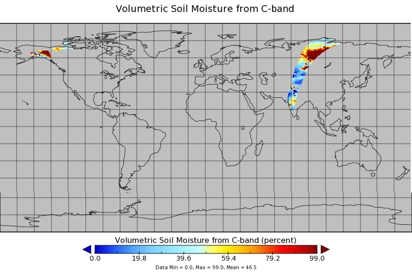
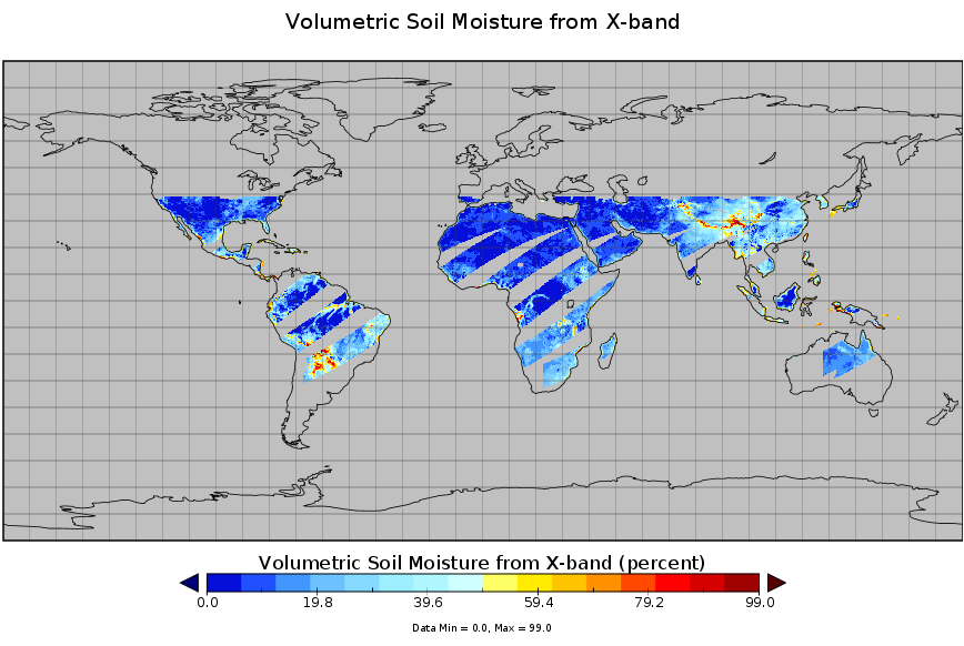
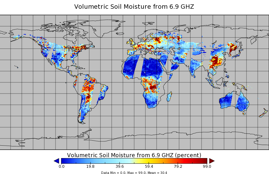
AMSR2/GCOM-W1 surface soil moisture (LPRM) L3 1 day 10 km x 10 km ascending V001 (LPRM_AMSR2_DS_A_SOILM3) at GES DISC
National Aeronautics and Space Administration —
AMSR2/GCOM-W1 surface soil moisture (LPRM) L3 1 day 10 km x 10 km ascending V001 is a Level 3 (gridded) data set. Its land surface parameters, surface soil moisture,... -
Federal
CLPX-Model: Land Data Assimilation System (LDAS) Data, Version 1
National Aeronautics and Space Administration —
The LDAS data set contains 43 model and observation-based fields produced by the LDAS uncoupled modeling system at the NASA Goddard Space Flight Center using the... -
Federal
Combined ASTER and MODIS Emissivity database over Land (CAMEL) Emissivity Monthly Global 0.05Deg V003 NGDA
National Aeronautics and Space Administration —
The NASA Making Earth System Data Records for Use in Research Environments (MEaSUREs) (https://earthdata.nasa.gov/community/community-data-system-programs/measures-... -
Federal
WindSat/Coriolis surface soil moisture (LPRM) L2 V001 (LPRM_WINDSAT_SOILM2) at GES DISC
National Aeronautics and Space Administration —
WindSat/Coriolis surface soil moisture (LPRM) L2 V001 is a Level 2 (swath) data set. Its land surface parameters, surface soil moisture, land surface (skin)... -
Federal
NLDAS VIC Land Surface Model L4 Monthly Climatology 0.125 x 0.125 degree V2.0 (NLDAS_VIC0125_MC) at GES DISC
National Aeronautics and Space Administration —
This data set contains a series of land surface parameters simulated from the VIC land-surface model (LSM) for Phase 2 of the North American Land Data Assimilation... -
Federal
BOREAS/SRC AMS Suite A Surface Meteorological and Radiation Data: 1996
National Aeronautics and Space Administration —
Contains the data collected in 1996 by the AMS suite A instrument set operated by SRC and provided to BORIS. -
Federal
NLDAS Mosaic Land Surface Model L4 Hourly 0.125 x 0.125 degree V002 (NLDAS_MOS0125_H) at GES DISC
National Aeronautics and Space Administration —
This data set contains a series of land surface parameters simulated from the Mosaic land-surface model (LSM) for Phase 2 of the North American Land Data Assimilation... -
Federal
TMI/TRMM surface soil moisture (LPRM) L3 1 day 25 km x 25 km daytime V001 (LPRM_TMI_DY_SOILM3) at GES DISC
National Aeronautics and Space Administration —
TMI/TRMM surface soil moisture (LPRM) L3 1 day 25 km x 25 km daytime V001 is a Level 3 (gridded) data set. Its land surface parameters, surface soil moisture, land... -
Federal
ASTER Global Emissivity Dataset, 100 meter, HDF5 V003 NGDA
National Aeronautics and Space Administration —
Advanced Spaceborne Thermal Emission and Reflection Radiometer (ASTER) Global Emissivity Dataset (GED) land surface temperature and emissivity (LST&E) data... -
Federal
CLPX-Satellite: MODIS Radiances, Reflectances, Snow Cover and Related Grids, Version 1 NGDA
National Aeronautics and Space Administration —
This data set provides Moderate Resolution Imaging Spectroradiometer (MODIS) data as part of the Cold Land Processes Field Experiment (CLPX). Parameters include... -
Federal
Combined ASTER and MODIS Emissivity database over Land (CAMEL) Coefficient Monthly Global 0.05Deg V003 NGDA
National Aeronautics and Space Administration —
The NASA Making Earth System Data Records for Use in Research Environments (MEaSUREs) (https://earthdata.nasa.gov/community/community-data-system-programs/measures-... -
Federal
BOREAS/SRC AMS Suite A Surface Meteorological and Radiation Data: 1994
National Aeronautics and Space Administration —
Contains the data collected in 1994 by the AMS suite A instrument set operated by SRC and provided to BORIS. -
Federal
TMI/TRMM surface soil moisture (LPRM) L2 V001 (LPRM_TMI_SOILM2) at GES DISC
National Aeronautics and Space Administration —
TMI/TRMM surface soil moisture (LPRM) L2 V001 is a Level 2 (swath) data set. Its land surface parameters, surface soil moisture, land surface (skin) temperature, and... -
Federal
NLDAS Mosaic Land Surface Model L4 Hourly 0.125 x 0.125 degree V2.0 (NLDAS_MOS0125_H) at GES DISC
National Aeronautics and Space Administration —
This data set contains thirty-eight fields simulated from the Mosaic land-surface model (LSM) for Phase 2 of the North American Land Data Assimilation System... -
Federal
NCA-LDAS Noah-3.3 Land Surface Model L4 Daily 0.125 x 0.125 degree V2.0 (NCALDAS_NOAH0125_D) at GES DISC
National Aeronautics and Space Administration —
The National Climate Assessment - Land Data Assimilation System, or NCA-LDAS, is a terrestrial water reanalysis in support of the United States Global Change Research... -
Federal
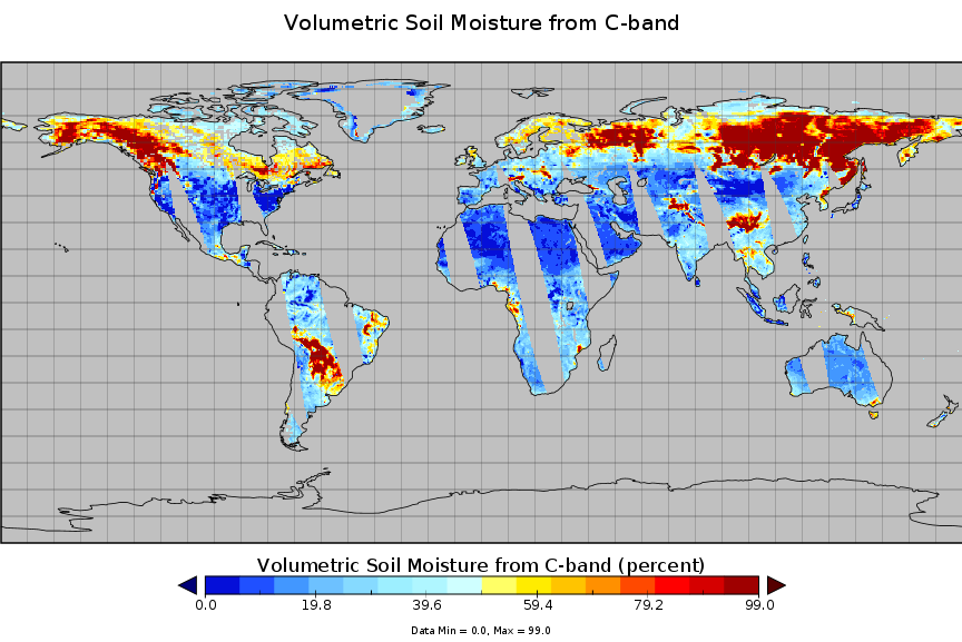
AMSR2/GCOM-W1 surface soil moisture (LPRM) L3 1 day 10 km x 10 km descending V001 (LPRM_AMSR2_DS_D_SOILM3) at GES DISC
National Aeronautics and Space Administration —
AMSR2/GCOM-W1 surface soil moisture (LPRM) L3 1 day 10 km x 10 km descending V001 is a Level 3 (gridded) data set. Its land surface parameters, surface soil moisture,... -
Federal
BOREAS AFM-01 NOAA/ATDD Long-EZ Aircraft Flux Data over the SSA
National Aeronautics and Space Administration —
Data include aircraft altitude, wind direction, wind speed, air temperature, potential temperature, water mixing ratio, U and V components of wind velocity, static... -
Federal
AMSR-E/Aqua surface soil moisture (LPRM) L3 1 day 25 km x 25 km ascending V002 (LPRM_AMSRE_A_SOILM3) at GES DISC
National Aeronautics and Space Administration —
AMSR-E/Aqua surface soil moisture (LPRM) L3 1 day 25 km x 25 km ascending V002 is a Level 3 (gridded) data set. Its land surface parameters, surface soil moisture,... -
Federal
BOREAS TE-21 Daily Surface Meteorological Data
National Aeronautics and Space Administration —
Contains meteorological measurement data collected by TE-21. -
Federal
BOREAS TE-11 Surface Meteorological Data
National Aeronautics and Space Administration —
Data collected in support of efforts to characterize and interpret information on the sapflow, gas exchange, and lichen photosynthesis.

Official websites use .gov
A
.gov website belongs to an official government
organization in the United States.
Secure .gov websites use HTTPS
A
lock (
) or https:// means you’ve safely connected to
the .gov website. Share sensitive information only on official,
secure websites.