
-
Federal
MERRA-2 tavg1_2d_flx_Nx: 2d,1-Hourly,Time-Averaged,Single-Level,Assimilation,Surface Flux Diagnostics 0.625 x 0.5 degree V5.12.4 (M2T1NXFLX) at GES DISC
National Aeronautics and Space Administration —
M2T1NXFLX (or tavg1_2d_flx_Nx) is an hourly time-averaged 2-dimensional data collection in Modern-Era Retrospective analysis for Research and Applications version 2... -
Federal
Global Forest Ecosystem Structure and Function Data For Carbon Balance Research
National Aeronautics and Space Administration —
A comprehensive global database has been assembled to quantify CO2 fluxes and pathways across different levels of integration (from photosynthesis up to net ecosystem... -
Federal
Burned and Unburned Field Site Data, Noatak, Seward, and North Slope, AK, 2016-2018
National Aeronautics and Space Administration —
This dataset includes field measurements from unburned and burned 10 m x 10 m and 1 m x 1 m plots in the Noatak, Seward, and North Slope regions of the Alaskan tundra... -
Federal
ABoVE: Synthesis of Burned and Unburned Forest Site Data, AK and Canada, 1983-2016
National Aeronautics and Space Administration —
This dataset is a synthesis of field plot characterization data, derived above-ground and below-ground combusted carbon, and acquired Fire Weather Index (FWI) System... -
Federal
Land Surface Atmospheric Boundary Interaction Product L3 V1(LANDMET) at GES DISC
National Aeronautics and Space Administration —
This product is a multi-variate data compilation that reconciles the variation scales of these multiple measurements from varies resources, merges and maps them into... -
Federal
ISLSCP II Climate Research Unit CRU05 Monthly Climate Data
National Aeronautics and Space Administration —
This data set contains a mean monthly climatology for several climate variables averaged over the period from 1961 to 1990, and constructed from a data set of station... -
Federal
Circumpolar Arctic Vegetation, Geobotanical, Physiographic Maps, 1982-2003
National Aeronautics and Space Administration —
This data set provides the spatial distributions of vegetation types, geobotanical characteristics, and physiographic features for the circumpolar Arctic tundra biome... -
Federal
NPP Multi-Biome: Summary Data from Intensive Studies at 125 Sites, 1936-2006
National Aeronautics and Space Administration —
This data set, NPP Multi-Biome: Summary Data from Intensive Studies at 125 Sites, 1936-2006, contains a single shapefile that provides site-level summary statistics... -
Federal
ISLSCP II CRU05 Climate Time Series for Global Land Areas, 1986-1995
National Aeronautics and Space Administration —
This data set contains monthly climate time series data created by the Climatic Research Unit (CRU) at the University of East Anglia, U.K.,for every year covering the... -
Federal
ISLSCP II Reanalysis Near-Surface Meteorology Data
National Aeronautics and Space Administration —
This data set for the ISLSCP Initiative II data collection provides near surface meteorological variables, fluxes of heat, moisture and momentum at the surface, and... -
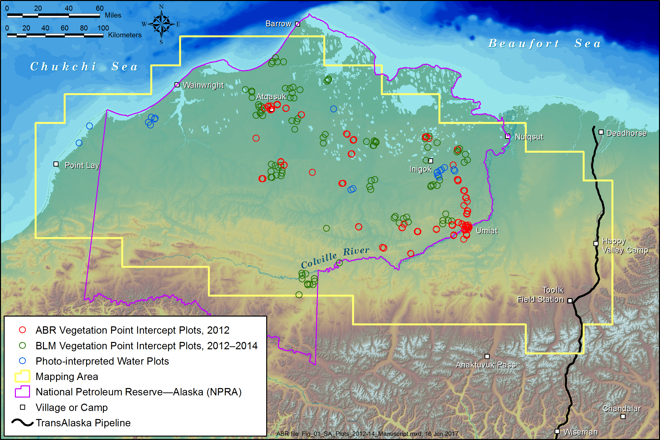
Federal
ABoVE: Tundra Plant Functional Type Continuous-Cover, North Slope, Alaska, 2010-2015
National Aeronautics and Space Administration —
This dataset provides predicted continuous-field cover for tundra plant functional types (PFTs), across ~125,000 km2 of Alaska's North Slope at 30-m resolution. The... -
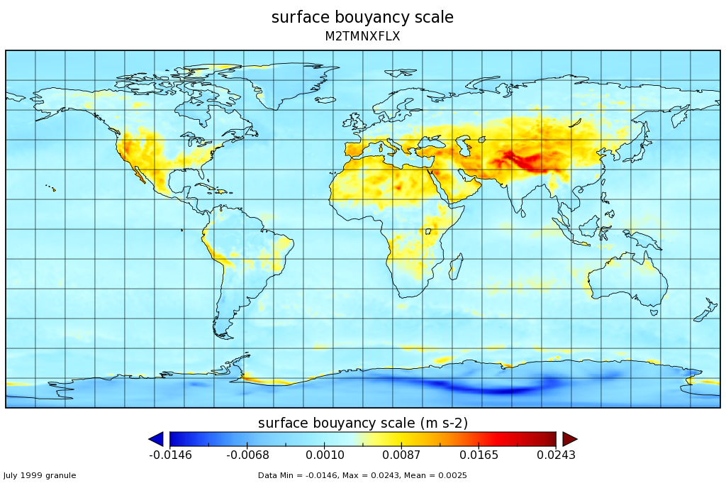
Federal
MERRA-2 tavgM_2d_flx_Nx: 2d,Monthly mean,Time-Averaged,Single-Level,Assimilation,Surface Flux Diagnostics 0.625 x 0.5 degree V5.12.4 (M2TMNXFLX) at GES DISC
National Aeronautics and Space Administration —
M2TMNXFLX (or tavgM_2d_flx_Nx) is a time-averaged 2-dimensional monthly mean data collection in Modern-Era Retrospective analysis for Research and Applications... -
Federal
Vegetation Drought Response Index (VegDRI)
National Aeronautics and Space Administration —
The National Drought Mitigation Center produces VegDRI in collaboration with the US Geological Survey's (USGS) Center for Earth Resources Observation and Science... -
Federal
Physical Oceanography Distributed Active Archive Center (PO.DAAC)
National Aeronautics and Space Administration —
PO.DAAC is an element of the Earth Observing System Data Information System (EOSDIS). PO.DAAC's primary responsibility is to provide distribution and archive support... -
Federal
GLAS/ICESat L1B Global Backscatter Data (HDF5) V033
National Aeronautics and Space Administration —
GLAH07 Level-1B global backscatter data are provided at full instrument resolution. The product includes full 532 nm (41.1 to -1.0 km) and 1064 nm (20 to -1 km)... -
Federal
POLARIS Photolysis Frequencies (J-Values)
National Aeronautics and Space Administration —
POLARIS_jValue_AircraftInSitu_ER2_Data is the photolysis frequencies (j-values) collected during the Photochemistry of Ozone Loss in the Arctic Region in Summer...

Official websites use .gov
A
.gov website belongs to an official government
organization in the United States.
Secure .gov websites use HTTPS
A
lock (
) or https:// means you’ve safely connected to
the .gov website. Share sensitive information only on official,
secure websites.