
-
Federal
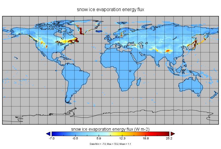
CLPX-Model: Land Data Assimilation System (LDAS) Data, Version 1
National Aeronautics and Space Administration —
The LDAS data set contains 43 model and observation-based fields produced by the LDAS uncoupled modeling system at the NASA Goddard Space Flight Center using the... -
Federal
Combined ASTER and MODIS Emissivity database over Land (CAMEL) Emissivity Monthly Global 0.05Deg V003 NGDA
National Aeronautics and Space Administration —
The NASA Making Earth System Data Records for Use in Research Environments (MEaSUREs) (https://earthdata.nasa.gov/community/community-data-system-programs/measures-... -
Federal
NLDAS VIC Land Surface Model L4 Monthly Climatology 0.125 x 0.125 degree V2.0 (NLDAS_VIC0125_MC) at GES DISC
National Aeronautics and Space Administration —
This data set contains a series of land surface parameters simulated from the VIC land-surface model (LSM) for Phase 2 of the North American Land Data Assimilation... -
Federal
CLPX-Ground: ISA Snow Depth Transects and Related Measurements, Version 2
National Aeronautics and Space Administration —
This data set consists of snow depth data from nine study areas, within three larger-scale areas in northern Colorado (Fraser, North Park, and Rabbit Ears Meso-cell... -
Federal
BOREAS/SRC AMS Suite A Surface Meteorological and Radiation Data: 1996
National Aeronautics and Space Administration —
Contains the data collected in 1996 by the AMS suite A instrument set operated by SRC and provided to BORIS. -
Federal
Seasonal frost penetration, Sleepers River Research Watershed, Vermont, USA, Version 1
National Aeronautics and Space Administration —
The frost tube network is located within a 3.25-square-mile sub-watershed of the Sleepers River Research Watershed near Danville, Vermont, USA. Tubes were positioned... -
Federal
Upper soil temperatures in the Kolyma Highland, Version 1
National Aeronautics and Space Administration —
This data set contains soil temperature and meteorological data for various sampling locations near the Aborigen research station in the Kolyma Highland, Northeastern... -
Federal
Arctic Vegetation Plots, Prudhoe Bay ArcSEES Road Study, Lake Colleen, Alaska, 2014
National Aeronautics and Space Administration —
This dataset provides environmental, soil, and vegetation data collected from study plots in the vicinity of Lake Colleen off the Spine Road at Prudhoe Bay, Alaska,... -
Federal
NLDAS Mosaic Land Surface Model L4 Hourly 0.125 x 0.125 degree V002 (NLDAS_MOS0125_H) at GES DISC
National Aeronautics and Space Administration —
This data set contains a series of land surface parameters simulated from the Mosaic land-surface model (LSM) for Phase 2 of the North American Land Data Assimilation... -
Federal
MERRA-2 tavgM_2d_lnd_Nx: 2d,Monthly mean,Time-Averaged,Single-Level,Assimilation,Land Surface Diagnostics 0.625 x 0.5 degree V5.12.4 (M2TMNXLND) at GES DISC
National Aeronautics and Space Administration —
M2TMNXLND (or tavgM_2d_lnd_Nx) is a time-averaged 2-dimensional monthly mean data collection in Modern-Era Retrospective analysis for Research and Applications... -
Federal
ABoVE: Wolf Denning Phenology and Reproductive Success, Alaska and Canada, 2000-2017 NGDA
National Aeronautics and Space Administration —
This dataset provides annual gray wolf (Canis lupus) denning spatial information and timing, associated climatic and phenologic metrics, and reproductive success... -
Federal
MERRA-2 tavgU_2d_lnd_Nx: 2d,diurnal,Time-Averaged,Single-Level,Assimilation,Land Surface Diagnostics 0.625 x 0.5 degree V5.12.4 (M2TUNXLND) at GES DISC
National Aeronautics and Space Administration —
M2TUNXLND (or tavgU_2d_lnd_Nx) is a time-averaged 2-dimensional monthly diurnal means data collection in Modern-Era Retrospective analysis for Research and... -
Federal
CLPX-Satellite: MODIS Radiances, Reflectances, Snow Cover and Related Grids, Version 1 NGDA
National Aeronautics and Space Administration —
This data set provides Moderate Resolution Imaging Spectroradiometer (MODIS) data as part of the Cold Land Processes Field Experiment (CLPX). Parameters include... -
Federal
Combined ASTER and MODIS Emissivity database over Land (CAMEL) Coefficient Monthly Global 0.05Deg V003 NGDA
National Aeronautics and Space Administration —
The NASA Making Earth System Data Records for Use in Research Environments (MEaSUREs) (https://earthdata.nasa.gov/community/community-data-system-programs/measures-... -
Federal
BOREAS/SRC AMS Suite A Surface Meteorological and Radiation Data: 1994
National Aeronautics and Space Administration —
Contains the data collected in 1994 by the AMS suite A instrument set operated by SRC and provided to BORIS. -
Federal
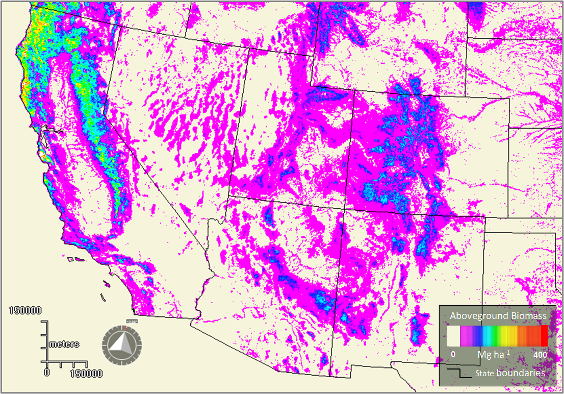
Forest Aboveground Biomass for the Southwestern U.S. from MISR, 2000-2021
National Aeronautics and Space Administration —
This dataset provides estimates of forest aboveground biomass (AGB; in Mg ha-1) at a resolution of 250 m for the southwestern United States over the time period... -
Federal
Combined ASTER and MODIS Emissivity database over Land (CAMEL) Uncertainty Monthly Global 0.05Deg V001 NGDA
National Aeronautics and Space Administration —
The NASA Making Earth System Data Records for Use in Research Environments (MEaSUREs) (https://earthdata.nasa.gov/community/community-data-system-programs/measures-... -
Federal
Combined ASTER and MODIS Emissivity database over Land (CAMEL) Emissivity Monthly Global 0.05Deg V001 NGDA
National Aeronautics and Space Administration —
The NASA Making Earth System Data Records for Use in Research Environments (MEaSUREs) (https://earthdata.nasa.gov/community/community-data-system-programs/measures-... -
Federal
Borehole and environmental protection descriptive and numerical data, Yamal Peninsula, Russia, Version 1
National Aeronautics and Space Administration —
This database of selected borehole records from the Yamal Peninsula, Russia, contains environmental descriptions (textual and numerical) of the units on the index... -
Federal
Arctic Vegetation Plots in Willow Communities, North Slope, Alaska, 1997
National Aeronautics and Space Administration —
This data set provides environmental, soil, and vegetation data collected in July and August 1997 from 85 study plots in willow shrub communities located along a...

Official websites use .gov
A
.gov website belongs to an official government
organization in the United States.
Secure .gov websites use HTTPS
A
lock (
) or https:// means you’ve safely connected to
the .gov website. Share sensitive information only on official,
secure websites.