
-
Federal
H02761: NOS Hydrographic Survey
National Oceanic and Atmospheric Administration, Department of Commerce —
The National Oceanic and Atmospheric Administration (NOAA) has the statutory mandate to collect hydrographic data in support of nautical chart compilation for safe... -
State
Updated tsunami inundation maps for Seward and northern Resurrection Bay, Alaska
State of Alaska —
Updated tsunami inundation maps for Seward and northern Resurrection Bay, Alaska, Report of Investigation 2022-3, updates the previous tsunami hazard assessment for... -
Federal
H02853: NOS Hydrographic Survey
National Oceanic and Atmospheric Administration, Department of Commerce —
The National Oceanic and Atmospheric Administration (NOAA) has the statutory mandate to collect hydrographic data in support of nautical chart compilation for safe... -
Federal
Shoreline Mapping Program of Resurrection Bay, AK, AK01B NGDA
National Oceanic and Atmospheric Administration, Department of Commerce —
These data were automated to provide an accurate high-resolution composite shoreline of Resurrection Bay, AK suitable as a geographic information system (GIS) data... -
Federal
National Status and Trends: Mussel Watch Program - Resurrection Bay Database
National Oceanic and Atmospheric Administration, Department of Commerce —
In response to the growing concerns among Native communities about the safety of subsistence shellfish, this project assessed the health risks associated with... -
State
Photogrammetry-derived digital surface model and orthoimagery of land areas near Resurrection Bay, Alaska
State of Alaska —
The State of Alaska Division of Geological & Geophysical Surveys (DGGS) produced a digital surface model (DSM) and an orthorectified aerial optical image mosaic... -
Federal
Low resolution STD/CTD and other data from ACONA in coastal waters of Alaska from 1979-03-17 to 1979-05-10 (NCEI Accession 8000131)
National Oceanic and Atmospheric Administration, Department of Commerce —
Data has been processed by NODC to the NODC standard High-Resolution CTD/STD (F022) format. The F022 format contains high-resolution data collected using CTD... -
Federal
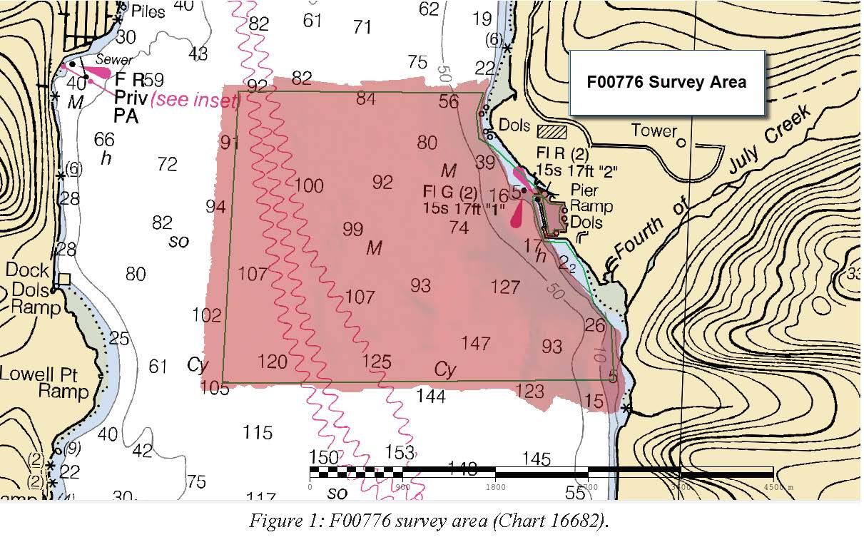
F00776: NOS Hydrographic Survey , 2019-06-05
National Oceanic and Atmospheric Administration, Department of Commerce —
The National Oceanic and Atmospheric Administration (NOAA) has the statutory mandate to collect hydrographic data in support of nautical chart compilation for safe... -
State
Photogrammetry-derived digital surface model and orthoimagery of land areas near Resurrection Bay, Alaska
State of Alaska —
The State of Alaska Division of Geological & Geophysical Surveys (DGGS) produced a digital surface model (DSM) and an orthorectified aerial optical image mosaic... -
State
Tsunami inundation maps of Seward and northern Resurrection Bay, Alaska
State of Alaska —
The purpose of this study is to evaluate tsunami hazard for the community of Seward and northern Resurrection Bay area, Alaska. This report will provide guidance to... -
Federal
F00683: NOS Hydrographic Survey , 2016-08-26
National Oceanic and Atmospheric Administration, Department of Commerce —
The National Oceanic and Atmospheric Administration (NOAA) has the statutory mandate to collect hydrographic data in support of nautical chart compilation for safe... -
Federal
Seward, Alaska 8 arc-second MHW Coastal Digital Elevation Model
National Oceanic and Atmospheric Administration, Department of Commerce —
The 8-second Seward, Alaska Elevation Grid provides bathymetric data of 8-second resolution in geographic coordinates. This grid is strictly for tsunami inundation... -
Federal
Seward, Alaska 3 arc-second MHW Coastal Digital Elevation Model
National Oceanic and Atmospheric Administration, Department of Commerce —
The 3 arc-second Seward Alaska Elevation Grid provides bathymetric data of 2.67-second resolution in geographic coordinates. This grid is strictly for tsunami... -
Federal
Seward, Alaska 1/3 arc-second MHW Coastal Digital Elevation Model
National Oceanic and Atmospheric Administration, Department of Commerce —
The 1/3-second Seward Alaska Elevation Grid provides bathymetric data of 1/3-second resolution in geographic coordinates. This grid is strictly for tsunami inundation... -
Federal
Seward, Alaska Tsunami Forecast Grids for MOST Model
National Oceanic and Atmospheric Administration, Department of Commerce —
The Seward, Alaska Forecast Model Grids provides bathymetric data strictly for tsunami inundation modeling with the Method of Splitting Tsunami (MOST) model. MOST is... -
Federal
Seward, Alaska 1 arc-second MHW Coastal Digital Elevation Model
National Oceanic and Atmospheric Administration, Department of Commerce —
The 1 arc-second Seward Alaska Elevation Grid provides bathymetric data of .89-second resolution in geographic coordinates. This grid is strictly for tsunami... -
Federal
Archival and Discovery of May 22, 1960 Tsunami Event on Marigrams
National Oceanic and Atmospheric Administration, Department of Commerce —
NOAA National Centers for Environmental Information have more than 3,000 tsunami marigram (tide gauge) records in both image and paper format. The majority of these...

Official websites use .gov
A
.gov website belongs to an official government
organization in the United States.
Secure .gov websites use HTTPS
A
lock (
) or https:// means you’ve safely connected to
the .gov website. Share sensitive information only on official,
secure websites.