
-
Federal
SLSTR/Sentinel-3B L1 Full Resolution Top of Atmosphere Radiances and Brightness Temperature
National Aeronautics and Space Administration —
The SLSTR/Sentinel-3B L1 Full Resolution Top of Atmosphere Radiances and Brightness Temperature product with shortname S3B_SL_1_RBT, is generated from the data... -
Federal
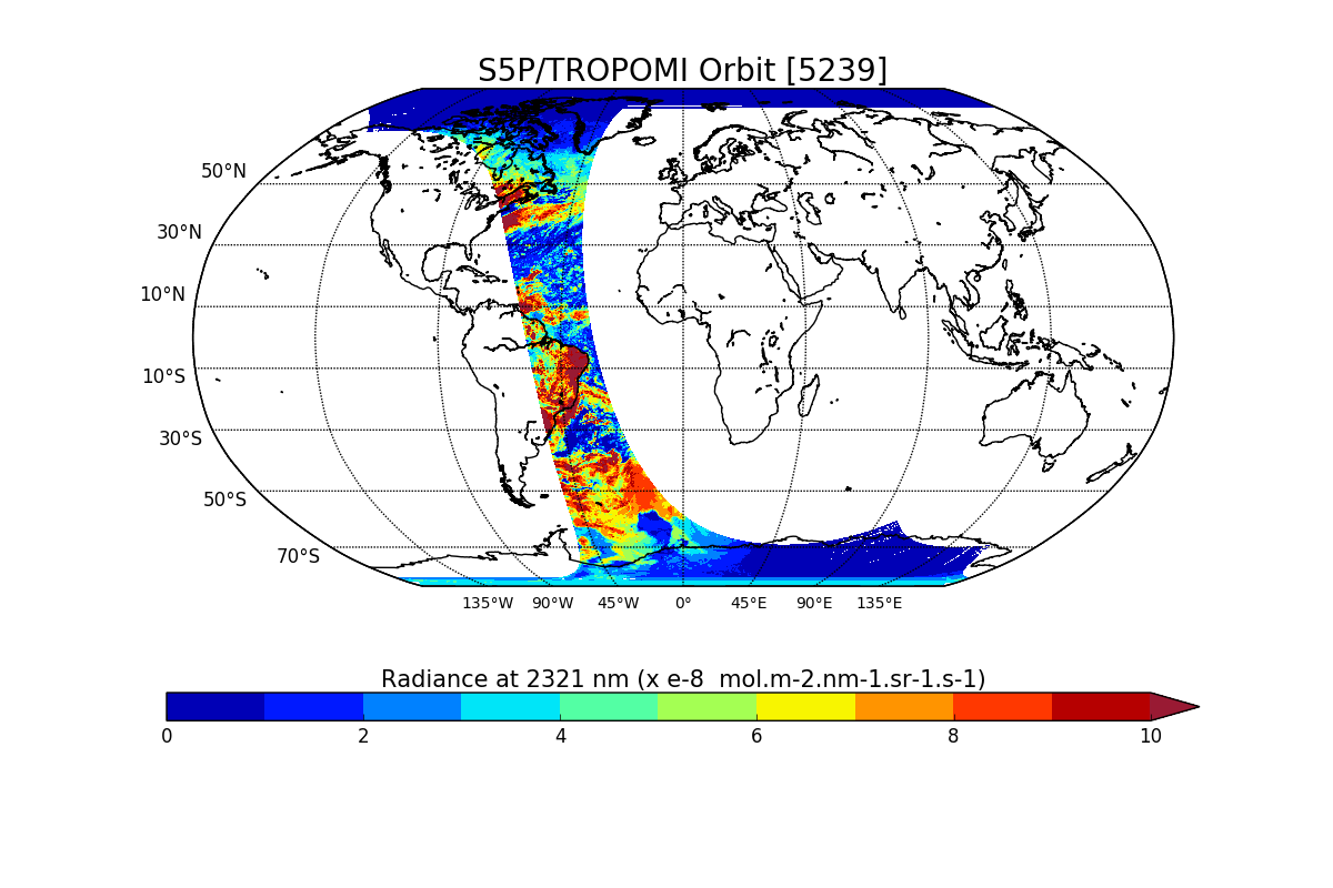
Sentinel-5P TROPOMI Radiance product band 7 (SWIR detector) L1B V1 (S5P_L1B_RA_BD7) at GES DISC
National Aeronautics and Space Administration —
Starting from August 6th in 2019, Sentinel-5P TROPOMI along-track high spatial resolution (~5.5km at nadir) has been implemented. For data after August 6th of 2019,... -
Federal
SMAP_L1B_SIGMA_NAUGHT_LOW_RES_QA_V002
National Aeronautics and Space Administration —
SMAP Level 1B Sigma Naught Low Res Data Quality Info Version 2 -
Federal
SMAP_L1A_RADAR_RECEIVE_ONLY_QA_V003
National Aeronautics and Space Administration —
SMAP Level 1A Radar Receive Only Data Quality Information Version 3 -
Federal
TRMM Microwave Imager Calibrated Radiances L1B 1.5 hours V7 (TRMM_1B11) at GES DISC
National Aeronautics and Space Administration —
This dataset contains TRMM Micrwave Imager (TMI) L1B calibrated radiances in terms of Brightness Temperatures. The TMI calibration algorithm (1B11) converts the... -
Federal
Sentinel-5P TROPOMI Radiance product band 1 (UV detector) L1B 5.5km x 21km V1 (S5P_L1B_RA_BD1_HiR) at GES DISC
National Aeronautics and Space Administration —
Starting from August 6th in 2019, Sentinel-5P TROPOMI along-track high spatial resolution (~5.5km at nadir) has been implemented. For data before August 6th of 2019,... -
Federal
SMAP_L1A_RADAR_METADATA_V001
National Aeronautics and Space Administration —
SMAP Level 1A Radar Product Metadata -
Federal
Sentinel-5P TROPOMI Radiance product band 4 (UVIS detector) L1B V1 (S5P_L1B_RA_BD4) at GES DISC
National Aeronautics and Space Administration —
Starting from August 6th in 2019, Sentinel-5P TROPOMI along-track high spatial resolution (~5.5km at nadir) has been implemented. For data after August 6th of 2019,... -
Federal
GPM GROUND VALIDATION CITATION VIDEOS IPHEX V1
National Aeronautics and Space Administration —
The GPM Ground Validation Citation Videos IPHEx dataset was collected during the Global Precipitation Measurement (GPM) mission Integrated Precipitation and Hydrology... -
Federal
First ISCCP Regional Experiment (FIRE) Cirrus 1 Colorado State University Sabreliner Aircraft Radiometric and Meteorological Data
National Aeronautics and Space Administration —
This data set contains meteorological and radiometeric data from the NCAR Sabreliner aircraft that was collected during the 1986 FIRE Cirrus IFO. The NCAR Sabreliner... -
Federal
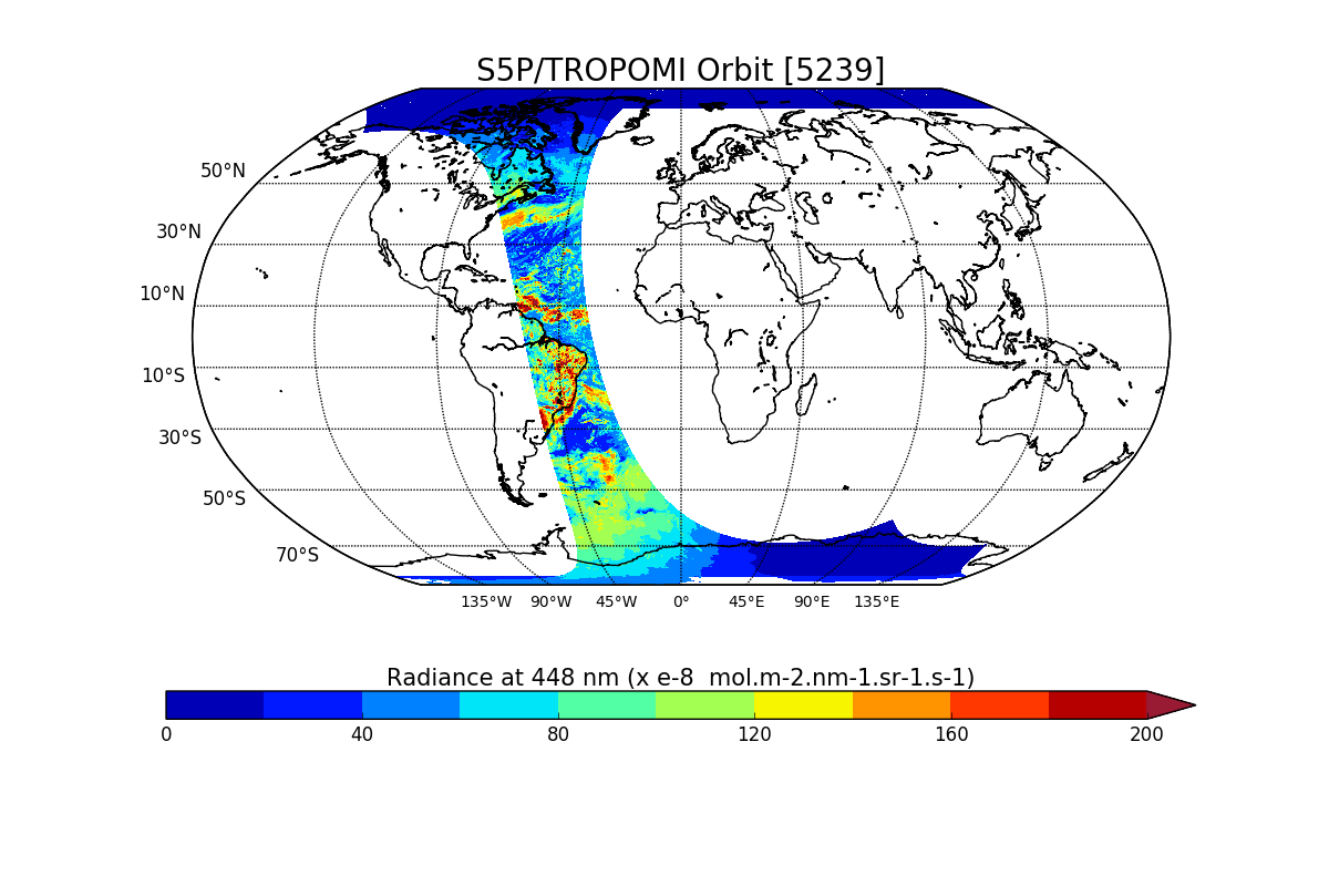
Sentinel-5P TROPOMI Radiance product band 2 (UV detector) L1B V1 (S5P_L1B_RA_BD2) at GES DISC
National Aeronautics and Space Administration —
Starting from August 6th in 2019, Sentinel-5P TROPOMI along-track high spatial resolution (~5.5km at nadir) has been implemented. For data after August 6th of 2019,... -
Federal
Sentinel-5P TROPOMI Radiance product band 5 (NIR detector) L1B 5.5km x 3.5km V2 (S5P_L1B_RA_BD5_HiR) at GES DISC
National Aeronautics and Space Administration —
Starting from August 6th in 2019, Sentinel-5P TROPOMI along-track high spatial resolution (~5.5km at nadir) has been implemented. For data before August 6th of 2019,... -
Federal
Sentinel-5P TROPOMI Radiance product band 8 (SWIR detector) L1B 5.5km x 7km V2 (S5P_L1B_RA_BD8_HiR) at GES DISC
National Aeronautics and Space Administration —
Starting from August 6th in 2019, Sentinel-5P TROPOMI along-track high spatial resolution (~5.5km at nadir) has been implemented. For data before August 6th of 2019,... -
Federal
ATom: Flight Dynamics and Environmental Parameters of the NASA DC-8 Aircraft
National Aeronautics and Space Administration —
This dataset contains flight dynamics and environmental parameters (often referred to as housekeeping) specific to the DC-8 aircraft as collected from an assortment... -
Federal
GPM Ground Validation Campaign Reports OLYMPEX V1
National Aeronautics and Space Administration —
The GPM Ground Validation Campaign Reports OLYMPEX dataset consists of flight reports, weather forecasts, instrument reports, scientist summaries, and plan-of-day... -
Federal
Files containing only extrapolated orbital metadata, to be read via SDP Toolkit, Binary Format NGDA
National Aeronautics and Space Administration —
AM1EPHNE is the Terra Near Real Time (NRT) 2-hour spacecraft Extrapolated ephemeris data file in native format. The file name format is the following:... -
Federal
GRIP HURRICANE IMAGING RADIOMETER (HIRAD) V1
National Aeronautics and Space Administration —
The GRIP Hurricane Imaging Radiometer (HIRAD) V1 dataset contains measurements of brightness temperature taken at 4, 5, 6 and 6.6 GHz, as well as MERRA 2 m wind speed... -
Federal
SMAP_L1C_SIGMA_NAUGHT_HIGH_RES_QA_V003
National Aeronautics and Space Administration —
SMAP Level 1C Sigma Naught High Res Data Quality Info Version 3 -
Federal
CAMEX-4 AEROSONDE V1
National Aeronautics and Space Administration —
The CAMEX-4 Aerosonde dataset contains temperature, humidity, and atmospheric pressure measurements collected to study the boundary layer below levels where... -
Federal
VIIRS/NPP Day/Night Band Moderate Resolution Terrain-Corrected Geolocation 6-Min L1 Swath 750m NRT
National Aeronautics and Space Administration —
The VIIRS/NPP Day/Night Band Moderate Resolution Terrain-Corrected Geolocation 6-Min L1 Swath 750m Near Real Time (NRT) product, short-name VNP03DNB_NRT includes the...

Official websites use .gov
A
.gov website belongs to an official government
organization in the United States.
Secure .gov websites use HTTPS
A
lock (
) or https:// means you’ve safely connected to
the .gov website. Share sensitive information only on official,
secure websites.