
-
Federal
GPM GROUND VALIDATION UND CITATION NAVIGATION DATA IPHEx V1
National Aeronautics and Space Administration —
The GPM Ground Validation UND Citation Navigation Data IPHEx dataset supplies navigation data collected by the Cessna Citation II aircraft for flights that occurred... -
Federal
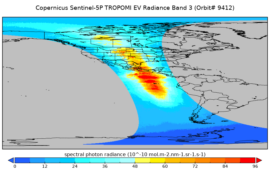
Sentinel-5P TROPOMI Radiance product band 3 (UVIS detector) L1B 5.5km x 3.5km V2 (S5P_L1B_RA_BD3_HiR) at GES DISC
National Aeronautics and Space Administration —
Starting from August 6th in 2019, Sentinel-5P TROPOMI along-track high spatial resolution (~5.5km at nadir) has been implemented. For data before August 6th of 2019,... -
Federal
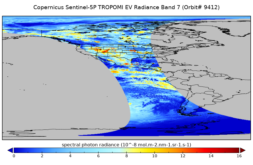
Sentinel-5P TROPOMI Radiance product band 7 (SWIR detector) L1B 5.5km x 7km V1 (S5P_L1B_RA_BD7_HiR) at GES DISC
National Aeronautics and Space Administration —
Starting from August 6th in 2019, Sentinel-5P TROPOMI along-track high spatial resolution (~5.5km at nadir) has been implemented. For data before August 6th of 2019,... -
Federal
MODIS/Terra Geolocation Fields 5-Min L1A Swath 1km NGDA
National Aeronautics and Space Administration —
The MODIS/Terra Geolocation Fields 5Min L1A Swath 1km are calculated for each 1 km MODIS Instantaneous Field of Views (IFOV) for all orbits daily (in Collection 6 and... -
Federal
Sentinel-5P TROPOMI Radiance product band 1 (UV detector) L1B 5.5km x 21km V1 (S5P_L1B_RA_BD1_HiR) at GES DISC
National Aeronautics and Space Administration —
Starting from August 6th in 2019, Sentinel-5P TROPOMI along-track high spatial resolution (~5.5km at nadir) has been implemented. For data before August 6th of 2019,... -
Federal
MODIS/Aqua Geolocation Fields 5-Min L1A Swath 1km NGDA
National Aeronautics and Space Administration —
The MODIS/Aqua Geolocation Fields 5-Min L1A Swath 1km are calculated for each 1 km MODIS Instantaneous Field of Views (IFOV) for all orbits daily (in Collection 6 and... -
Federal
HURRICANE AND SEVERE STORM SENTINEL (HS3) GLOBAL HAWK HIGH ALTITUDE MMIC SOUNDING RADIOMETER (HAMSR) V1
National Aeronautics and Space Administration —
The Hurricane and Severe Storm Sentinel (HS3) Global Hawk High Altitude MMIC Sounding Radiometer (HAMSR) dataset includes measurements gathered by the HAMSR... -
Federal
HURRICANE AND SEVERE STORM SENTINEL (HS3) FLIGHT REPORTS V1
National Aeronautics and Space Administration —
The Hurricane and Severe Storm Sentinel (HS3) Flight Reports provide information about flights flown by the WB-57 and Global Hawk aircrafts during the Hurricane and... -
Federal
CARVE: L1 Daily Flight Path Geolocation and Aircraft Position Data, Alaska, 2012-2015
National Aeronautics and Space Administration —
This data set provides high-frequency geolocation, time, height, pitch, roll, and heading information for the C-23 Sherpa aircraft during airborne campaigns over the... -
Federal
GPM GROUND VALIDATION WYOMING KING AIR CLOUD MICROPHYSICS LPVEX V1
National Aeronautics and Space Administration —
The GPM Ground Validation Wyoming King Air Cloud Microphysics LPVEx dataset includes, in addition to aircraft parameters, many scientific parameters, such as static... -
Federal
Flight Reports EPOCH V1
National Aeronautics and Space Administration —
The Flight Reports EPOCH dataset consists of flight number, purpose of flight, and flight hours logged during the East Pacific Origins and Characteristics of... -
Federal
OCO-2 Level 0 spacecraft ephemerides V10 (OCO2_Eph) at GES DISC
National Aeronautics and Space Administration —
Version 10 is the current version of the data set. Older versions will no longer be available and are superseded by Version 10. The Orbiting Carbon Observatory is the... -
Federal
GPM GROUND VALIDATION NASA ER-2 NAVIGATION DATA MC3E V1
National Aeronautics and Space Administration —
The GPM Ground Validation NASA ER-2 Navigation Data MC3E dataset contains information recorded by an on board navigation recorder (NavRec). In addition to typical... -
Federal
CAMEX-3 DC-8 METEOROLOGICAL MEASUREMENT SYSTEM (MMS) V1
National Aeronautics and Space Administration —
The CAMEX-3 Meteorological Measurement System (MMS) dataset consists of atmospheric parameters measured by the MMS instruments aboard NASA DC-8 aircraft. The MMS... -
Federal
Mission Reports IMPACTS V1
National Aeronautics and Space Administration —
The Mission Reports IMPACTS dataset consists of flight plans, plans of the day, science plans, and science summaries logged by scientists during the Investigation of... -
Federal
GPM GROUND VALIDATION FLIGHT SUMMARIES AND FLIGHT TRACKS IMAGERY MC3E V1
National Aeronautics and Space Administration —
The GPM Ground Validation Flight Summaries and Flight Tracks Imagery MC3E dataset for the Midlatitude Continental Convective Clouds Experiment (MC3E) provides...

Official websites use .gov
A
.gov website belongs to an official government
organization in the United States.
Secure .gov websites use HTTPS
A
lock (
) or https:// means you’ve safely connected to
the .gov website. Share sensitive information only on official,
secure websites.