
-
Federal
Sea Ice in the Belcher Islands, Nunavut, Canada, Version 1
National Aeronautics and Space Administration —
This data set contains interviews of three hunters from Sanikiliaq, Belcher Islands, in the territory of Nunavut, Canada. The hunters describe their observations of... -
Federal
Hurricane and Severe Storm Sentinel (HS3) Statistical Hurricane Intensity Prediction Scheme (SHIPS) Intensity V1
National Aeronautics and Space Administration —
The Hurricane and Severe Storm Sentinel (HS3) Statistical Hurricane Intensity Prediction Scheme (SHIPS) Intensity dataset was obtained from March 18, 2014 through... -
Federal
MERRA-2 tavg1_2d_flx_Nx: 2d,1-Hourly,Time-Averaged,Single-Level,Assimilation,Surface Flux Diagnostics 0.625 x 0.5 degree V5.12.4 (M2T1NXFLX) at GES DISC
National Aeronautics and Space Administration —
M2T1NXFLX (or tavg1_2d_flx_Nx) is an hourly time-averaged 2-dimensional data collection in Modern-Era Retrospective analysis for Research and Applications version 2... -
Federal
SCATSAT-1 ESDR Level 2 Modeled Ocean Surface Auxiliary Fields Version 1.0
National Aeronautics and Space Administration —
This dataset contains the first provisional release of the MEaSUREs-funded Earth Science Data Record (ESDR) of ancillary data corresponding to the SCATSAT-1 Level 2... -
Federal
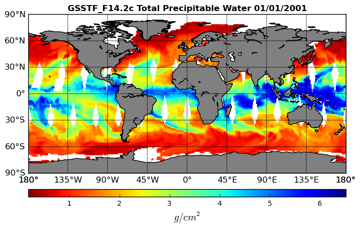
Goddard Satellite-Based Surface Turbulent Fluxes, 0.25 x 0.25 deg, Daily Grid F14 V3 (GSSTF_F14) at GES DISC
National Aeronautics and Space Administration —
These data are part of the Goddard Satellite-based Surface Turbulent Fluxes Version 3 (GSSTF3) Dataset recently produced through a MEaSURES funded project led by Dr.... -
Federal
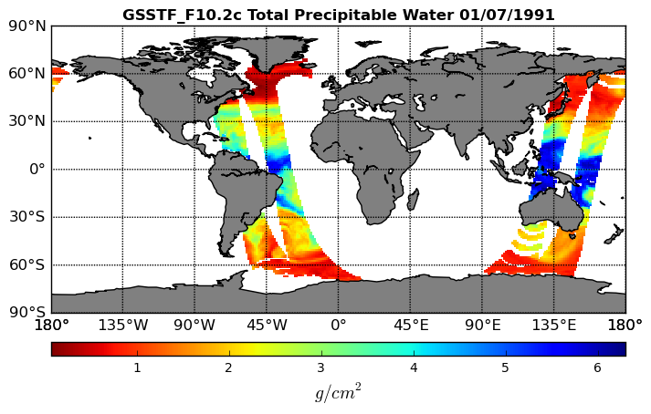
Goddard Satellite-Based Surface Turbulent Fluxes, 0.25 x 0.25 deg, Daily Grid F10 V3 (GSSTF_F10) at GES DISC
National Aeronautics and Space Administration —
These data are part of the Goddard Satellite-based Surface Turbulent Fluxes Version 3 (GSSTF3) Dataset recently produced through a MEaSURES funded project led by Dr.... -
Federal
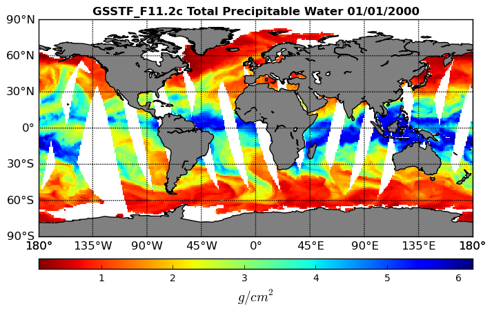
Goddard Satellite-Based Surface Turbulent Fluxes, 1x1 deg Daily Grid, Satellite F11 V2c (GSSTF_F11) at GES DISC
National Aeronautics and Space Administration —
These data are part of the Goddard Satellite-based Surface Turbulent Fluxes Version-2c (GSSTF 2c) Dataset recently produced through a MEaSURES funded project led by... -
Federal
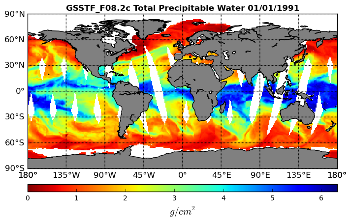
Goddard Satellite-Based Surface Turbulent Fluxes, 1x1 deg Daily Grid, Satellite F08 V2c (GSSTF_F08) at GES DISC
National Aeronautics and Space Administration —
These data are part of the Goddard Satellite-based Surface Turbulent Fluxes Version-2c (GSSTF 2c) Dataset recently produced through a MEaSURES funded project led by... -
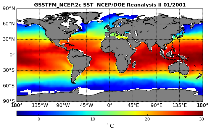
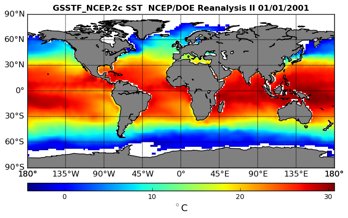
Federal
NCEP/DOE Reanalysis II in HDF-EOS5, for GSSTF2c, 1x1 deg Monthly grid V2c (GSSTFM_NCEP) at GES DISC
National Aeronautics and Space Administration —
These data are the Goddard Satellite-based Surface Turbulent Fluxes Version-2c Dataset recently produced through a MEaSURES funded project led by Dr. Chung-Lin Shie... -
Federal
ECCO Atmosphere Surface Temperature, Humidity, Wind, and Pressure - Daily Mean llc90 Grid (Version 4 Release 4)
National Aeronautics and Space Administration —
This dataset provides daily-averaged atmosphere surface temperature, humidity, winds, and pressure on the native Lat-Lon-Cap 90 (LLC90) model grid from the ECCO... -
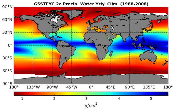
Federal
Goddard Satellite-Based Surface Turbulent Fluxes Climatology, 0.25 x 0.25 deg, Yearly Grid V3 (GSSTFYC) at GES DISC
National Aeronautics and Space Administration —
These data are the Goddard Satellite-based Surface Turbulent Fluxes Version-3 Dataset recently produced through a MEaSUREs funded project led by Dr. Chung-Lin Shie... -
Federal
NCEP/DOE Reanalysis II, for GSSTF, 0.25x0.25 deg, Monthly grid V3 (GSSTFM_NCEP) at GES DISC
National Aeronautics and Space Administration —
These data are the Goddard Satellite-based Surface Turbulent Fluxes Version 3 Dataset recently produced through a MEaSURES funded project led by Dr. Chung-Lin Shie... -
Federal
Saildrone Baja field campaign surface and ADCP measurements
National Aeronautics and Space Administration —
Saildrone is a wind and solar powered unmanned surface vehicle (USV) capable of long distance deployments lasting up to 12 months and providing high quality, near... -
Federal
NCEP/DOE Reanalysis II, for GSSTF, 0.25 x 0.25 deg, Daily Grid V3 (GSSTF_NCEP) at GES DISC
National Aeronautics and Space Administration —
These data are the Goddard Satellite-based Surface Turbulent Fluxes Version 3 Dataset recently produced through a MEaSURES funded project led by Dr. Chung-Lin Shie... -
Federal
SASSIE Arctic Field Campaign Wave Glider Data Fall 2022 Version 1
National Aeronautics and Space Administration —
The Salinity and Stratification at the Sea Ice Edge (SASSIE) project is a NASA experiment that aims to understand how salinity anomalies in the upper ocean generated... -
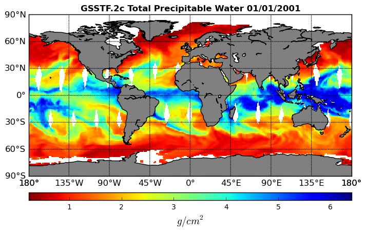
Federal
Goddard Satellite-Based Surface Turbulent Fluxes, 0.25 x 0.25 deg, Daily Grid V3 (GSSTF) at GES DISC
National Aeronautics and Space Administration —
These data are the Goddard Satellite-based Surface Turbulent Fluxes Version-3 (GSSTF3) Dataset recently produced through a MEaSUREs funded project led by Dr. Chung-... -
Federal
Goddard Satellite-Based Surface Turbulent Fluxes, 1x1 deg Daily Grid, Satellite F13 V2c (GSSTF_F13) at GES DISC
National Aeronautics and Space Administration —
These data are part of the Goddard Satellite-based Surface Turbulent Fluxes Version-2c (GSSTF 2c) Dataset recently produced through a MEaSURES funded project led by... -
Federal
SASSIE Arctic Field Campaign L1 SWIFT Data Fall 2022
National Aeronautics and Space Administration —
The Salinity and Stratification at the Sea Ice Edge (SASSIE) project is a NASA experiment that aims to understand how salinity anomalies in the upper ocean generated... -
Federal
QuikSCAT ESDR Level 2 Modeled Ocean Surface Auxiliary Fields Version 1.0
National Aeronautics and Space Administration —
This dataset contains the first provisional release of the MEaSUREs-funded Earth Science Data Record (ESDR) of ancillary data corresponding to the QuikSCAT Level 2... -
Federal
MetOp-B ASCAT ESDR Level 2 Modeled Ocean Surface Auxiliary Fields Version 1.0
National Aeronautics and Space Administration —
This dataset contains the first provisional release of the MEaSUREs-funded Earth Science Data Record (ESDR) of ancillary data corresponding to the MetOp-B ASCAT...

Official websites use .gov
A
.gov website belongs to an official government
organization in the United States.
Secure .gov websites use HTTPS
A
lock (
) or https:// means you’ve safely connected to
the .gov website. Share sensitive information only on official,
secure websites.