
-
Federal
H06995: NOS Hydrographic Survey , 1946-01-01
National Oceanic and Atmospheric Administration, Department of Commerce —
The National Oceanic and Atmospheric Administration (NOAA) has the statutory mandate to collect hydrographic data in support of nautical chart compilation for safe... -
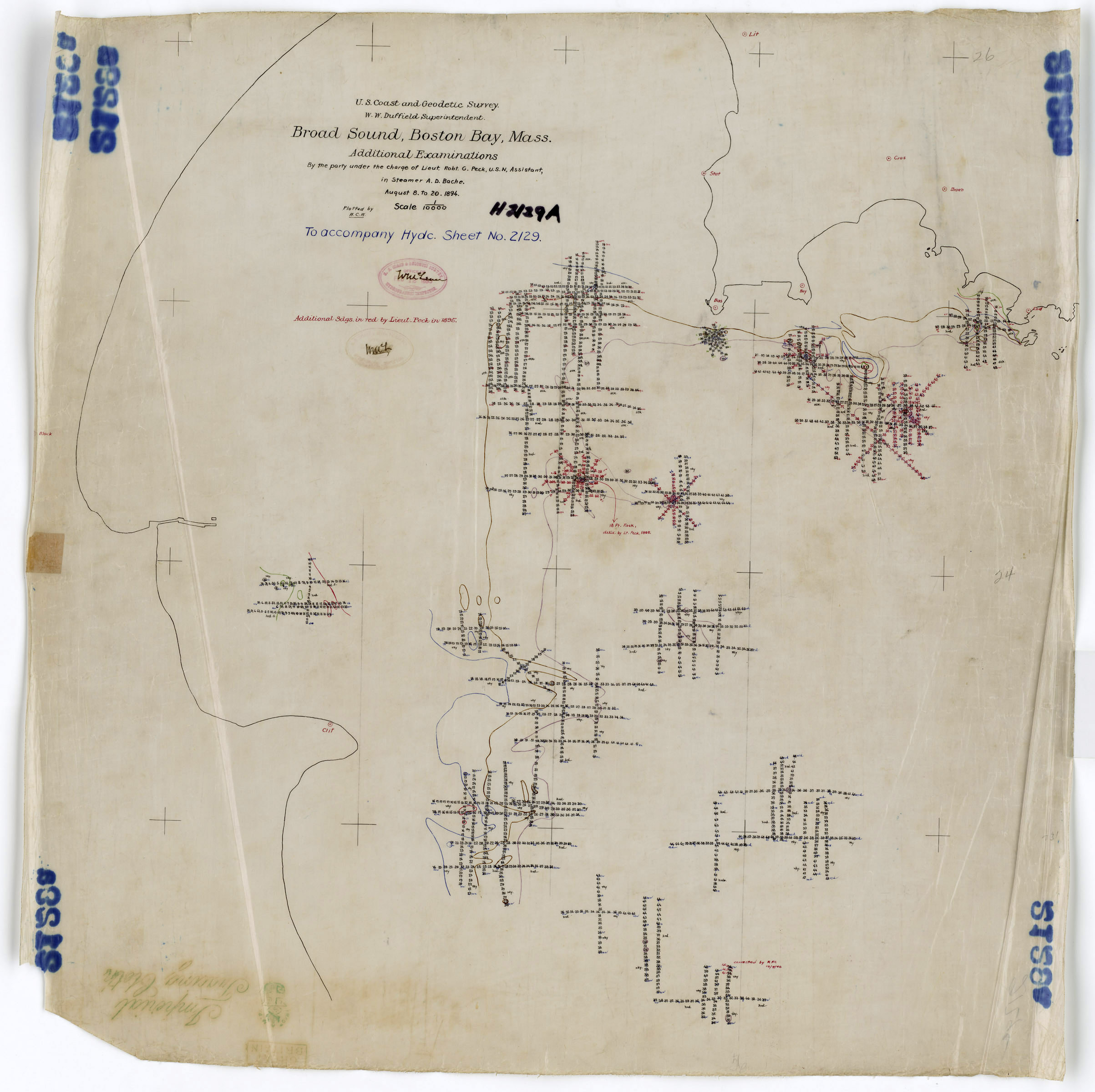
Federal
H02129B: NOS Hydrographic Survey
National Oceanic and Atmospheric Administration, Department of Commerce —
The National Oceanic and Atmospheric Administration (NOAA) has the statutory mandate to collect hydrographic data in support of nautical chart compilation for safe... -
Federal
H00178A: NOS Hydrographic Survey
National Oceanic and Atmospheric Administration, Department of Commerce —
The National Oceanic and Atmospheric Administration (NOAA) has the statutory mandate to collect hydrographic data in support of nautical chart compilation for safe... -
Federal
Location of bottom photographs from the Mini-SeaBOSS sampling system from Boston Harbor and Approaches (USGS Field Activity 04019) (BOTTOMPHOTOS, UTM 19, WGS84)
Department of the Interior —
This data set includes the locations and hotlinks to photographs of the seafloor in Boston Harbor and the harbor approaches, Massachusetts. The photos were taken... -
Federal
Shoreline Data Rescue Project of Boston, Massachusetts, MA1938A NGDA
National Oceanic and Atmospheric Administration, Department of Commerce —
These data were automated to provide an accurate high-resolution historical shoreline of Boston, Massachusetts suitable as a geographic information system (GIS) data... -
Federal
H00178: NOS Hydrographic Survey
National Oceanic and Atmospheric Administration, Department of Commerce —
The National Oceanic and Atmospheric Administration (NOAA) has the statutory mandate to collect hydrographic data in support of nautical chart compilation for safe... -
Federal
H02129C: NOS Hydrographic Survey
National Oceanic and Atmospheric Administration, Department of Commerce —
The National Oceanic and Atmospheric Administration (NOAA) has the statutory mandate to collect hydrographic data in support of nautical chart compilation for safe... -
Federal
Shorelines used to calculate shoreline change statistics Boston coastal region from Carson Beach in South Boston to Weymouth River, including the Boston Harbor Islands (Boston_shorelines.shp)
Department of the Interior —
Due to continued coastal population growth and increased threats of erosion, current data on trends and rates of shoreline movement are required to inform shoreline... -
Federal
D00176: NOS Hydrographic Survey , Boston Harbor, Massachusetts, 2012-05-11
National Oceanic and Atmospheric Administration, Department of Commerce —
The National Oceanic and Atmospheric Administration (NOAA) has the statutory mandate to collect hydrographic data in support of nautical chart compilation for safe... -
Federal
Multibeam Bathymetry 2 meter/pixel of Boston Harbor and Approaches (bh_2mmbbath)
Department of the Interior —
These data are high-resolution bathymetric measurements of the seafloor from Boston Harbor and the harbor approaches, Massachusetts. Approximately 170 km² of sidescan... -
Federal
Defined Map Units of the seafloor of Boston Harbor and Approaches (BOTTOMTYPE, UTM 19, WGS84)
Department of the Interior —
This data is a qualitatively-derived interpretative polygon shapefile defining the bottom types of the seafloor from Boston Harbor and the harbor approaches,... -
Federal
ArcInfo Grid of the 30 meter pixel Composite Bathymetry of Boston Harbor and Approaches (BH_30MBATH, UTM 19, WGS84)
Department of the Interior —
These data are high-resolution bathymetric measurements of the seafloor from Boston Harbor and the harbor approaches, Massachusetts. Approximately 170 km square of... -
Federal
Survey lines of the video and photos from the mini-SEABOSS sampling system acquired in Boston Harbor and approaches (surveylines_vid)
Department of the Interior —
These data are the trackline from the seafloor photograph and video survey conducted September 2004 using the mini-SeaBOSS sampling system on the R/V Rafael in Boston... -
Federal
Survey lines of the sidescan sonar system of data collected in Boston Harbor and Approaches (surveylines_sss)
Department of the Interior —
These data are the trackline from the high-resolution acoustic backscatter measurements of the seafloor from Boston Harbor and the harbor approaches, Massachusetts.... -
Federal
Shorelines of the Greater Boston coastal region from the southern side of Cape Ann, Massachusetts to Sandy Neck Beach in Sandwich, Massachusetts, used in shoreline change analysis (GreaterBoston_shorelines.shp)
Department of the Interior —
Sandy ocean beaches are a popular recreational destination, often surrounded by communities containing valuable real estate. Development is on the rise despite the... -
Federal
Backscatter Imagery from Sidescan Sonar 5 meter/pixel of Boston Harbor and Approaches (bh_5mBS.tif)
Department of the Interior —
These data are high-resolution acoustic backscatter measurements of the seafloor from Boston Harbor and the harbor approaches, Massachusetts. Approximately 170 km² of... -
Federal
Hillshade of Multibeam Bathymetry 2 meter/pixel of Boston Harbor and Approaches (bh_2mmbhsf)
Department of the Interior —
These data are high-resolution bathymetric measurements of the seafloor from Boston Harbor and the harbor approaches, Massachusetts. Approximately 170 km² of sidescan... -
Federal
1 meter resolution GeoTIFF image of the sidescan sonar backscatter imagery of Boston Harbor and Approaches (BH_1MBS.TIF, UTM 19, WGS84)
Department of the Interior —
These data are high-resolution acoustic backscatter measurements of the seafloor from Boston Harbor and the harbor approaches, Massachusetts. Approximately 170 km... -
Federal
MA Bias_Feature – Feature class containing Massachusetts proxy-datum bias information to be used in the Digital Shoreline Analysis System.
Department of the Interior —
The Digital Shoreline Analysis System (DSAS) is a freely available software application that works within the Environmental Systems Research Institute (ESRI)... -
Federal
Surficial sediment data from Boston Harbor collected during USGS Field Activity 04019 (SEDGRABS, UTM 19, WGS84)
Department of the Interior —
This data set includes the locations, identifiers, grain-size data and(or) textural descriptions of surficial sediments collected at stations based on topographic and...

Official websites use .gov
A
.gov website belongs to an official government
organization in the United States.
Secure .gov websites use HTTPS
A
lock (
) or https:// means you’ve safely connected to
the .gov website. Share sensitive information only on official,
secure websites.