
-
Federal
Moderate Resolution Imaging Spectroradiometer (MODIS) - Terra NGDA
National Aeronautics and Space Administration —
This dataset represents multiple products archived at the multiple archive centers for the MODIS (Moderate Resolution Imaging Spectroradiometer) instrument aboard the... -
Federal
Multilayer Greenland Ice Surface Temperature, Surface Albedo, and Water Vapor from MODIS V001 NGDA
National Aeronautics and Space Administration —
This multilayer data set includes standard MODIS Collection 6.1 ice surface temperature (IST) and derived melt map, as well as MODIS Collection 6.0 albedo and water... -
Federal
MODIS/Terra Temperature and Water Vapor Profiles 5-Min L2 Swath 5km NGDA
National Aeronautics and Space Administration —
The MODIS/Terra Temperature and Water Vapor Profiles 5-Min L2 Swath 5km (MOD07_L2) product consists of a numbers of parameters related to atmospheric stability,... -
Federal
MODIS/Aqua Aerosol Cloud Water Vapor Ozone Daily L3 Global 1Deg CMG NGDA
National Aeronautics and Space Administration —
The MODIS/Aqua Aerosol Cloud Water Vapor Ozone Daily L3 Global 1Deg CMG product (MYD08_D3) contains daily 1 x 1 degree grid average values of atmospheric parameters... -
Federal
MODIS/Terra Total Precipitable Water Vapor 5-Min L2 Swath 1km and 5km - NRT NGDA
National Aeronautics and Space Administration —
The MODIS Adaptive Processing System (MODAPS) is currently generating an improved Collection 6.1 (061) for all MODIS Level-1 (L1) and higher-level Level-2 (L2) &... -
Federal
MODIS/Aqua Temperature and Water Vapor Profiles 5-Min L2 Swath 5km NGDA
National Aeronautics and Space Administration —
The MODIS/Aqua Temperature and Water Vapor Profiles 5-Min L2 Swath 5km (MYD07_L2) product consists of a numbers of parameters related to atmospheric stability,... -
Federal
Moderate Resolution Imaging Spectroradiometer (MODIS) - Terra NGDA
National Aeronautics and Space Administration —
This dataset represents multiple products archived at the multiple archive centers for the MODIS (Moderate Resolution Imaging Spectroradiometer) instrument aboard the... -
Federal
CERES and GEO-Enhanced TOA, Within-Atmosphere, and Surface Fluxes Clouds and Aerosols Monthly Terra Edition4A NGDA
National Aeronautics and Space Administration —
CER_SYN1deg-Month_Terra-MODIS_Edition4A is the Clouds and the Earth's Radiant Energy System (CERES) and and geostationary (GEO)-Enhanced Top of Atmosphere (TOA),... -
Federal
CERES and GEO-Enhanced TOA, Within-Atmosphere and Surface Fluxes, Clouds and Aerosols Three-Hourly Terra-NPP Edition1A NGDA
National Aeronautics and Space Administration —
CER_SYN1deg-3Hour_Terra-NPP_Edition1A is the Clouds and the Earth's Radiant Energy System (CERES) and geostationary (GEO)-Enhanced Top-of-Atmosphere (TOA), Within-... -
Federal
MODIS/Aqua Total Precipitable Water Vapor 5-Min L2 Swath 1km and 5km - NRT NGDA
National Aeronautics and Space Administration —
The MODIS Adaptive Processing System (MODAPS) is currently generating an improved Collection 6.1 (061) for all MODIS Level-1 (L1) and higher-level Level-2 (L2) and... -
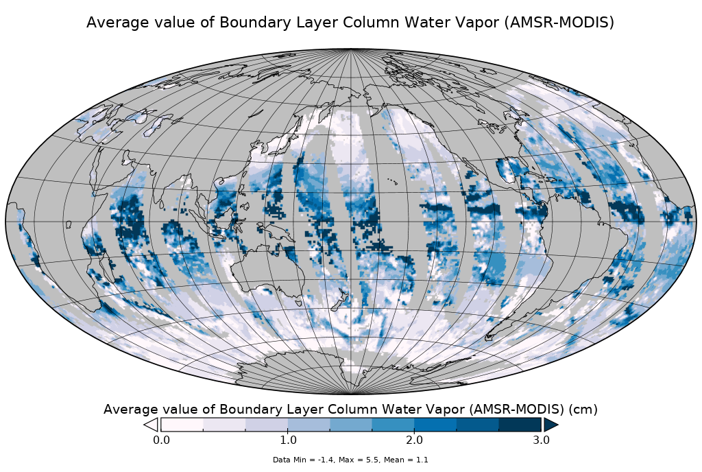
Federal
AMSR-MODIS Boundary Layer Water Vapor L3 Monthly 1 degree x 1 degree V1 (AMMBLWV) at GES DISC NGDA
National Aeronautics and Space Administration —
This data set provides an estimate the marine boundary layer water vapor beneath uniform cloud fields. Microwave radiometry from AMSR-E and AMSR-2 provides the total... -
Federal
CERES and GEO-Enhanced TOA, Within-Atmosphere and Surface Fluxes, Clouds and Aerosols Monthly Terra-NOAA20 Edition4A NGDA
National Aeronautics and Space Administration —
CER_SYN1deg-Month_Terra-NOAA20_Edition4A is the Clouds and the Earth's Radiant Energy System (CERES) and geostationary (GEO)-Enhanced Top of Atmosphere (TOA), Within-... -
Federal
MODIS/Terra Net Evapotranspiration Gap-Filled 8-Day L4 Global 500m SIN Grid V061 NGDA
National Aeronautics and Space Administration —
The MOD16A2GF Version 6.1 Evapotranspiration/Latent Heat Flux (ET/LE) product is a year-end gap-filled 8-day composite dataset produced at 500 meter (m) pixel... -
Federal
CERES A-Train Integrated CALIPSO, CloudSat, CERES, and MODIS (CCCM) Merged Release B1 NGDA
National Aeronautics and Space Administration —
CER-NEWS_CCCM_Aqua-FM3-MODIS-CAL-CS_RelB1 is the Clouds and the Earth's Radiant Energy System (CERES) NASA Energy and Water cycle Study (NEWS) A-Train Integrated... -
Federal
MODIS/Aqua Temperature and Water Vapor Profiles 5-Min L2 Swath 5km - NRT NGDA
National Aeronautics and Space Administration —
The level-2 MODIS Temperature and Water Vapor Profile Product MYD07_L2 consists of 30 gridded parameters related to atmospheric stability, atmospheric temperature and... -
Federal
CERES and GEO-Enhanced TOA, Within-Atmosphere and Surface Fluxes, Clouds and Aerosols 1-Hourly Terra-NOAA20 Edition4A NGDA
National Aeronautics and Space Administration —
CER_SYN1deg-1Hour_Terra-NOAA20-MODIS_Edition4A is the Clouds and the Earth's Radiant Energy System (CERES) and geostationary (GEO) Top-of-Atmosphere (TOA) Within-... -
Federal
CERES and GEO-Enhanced TOA, Within-Atmosphere and Surface Fluxes, Clouds and Aerosols Monthly-Averaged 1-Hourly Terra-NPP Edition1A NGDA
National Aeronautics and Space Administration —
CER_SYN1deg-MHour_Terra-NPP_Edition1A is the Clouds and the Earth's Radiant Energy System (CERES) and geostationary (GEO)-Enhanced Top-of-Atmosphere (TOA), Within-... -
Federal
AMSR-MODIS Boundary Layer Water Vapor L3 Daily 1 degree x 1 degree V2 (AMDBLWV) at GES DISC NGDA
National Aeronautics and Space Administration —
Version 2 is the current version of this dataset. Version 2 uses an improved methodology to screen out high clouds. This data set provides an estimate the marine... -
Federal
CERES and GEO-Enhanced TOA, Within-Atmosphere and Surface Fluxes, Clouds and Aerosols 3-Hourly Terra-Aqua Edition4A NGDA
National Aeronautics and Space Administration —
CER_SYN1deg-3Hour_Terra-Aqua-MODIS_Edition4A is the Clouds and the Earth's Radiant Energy System (CERES) and geostationary (GEO)-Enhanced Top of Atmosphere (TOA),... -
Federal
MODIS/Terra Total Precipitable Water Vapor 5-Min L2 Swath 1km and 5km NGDA
National Aeronautics and Space Administration —
The MODIS/Terra Total Precipitable Water Vapor 5-Min L2 Swath 1km and 5km (MOD05_L2) product consists of atmospheric column water-vapor amounts. This product is...

Official websites use .gov
A
.gov website belongs to an official government
organization in the United States.
Secure .gov websites use HTTPS
A
lock (
) or https:// means you’ve safely connected to
the .gov website. Share sensitive information only on official,
secure websites.