
-
Federal
LBA-ECO LC-14 Modeled Deforestation Scenarios, Amazon Basin: 2002-2050
National Aeronautics and Space Administration —
This data set provides the results of the two modeled scenarios for future patterns of deforestation across the Amazon Basin from 2002 to 2050. This larger defined... -
Federal
LBA-ECO LC-22 Post-deforestation Land Use, Mato Grosso, Brazil: 2001-2005 NGDA
National Aeronautics and Space Administration —
This data set provides (1) areal estimates of deforestation events (>25 ha) that were identified from 2001-2004 in Mato Grosso by the Brazilian Institute for Space... -
Federal
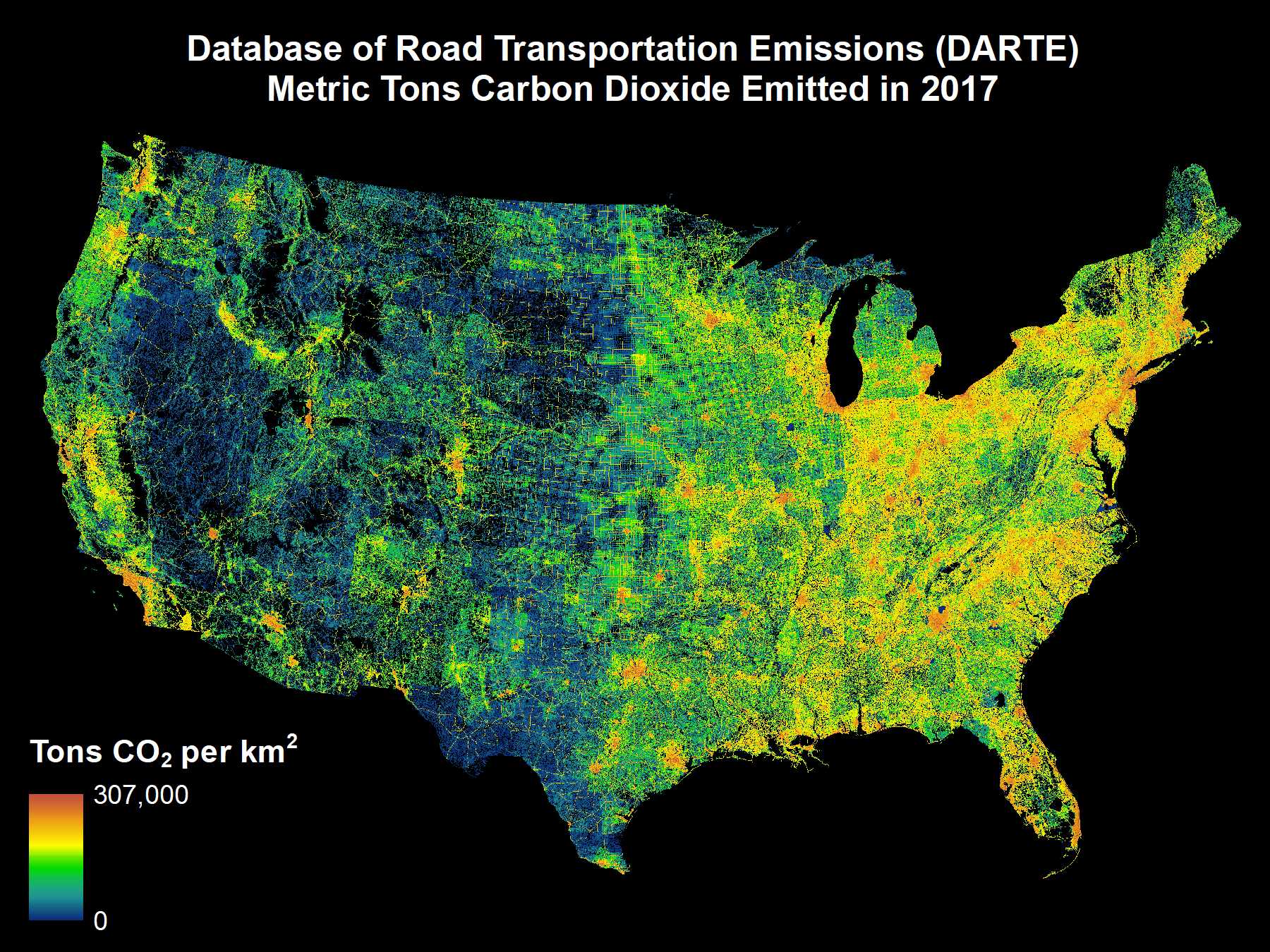
DARTE Annual On-road CO2 Emissions on a 1-km Grid, Conterminous USA, V2, 1980-2017
National Aeronautics and Space Administration —
This data set provides a 38-year, 1-km resolution inventory of annual on-road CO2 emissions for the conterminous United States based on roadway-level vehicle traffic... -
Federal
NAFD-ATT Forest Canopy Cover Loss from Landsat, CONUS, 1986-2010
National Aeronautics and Space Administration —
Characterizing the cause of forest canopy changes through time is fundamental to understanding current and future forest functions. A better understanding of forest... -
Federal
ABoVE: Environmental Conditions and Subsistence Resource Access, Alaska, 2016-2017
National Aeronautics and Space Administration —
This dataset provides descriptions and photos of environmental conditions that impacted availability to subsistence resources by residents in nine rural communities... -
Federal
Net Radiation and Albedo from MODIS for Xingu River Basin, Brazil, 2000-2012 NGDA
National Aeronautics and Space Administration —
This dataset provides daily average land surface net radiation (Rnet) as an 8-day time series at approximately 0.5 km resolution for the upper Xingu River Basin in... -
Federal
Global Gas Flare Survey by Infrared Imaging, VIIRS Nightfire, 2012-2019
National Aeronautics and Space Administration —
This dataset contains annual global flare site surveys from 2012-2019 derived from Visible Infrared Imaging Radiometer Suite (VIIRS) on the Suomi National Polar... -
Federal
SAFARI 2000 Global Burned Area Map, 1-km, Southern Africa, 2000
National Aeronautics and Space Administration —
The Global Burned Area 2000 initiative (GBA2000) was launched by the Global Vegetation Mapping Unit of the Joint Research Centre of the European Commission, in... -
Federal
ABoVE: Active Layer Soil Characteristics at Selected Sites Across Alaska
National Aeronautics and Space Administration —
This dataset provides soil active layer characteristics from nine locations across Alaska. Soil samples were collected in 2016 except for one site which was sampled... -
Federal
Vulcan: High-Resolution Annual Fossil Fuel CO2 Emissions in USA, 2010-2015, Version 3
National Aeronautics and Space Administration —
The Vulcan version 3.0 annual dataset provides estimates of annual carbon dioxide (CO2) emissions from the combustion of fossil fuels (FF) and CO2 emissions from... -
Federal
Burned and Unburned Field Site Data, Noatak, Seward, and North Slope, AK, 2016-2018
National Aeronautics and Space Administration —
This dataset includes field measurements from unburned and burned 10 m x 10 m and 1 m x 1 m plots in the Noatak, Seward, and North Slope regions of the Alaskan tundra... -
Federal
ABoVE: Synthesis of Burned and Unburned Forest Site Data, AK and Canada, 1983-2016
National Aeronautics and Space Administration —
This dataset is a synthesis of field plot characterization data, derived above-ground and below-ground combusted carbon, and acquired Fire Weather Index (FWI) System... -
Federal
CMS: Mangrove Forest Cover Extent and Change across Major River Deltas, 2000-2016
National Aeronautics and Space Administration —
This dataset provides estimates of mangrove extent for 2016, and mangrove change (gain or loss) from 2000 to 2016, in major river delta regions of eight countries:... -
Federal
ABoVE: Post-Fire and Unburned Vegetation Community and Field Data, NWT, Canada, 2017
National Aeronautics and Space Administration —
This dataset provides vegetation community characteristics, soil moisture, and biophysical data collected in 2017 from 11 study sites in the ABoVE Study area. The 11... -
Federal
Remote Sensing Data Before and After California Rim and King Forest Fires, 2010-2015
National Aeronautics and Space Administration —
This data set provides high-resolution surface reflectance, thermal imagery, burn severity metrics, and LiDAR-derived structural measures of forested areas in the... -
Federal
ABoVE: Post-Fire and Unburned Vegetation Community and Field Data, NWT, Canada, 2018
National Aeronautics and Space Administration —
This dataset provides vegetation community characteristics and biophysical data collected in 2018 from areas that were burned by wildfire in 2014 and 2015, and from... -
Federal
NACP: Forest Carbon Stocks, Fluxes and Productivity Estimates, Western USA, 1979-2099
National Aeronautics and Space Administration —
This dataset contains annual estimates of carbon stocks, fluxes, and productivity over forested land in 11 states of the western USA (Arizona, California, Colorado,... -
Federal
Post-fire Recovery of Soil Organic Layer Carbon in Canadian Boreal Forests, 2015-2018
National Aeronautics and Space Administration —
This dataset provides site moisture, soil organic layer thickness, soil organic carbon, nonvascular plant functional group, stand dominance, ecozone, time-after-fire,... -
Federal
Export and Leaching of Carbon and Nitrogen from Mississippi River Basin, 1901-2099
National Aeronautics and Space Administration —
This dataset provides estimates for export and leaching of dissolved inorganic carbon (DIC), dissolved organic carbon (DOC), total organic carbon (TOC), particulate... -
Federal
ABoVE: Burned Area, Depth, and Combustion for Alaska and Canada, 2001-2019 NGDA
National Aeronautics and Space Administration —
This dataset provides annual gridded estimates of fire locations and associated burn fraction per pixel for Alaska and Canada at approximately 500 m spatial...

Official websites use .gov
A
.gov website belongs to an official government
organization in the United States.
Secure .gov websites use HTTPS
A
lock (
) or https:// means you’ve safely connected to
the .gov website. Share sensitive information only on official,
secure websites.