
-
Federal
Maritime Limits and Boundaries of United States of America NGDA 52 recent views
National Oceanic and Atmospheric Administration, Department of Commerce —
NOAA is responsible for depicting on its nautical charts the limits of the 12 nautical mile Territorial Sea, 24 nautical mile Contiguous Zone, and 200 nautical mile... -
Federal
Marine Animal Incident Database 37 recent views
National Oceanic and Atmospheric Administration, Department of Commerce —
Large whale stranding, death, ship strike and entanglement incidents are all recorded to monitor the health of each population and track anthropogenic factors that... -
Federal
Eastern Canada 3 arc-second Bathymetric Digital Elevation Model
National Oceanic and Atmospheric Administration, Department of Commerce —
NOAA's National Centers for Environmental Information is building high-resolution digital elevation models (DEMs) for select U.S. coastal regions. These integrated... -
Federal
Bar Harbor, Maine 1/3 Arc-second NAVD 88 Coastal Digital Elevation Model
National Oceanic and Atmospheric Administration, Department of Commerce —
NOAA's National Geophysical Data Center (NGDC) is building high-resolution digital elevation models (DEMs) for select U.S. coastal regions. These integrated... -
Federal
Atlantic Salmon Telemetry Monitoring
National Oceanic and Atmospheric Administration, Department of Commerce —
Annual telemetry data are collected as part of specific projects (assessments within watersheds) or as opportunistic efforts to characterize Atlantic salmon smolt... -
Federal
Spring Bottom Trawl Survey
National Oceanic and Atmospheric Administration, Department of Commerce —
The standardized NEFSC Spring Bottom Trawl Survey was initiated in 1968 and covered an area from Cape Hatteras, NC, to Nova Scotia, Canada, at depths >27m.... -
Federal
H06565: NOS Hydrographic Survey , 1940-12-31
National Oceanic and Atmospheric Administration, Department of Commerce —
The National Oceanic and Atmospheric Administration (NOAA) has the statutory mandate to collect hydrographic data in support of nautical chart compilation for safe... -
Federal
W00587: NOS Hydrographic Survey , 2019-08-29
National Oceanic and Atmospheric Administration, Department of Commerce —
The National Oceanic and Atmospheric Administration (NOAA) has the statutory mandate to collect hydrographic data in support of nautical chart compilation for safe... -
Federal
Gulf of Maine Cooperative Bottom Longline Survey Database
National Oceanic and Atmospheric Administration, Department of Commerce —
This database is for a bottom longline (fixed gear) survey executed in the western and central Gulf of Maine targeting complex rocky habitats. The survey is operated... -
Federal
Monthly Composite Chlorophyll Concentrations - Gulf of Maine
National Oceanic and Atmospheric Administration, Department of Commerce —
This personal geodatabase contains raster images of chlorophyll concentrations in the Gulf of Maine. These raster images are monthly composites, and were calculated... -
Federal
H06567: NOS Hydrographic Survey , 1940-12-31
National Oceanic and Atmospheric Administration, Department of Commerce —
The National Oceanic and Atmospheric Administration (NOAA) has the statutory mandate to collect hydrographic data in support of nautical chart compilation for safe... -
Federal
H11421: NOS Hydrographic Survey , Wildcat Knoll Mapping Project, Massachusetts, 2005-08-07
National Oceanic and Atmospheric Administration, Department of Commerce —
The National Oceanic and Atmospheric Administration (NOAA) has the statutory mandate to collect hydrographic data in support of nautical chart compilation for safe... -
Federal
Regional Hydrodynamic Model Outputs of the NOAA Gulf of Maine Operational Forecast System (GoMOFS)
National Oceanic and Atmospheric Administration, Department of Commerce —
NOAA's National Ocean Service (NOS) has developed a Gulf of Maine Operational Forecast System (GoMOFS). Based on Rutgers University's Regional Ocean Modeling System... -
Federal
Grand Seasonal Average Turbidity Geotifs (using SeaWiFS 670 band) of Stellwagen Bank National Marine Sanctuary
National Oceanic and Atmospheric Administration, Department of Commerce —
Inter-annual Mean seasonal turbidity imagery - Each image represents one calendar month -
Federal
Gulf of Maine - Land and Water Masks (as rasters and polygons) for the Remotely Sensed Data
National Oceanic and Atmospheric Administration, Department of Commerce —
This personal geodatabase contains land and water masks (as rasters and polygons) for the remotely sensed data. It also contains a polygon feature class named:... -
Federal
Atlantic Herring Acoustic Surveys
National Oceanic and Atmospheric Administration, Department of Commerce —
The NEFSC Advanced Sampling Technologies Research Group conducts annual fisheries acoustic surveys using state-of-the-art acoustic, midwater trawling, and underwater... -
Federal
Historical Survey Data Archive
National Oceanic and Atmospheric Administration, Department of Commerce —
To preserve NEFSC historical data, images of biological and oceanographic data sheets (1948-1975) were scanned to digital format and can be queried through a portal... -
Federal
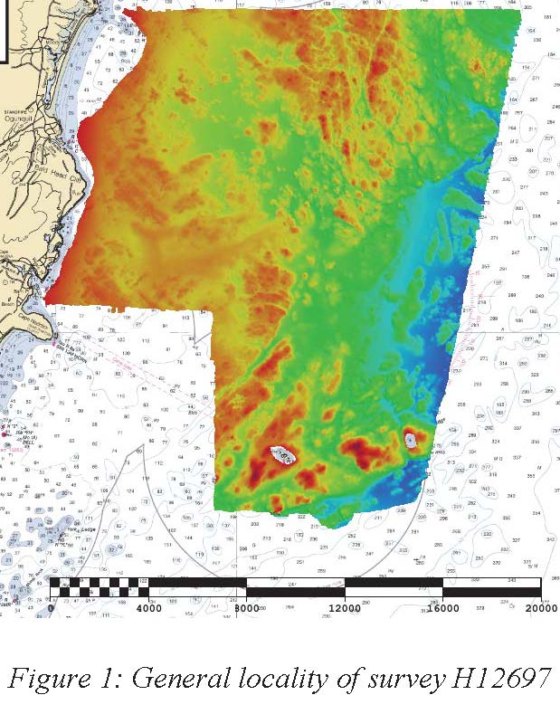
H12697: NOS Hydrographic Survey , Approaches to Portsmouth, NH, 2014-05-29
National Oceanic and Atmospheric Administration, Department of Commerce —
The National Oceanic and Atmospheric Administration (NOAA) has the statutory mandate to collect hydrographic data in support of nautical chart compilation for safe... -
Federal
W00590: NOS Hydrographic Survey , 2020-08-20
National Oceanic and Atmospheric Administration, Department of Commerce —
The National Oceanic and Atmospheric Administration (NOAA) has the statutory mandate to collect hydrographic data in support of nautical chart compilation for safe...

Official websites use .gov
A
.gov website belongs to an official government
organization in the United States.
Secure .gov websites use HTTPS
A
lock (
) or https:// means you’ve safely connected to
the .gov website. Share sensitive information only on official,
secure websites.