
-
Federal
ABoVE: Active Layer Thickness from Airborne L- and P- band SAR, Alaska, 2017, Ver. 3
National Aeronautics and Space Administration —
This dataset provides estimates of seasonal subsidence, active layer thickness (ALT), the vertical soil moisture profile, and uncertainties at a 30 m resolution for... -
Federal
ABoVE: Annual Thaw Slump Expansion on East Fork Chandalar River, Alaska, 2008-2017
National Aeronautics and Space Administration —
This dataset provides a time series of spatial data showing the expansion of a thaw slump on the East Fork Chandalar River near the community of Venetie, Alaska, from... -
Federal
Arctic Circumpolar Distribution and Soil Carbon of Thermokarst Landscapes, 2015
National Aeronautics and Space Administration —
This data set provides the distribution of thermokarst landscapes in the boreal and tundra ecoregions within the northern circumpolar permafrost zones. This dataset... -
Federal
Arctic Vegetation Plots from Pingo Communities, North Slope, Alaska, 1984-1986
National Aeronautics and Space Administration —
This data set provides vegetation species and vegetation plot data collected between 1983 and 1985 from 293 study plots on 41 pingos on the North Slope of Alaska. The... -
Federal
Arctic Vegetation Plots Legacy Project Barter Island and Point Barrow, Alaska, 1994
National Aeronautics and Space Administration —
This dataset provides vegetation cover and environmental plot and soil data collected at two U.S. Air Force sites at Barter Island (BI) and Point Barrow (B), on the... -
Federal
Gridded Winter Soil CO2 Flux Estimates for pan-Arctic and Boreal Regions, 2003-2100
National Aeronautics and Space Administration —
This dataset provides gridded estimates of soil CO2 flux (g C m-2 d-1) for the winter non-growing season (NGS) across pan-Arctic and Boreal permafrost regions (>49... -
Federal
Synthesis of Winter In Situ Soil CO2 Flux in pan-Arctic and Boreal Regions, 1989-2017 NGDA
National Aeronautics and Space Administration —
This dataset provides a synthesis of winter ( September-April) in situ soil CO2 flux measurement data from locations across pan-Arctic and Boreal permafrost regions.... -
Federal
ABoVE: Permafrost Measurements and Distribution Across the Y-K Delta, Alaska, 2016
National Aeronautics and Space Administration —
This dataset provides field observations of thaw depth and dominant vegetation types, a LiDAR-derived elevation map, and permafrost distribution and probability maps... -
Federal
A Concise Experiment Plan for the Arctic-Boreal Vulnerability Experiment
National Aeronautics and Space Administration —
This document presents the Concise Experiment Plan for NASA's Arctic-Boreal Vulnerability Experiment (ABoVE) to serve as a guide to the Program as it identifies the... -
Federal
Pre-ABoVE: Remotely Sensed Active Layer Thickness, Barrow, Alaska, 2006-2011
National Aeronautics and Space Administration —
Active layer thickness (ALT) is a critical parameter for monitoring the status of permafrost that is typically measured at specific locations using probing, in situ... -
Federal
Maps of Vegetation, NDVI, Snow and Thaw Depths: North Slope, Alaska and NWT, Canada
National Aeronautics and Space Administration —
This dataset includes vegetation cover maps, Normalized Difference Vegetation Index (NDVI) maps, snow depth and thaw depth data that were obtained as part of a... -
Federal
Pre-ABoVE: Remotely Sensed Active Layer Thickness, Prudhoe Bay, Alaska, 1992-2000
National Aeronautics and Space Administration —
Active layer thickness (ALT) is a critical parameter for monitoring the status of permafrost that is typically measured at specific locations using probing, in situ... -
Federal
BOREAS TF-10 NSA-Fen Tower Flux and Meteorological Data
National Aeronautics and Space Administration —
The flux and ancillary data collected at the NSA-Fen tower flux site by the TF-10 group. -
Federal
BOREAS TE-20 Soils Data over the NSA-MSA and Tower Sites in Vector Format
National Aeronautics and Space Administration —
Vector layers of soil maps. The vector layers were converted to ARC/INFO EXPORT files. These data cover 1-km diameters around each of the NSA tower sites and another... -
Federal
ABoVE: Soil Moisture and Active Layer Thickness in Alaska and NWT, Canada, 2008-2020
National Aeronautics and Space Administration —
This dataset provides soil thaw depth and moisture (STDM) measurements and dielectric properties measured by different research teams at sites in Alaska, U.S., and... -
Federal
Pre-ABoVE: Ground-penetrating Radar Measurements of ALT on the Alaska North Slope
National Aeronautics and Space Administration —
This data set includes estimates of permafrost Active Layer Thickness (ALT; cm), and calculated uncertainties, derived using a ground-penetrating radar (GPR) system... -
Federal
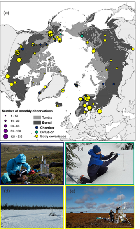
The ABCflux Database: Arctic-Boreal CO2 Flux and Site Environmental Data, 1989-2020
National Aeronautics and Space Administration —
This Arctic-Boreal CO2 fluxes (ABCflux) dataset contains monthly aggregates of terrestrial net ecosystem CO2 exchange and its derived partitioned component fluxes:... -
Federal
ABoVE: Active Layer Thickness from Remote Sensing Permafrost Model, Alaska, 2001-2015 NGDA
National Aeronautics and Space Administration —
This dataset provides annual estimates of active layer thickness (ALT) at 1 km resolution across Alaska from 2001-2015. The ALT was estimated using a remote sensing-... -
Federal
ABoVE: Active Layer Soil Characterization of Permafrost Sites, Northern Alaska, 2018
National Aeronautics and Space Administration —
This dataset provides in situ soil measurements including soil dielectric properties, temperature, and moisture profiles, active layer thickness (ALT), and... -
Federal
ABoVE: Active Layer and Soil Moisture Properties from AirMOSS P-band SAR in Alaska
National Aeronautics and Space Administration —
This dataset provides estimates of soil geophysical properties derived from Airborne Microwave Observatory of Subcanopy and Subsurface (AirMOSS) P-band polarimetric...

Official websites use .gov
A
.gov website belongs to an official government
organization in the United States.
Secure .gov websites use HTTPS
A
lock (
) or https:// means you’ve safely connected to
the .gov website. Share sensitive information only on official,
secure websites.