
-
Federal
Aquarius CAP Level 2 Sea Surface Salinity, Wind Speed & Direction Data V5.0
National Aeronautics and Space Administration —
The version 5.0 Aquarius CAP Level 2 product contains the fourth release of the AQUARIUS/SAC-D orbital/swath data based on the Combined Active Passive (CAP)... -
Federal
Aquarius Official Release Level 2 Sea Surface Salinity & Wind Speed Data V5.0
National Aeronautics and Space Administration —
The version 5.0 Aquarius Level 2 product is the official third release of the orbital/swath data from AQUARIUS/SAC-D mission. The Aquarius Level 2 data set contains... -
Federal
JPL SMAP Level 3 CAP Sea Surface Salinity Standard Mapped Image 8-Day Running Mean V5.0 Validated Dataset
National Aeronautics and Space Administration —
This is the PI-produced JPL SMAP-SSS V5.0 CAP, 8-day running mean, level 3 mapped, sea surface salinity (SSS) product from the NASA Soil Moisture Active Passive... -
Federal
Saildrone Baja field campaign surface and ADCP measurements
National Aeronautics and Space Administration —
Saildrone is a wind and solar powered unmanned surface vehicle (USV) capable of long distance deployments lasting up to 12 months and providing high quality, near... -
Federal
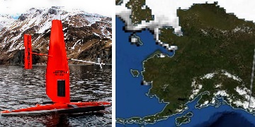
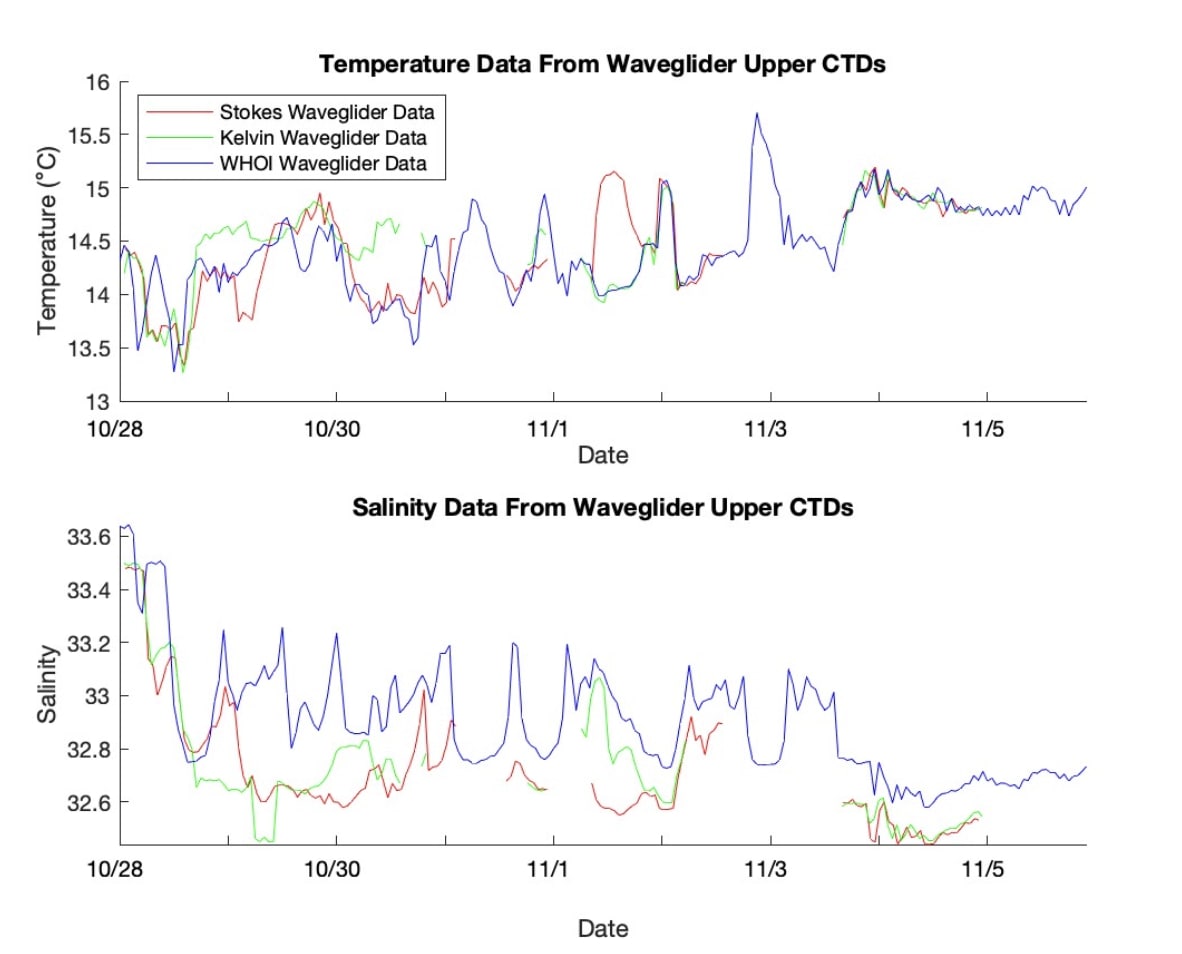
SASSIE Arctic Field Campaign Wave Glider Data Fall 2022 Version 1
National Aeronautics and Space Administration —
The Salinity and Stratification at the Sea Ice Edge (SASSIE) project is a NASA experiment that aims to understand how salinity anomalies in the upper ocean generated... -
Federal
SASSIE Arctic Field Campaign L1 SWIFT Data Fall 2022
National Aeronautics and Space Administration —
The Salinity and Stratification at the Sea Ice Edge (SASSIE) project is a NASA experiment that aims to understand how salinity anomalies in the upper ocean generated... -
Federal
JPL SMAP Level 3 CAP Sea Surface Salinity Standard Mapped Image Monthly V5.0 Validated Dataset
National Aeronautics and Space Administration —
This is the PI-produced JPL SMAP-SSS V5.0 CAP, level 3, monthly mapped sea surface salinity (SSS) product from the NASA Soil Moisture Active Passive (SMAP)... -
Federal
Saildrone 2022 Arctic field campaign for the Multi-Sensor Improved SST (MISST) project
National Aeronautics and Space Administration —
Saildrone is a wind and solar powered unmanned surface vehicle (USV) capable of long distance deployments lasting up to 12 months and providing high quality, near... -
Federal
S-MODE Waveglider Observations
National Aeronautics and Space Administration —
This dataset contains waveglider observations from the Sub-Mesoscale Ocean Dynamics Experiment (S-MODE) field campaign. The experiment was conducted approximately 300... -
Federal
Waveglider data for the SPURS-1 N. Atlantic field campaign
National Aeronautics and Space Administration —
The SPURS (Salinity Processes in the Upper Ocean Regional Study) project is an oceanographic process study and associated field program that aim to elucidate key... -
Federal
SPURS-2 Central mooring CTD, surface flux and meterorological data for the E. Tropical Pacific field campaign
National Aeronautics and Space Administration —
The SPURS (Salinity Processes in the Upper Ocean Regional Study) project is NASA-funded oceanographic process study and associated field program that aim to elucidate... -
Federal
SPURS-1 research vessel Meteorological series data for N. Atlantic Endeavor cruises
National Aeronautics and Space Administration —
The SPURS (Salinity Processes in the Upper Ocean Regional Study) project is an oceanographic process study and associated field program that aim to elucidate key... -
Federal
Parametrized Rain Impact Model for SMAP L2 V1.0
National Aeronautics and Space Administration —
This is the PI-produced SMAP-SSS, level 2B CAP, validated sea surface salinity and extreme winds orbital/swath product from the NASA Soil Moisture Active Passive... -
Federal
SPURS-2 Waveglider data for the E. Tropical Pacific field campaign
National Aeronautics and Space Administration —
The SPURS (Salinity Processes in the Upper Ocean Regional Study) project is a NASA-funded oceanographic process study and associated field program that aim to... -
Federal
SASSIE Arctic Field Campaign SWIFT Data Fall 2022 Version 1
National Aeronautics and Space Administration —
The Salinity and Stratification at the Sea Ice Edge (SASSIE) project is a NASA experiment that aims to understand how salinity anomalies in the upper ocean generated... -
Federal
Saildrone 2021 Arctic field campaign for the Multi-Sensor Improved SST (MISST) project
National Aeronautics and Space Administration —
Two Saildrone unmanned surface vehicles (USV) collected data on a 90-day cruise from Dutch Harbor Alaska to the Chukchi Sea and back, during 6 July 2021 to 20 October... -
Federal
SPURS-1 research vessel Thermosalinograph series data for N. Atlantic cruises
National Aeronautics and Space Administration —
The SPURS (Salinity Processes in the Upper Ocean Regional Study) project is an oceanographic process study and associated field program that aim to elucidate key... -
Federal
SPURS-2 Research vessel Meteorological series data for the E. Tropical Pacific field campaign R/V Revelle cruises
National Aeronautics and Space Administration —
The SPURS (Salinity Processes in the Upper Ocean Regional Study) project is a NASA-funded oceanographic process study and associated field program that aim to... -
Federal
WHOI mooring CTD, surface flux and meterorological data for the SPURS-1 N. Atlantic field campaign
National Aeronautics and Space Administration —
The SPURS (Salinity Processes in the Upper Ocean Regional Study) project is an oceanographic process study and associated field program that aim to elucidate key... -
Federal
JPL SMAP Level 2B CAP Sea Surface Salinity V5.0 Validated Dataset
National Aeronautics and Space Administration —
This is the PI-produced JPL SMAP-SSS V5.0, level 2B CAP, validated sea surface salinity (SSS) and extreme winds orbital/swath product from the NASA Soil Moisture...

Official websites use .gov
A
.gov website belongs to an official government
organization in the United States.
Secure .gov websites use HTTPS
A
lock (
) or https:// means you’ve safely connected to
the .gov website. Share sensitive information only on official,
secure websites.