
-
Federal
Global Annual Freezing and Thawing Indices, Version 1
National Aeronautics and Space Administration —
The total annual freezing and thawing indices are defined as the cumulative number of degree-days when air temperatures are below and above zero degrees Celsius. The... -
Federal
CARVE: L1 In-situ Carbon and CH4 Flux and Meteorology at EC Towers, Alaska, 2011-2015
National Aeronautics and Space Administration —
This data set provides ground in situ flux and meteorological science data from fixed instruments at three eddy covariance tower sites located in the Alaskan Arctic... -
Federal
REGIONAL AIR-SEA INTERACTION (RASI) GAP WIND AND COASTAL UPWELLING EVENTS CLIMATOLOGY GULF OF TEHUANTEPEC, MEXICO V1
National Aeronautics and Space Administration —
The Regional Air-Sea Interactions (RASI) Gap Wind and Coastal Upwelling Events Climatology Gulf of Tehuantepec, Mexico dataset was created using an automated... -
Federal
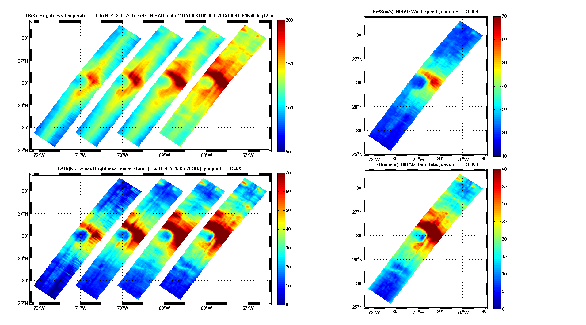
Tropical Cyclone Intensity (TCI) Hurricane Imaging Radiometer (HIRAD) V2.1
National Aeronautics and Space Administration —
The Tropical Cyclone Intensity (TCI) Hurricane Imaging Radiometer (HIRAD) dataset was created for the TCI field campaign from August 30, 2015 through October 23,... -
Federal
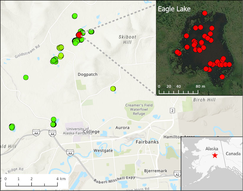
ABoVE: Methane Ebullition Hotspots in Frozen Lakes near Fairbanks, Alaska, Oct 2014
National Aeronautics and Space Administration —
This dataset includes maps of the locations and number of methane ebullition hotspots in 15 frozen lakes in the southern portion of the Goldstream Valley and the... -
Federal
AMSR-E/Aqua Weekly L3 Global Ascending/Descending .25x.25 deg Ocean Grids V002
National Aeronautics and Space Administration —
The Level-3 daily product (AE_DyOcn), weekly product (AE_WkOcn), and monthly product (AE_MoOcn) include SST, near-surface wind speed, columnar water vapor, and... -
Federal
OMI/Aura Surface UV Irradiance 1-orbit L2 Swath 13x24 km V003 (OMUVB) at GES DISC
National Aeronautics and Space Administration —
The Aura Ozone Monitoring Instrument (OMI) Version 003 Surface UV Irradiance Product (OMUVB) is now available from the NASA Goddard Earth Sciences Data and... -
Federal
ABoVE: Dall Sheep Lamb Recruitment and Climate Data, Alaska and NW Canada, 2000-2015 NGDA
National Aeronautics and Space Administration —
This dataset contains estimated annual average Dall sheep (Ovis dalli dalli) lamb-to-ewe ratios for each year from 2000-2015 across the full species range in Alaska... -
Federal
GPM Ground Validation Environment Canada (EC) Weather Station XET C3VP V1
National Aeronautics and Space Administration —
The GPM Ground Validation Environment Canada (EC) Weather Station XET C3VP dataset consists of surface meteorological data collected at the Environment Canada (EC)... -
Federal
REGIONAL AIR-SEA INTERACTION (RASI) GAP WIND AND COASTAL UPWELLING EVENTS CLIMATOLOGY GULF OF PANAMA, PANAMA V1
National Aeronautics and Space Administration —
The Regional Air-Sea Interactions (RASI) Gap Wind and Coastal Upwelling Events Climatology Gulf of Panama, Panama dataset was created using an automated intelligent... -
Federal
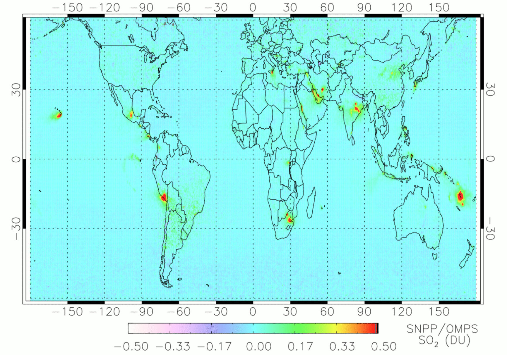
OMPS/NPP PCA SO2 Total Column 1-Orbit L2 Swath 50x50km V2 (OMPS_NPP_NMSO2_PCA_L2) at GES DISC
National Aeronautics and Space Administration —
The OMPS_NPP_NMSO2_PCA_L2 product is part of the MEaSUREs (Making Earth Science Data Records for Use in Research Environments) suite of products. It is retrieved from... -
Federal
Export and Leaching of Carbon and Nitrogen from Mississippi River Basin, 1901-2099
National Aeronautics and Space Administration —
This dataset provides estimates for export and leaching of dissolved inorganic carbon (DIC), dissolved organic carbon (DOC), total organic carbon (TOC), particulate... -
Federal
ABoVE: Wolf Denning Phenology and Reproductive Success, Alaska and Canada, 2000-2017 NGDA
National Aeronautics and Space Administration —
This dataset provides annual gray wolf (Canis lupus) denning spatial information and timing, associated climatic and phenologic metrics, and reproductive success... -
Federal
Soil Moisture Active Passive (SMAP) L1-L3 Ancillary GEOS Data V001
National Aeronautics and Space Administration —
This ancillary SMAP product contains three dynamic GMAO GEOS-5 modeled data sets. Each data set contains surface and atmospheric parameters pertinent to SMAP provided... -
Federal
SASSIE Arctic Field Campaign Shipboard Meteorology Data Fall 2022
National Aeronautics and Space Administration —
The Salinity and Stratification at the Sea Ice Edge (SASSIE) project is a NASA experiment that aims to understand how salinity anomalies in the upper ocean generated... -
Federal
MERRA-2 statM_2d_edi_Nx: 2d, Single-Level, Monthly Extremes Detection Indices based on 1991-2020 V2 (M2SMNXEDI) at GES DISC
National Aeronautics and Space Administration —
M2SMNXEDI (or statM_2d_edi_Nx) is a 2-dimensional monthly data collection for extreme detection indices derived from daily Modern-Era Retrospective analysis for... -
Federal
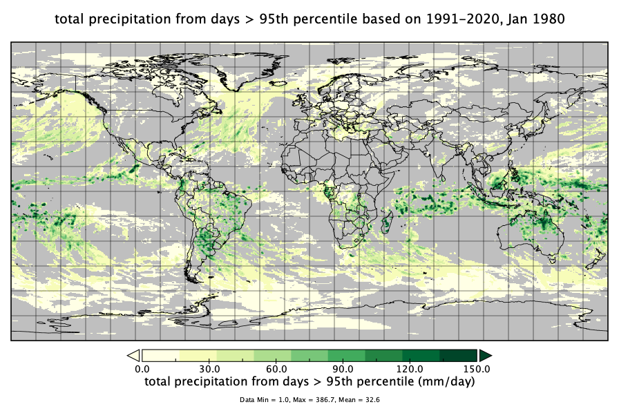
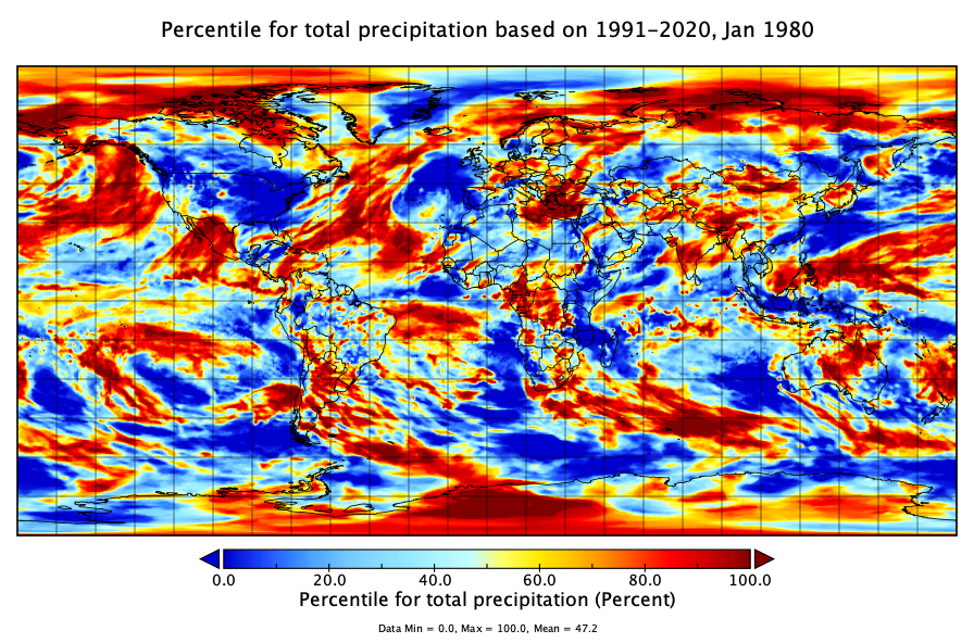
MERRA-2 statM_2d_pct_Nx: 2d, Single-Level, Monthly Percentiles based on 1991-2020 V2 (M2SMNXPCT) at GES DISC
National Aeronautics and Space Administration —
M2SMNXPCT (or statM_2d_pct_Nx) is a 2-dimensional monthly data collection for percentile statistics derived from monthly Modern-Era Retrospective analysis for... -
Federal
GPM GROUND VALIDATION OKLAHOMA CLIMATOLOGICAL SURVEY MESONET MC3E V1
National Aeronautics and Space Administration —
The GPM Ground Validation Oklahoma Climatological Survey Mesonet MC3E data were collected during the Midlatitude Continental Convective Clouds Experiment (MC3E) in... -
Federal
REGIONAL AIR-SEA INTERACTION (RASI) GAP WIND AND COASTAL UPWELLING EVENTS CLIMATOLOGY GULF OF PAPAGAYO, COSTA RICA V1
National Aeronautics and Space Administration —
The Regional Air-Sea Interactions (RASI) Gap Wind and Coastal Upwelling Events Climatology Gulf of Papagayo, Costa Rica dataset was created using an automated... -
Federal
GPM Ground Validation Snow Depth Monitoring System OLYMPEX V1
National Aeronautics and Space Administration —
The GPM Ground Validation Snow Depth Monitoring System OLYMPEX dataset consists of snow depth, temperature, and relative humidity measurements which were collected...

Official websites use .gov
A
.gov website belongs to an official government
organization in the United States.
Secure .gov websites use HTTPS
A
lock (
) or https:// means you’ve safely connected to
the .gov website. Share sensitive information only on official,
secure websites.