
-
Federal
Global Change Master Directory (GCMD)
National Aeronautics and Space Administration —
The GCMD database holds more than 30,000 descriptions of Earth science data sets and services covering all aspects of Earth and environmental sciences. The mission of... -
Federal
USGS Digital Orthophoto Quadrangles
National Aeronautics and Space Administration —
A Digital Orthophoto Quadrangle (DOQ) is a computer-generated image of an aerial photograph in which the image displacement caused by terrain relief and camera tilt... -
Federal
RADARSAT-1_LEVEL1
National Aeronautics and Space Administration —
RADARSAT-1 Level 1 Amplitude Images -
Federal
CLPX-Model: Land Data Assimilation System (LDAS) Data, Version 1
National Aeronautics and Space Administration —
The LDAS data set contains 43 model and observation-based fields produced by the LDAS uncoupled modeling system at the NASA Goddard Space Flight Center using the... -
Federal
SENTINEL-1B_SINGLE_POL_GRD_HIGH_RES
National Aeronautics and Space Administration —
Sentinel-1B Single-pol ground projected high and full resolution images -
Federal
LVIS Classic L2 Geolocated Surface Elevation and Canopy Height Product V001
National Aeronautics and Space Administration —
This data set contains Level-2 geolocated surface elevation and canopy height measurements collected by the NASA Land, Vegetation, and Ice Sensor (LVIS) Facility, an... -
Federal
Local Observations from the Seasonal Ice Zone Observing Network (SIZONet) and Alaska Arctic Observatory and Knowledge Hub (AAOKH), Version 2
National Aeronautics and Space Administration —
The Seasonal Ice Zone Observing Network (SIZONet) and the Alaska Arctic Observatory and Knowledge Hub (AAOKH) share the Local Observations Interface, which allows... -
Federal
Seasonal frost penetration, Sleepers River Research Watershed, Vermont, USA, Version 1
National Aeronautics and Space Administration —
The frost tube network is located within a 3.25-square-mile sub-watershed of the Sleepers River Research Watershed near Danville, Vermont, USA. Tubes were positioned... -
Federal
Upper soil temperatures in the Kolyma Highland, Version 1
National Aeronautics and Space Administration —
This data set contains soil temperature and meteorological data for various sampling locations near the Aborigen research station in the Kolyma Highland, Northeastern... -
Federal
SENTINEL-1B_DUAL_POL_GRD_MEDIUM_RES
National Aeronautics and Space Administration —
Sentinel-1B Dual-pol ground projected medium resolution images -
Federal
ERS-2_LEVEL0
National Aeronautics and Space Administration —
ERS-2 Standard Beam Data Level 0 -
Federal
CLPX-Satellite: MODIS Radiances, Reflectances, Snow Cover and Related Grids, Version 1 NGDA
National Aeronautics and Space Administration —
This data set provides Moderate Resolution Imaging Spectroradiometer (MODIS) data as part of the Cold Land Processes Field Experiment (CLPX). Parameters include... -
Federal
SENTINEL-1A_SINGLE_POL_GRD_MEDIUM_RES
National Aeronautics and Space Administration —
Sentinel-1A Single-pol ground projected medium resolution images -
Federal
SENTINEL-1B_DUAL_POL_GRD_HIGH_RES
National Aeronautics and Space Administration —
Sentinel-1B Dual-pol ground projected high and full resolution images -
Federal
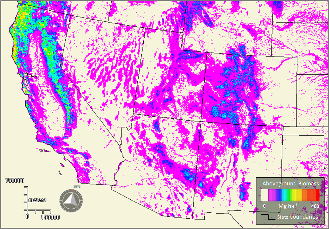
Forest Aboveground Biomass for the Southwestern U.S. from MISR, 2000-2021
National Aeronautics and Space Administration —
This dataset provides estimates of forest aboveground biomass (AGB; in Mg ha-1) at a resolution of 250 m for the southwestern United States over the time period... -
Federal
SENTINEL-1B_RAW
National Aeronautics and Space Administration —
Sentinel-1B level zero product -
Federal
SENTINEL-1B_METADATA_RAW
National Aeronautics and Space Administration —
Metadata for Sentinel-1B level zero product

Official websites use .gov
A
.gov website belongs to an official government
organization in the United States.
Secure .gov websites use HTTPS
A
lock (
) or https:// means you’ve safely connected to
the .gov website. Share sensitive information only on official,
secure websites.