
-
Federal
World Glacier Inventory, Version 1 14 recent views
National Aeronautics and Space Administration —
The World Glacier Inventory (WGI) contains information for over 130,000 glaciers, or about 85% of the total estimated number of glaciers. Inventory parameters include... -
Federal
USGS Digital Orthophoto Quadrangles
National Aeronautics and Space Administration —
A Digital Orthophoto Quadrangle (DOQ) is a computer-generated image of an aerial photograph in which the image displacement caused by terrain relief and camera tilt... -
Federal
RADARSAT-1_LEVEL1
National Aeronautics and Space Administration —
RADARSAT-1 Level 1 Amplitude Images -
Federal
CLPX-Model: Land Data Assimilation System (LDAS) Data, Version 1
National Aeronautics and Space Administration —
The LDAS data set contains 43 model and observation-based fields produced by the LDAS uncoupled modeling system at the NASA Goddard Space Flight Center using the... -
Federal
MERRA-2 tavgM_2d_glc_Nx: 2d,Monthly mean,Time-Averaged,Single-Level,Assimilation,Land Ice Surface Diagnostics 0.625 x 0.5 degree V5.12.4 (M2TMNXGLC) at GES DISC
National Aeronautics and Space Administration —
M2TMNXGLC (or tavgM_2d_glc_Nx) is a 2-dimensional monthly mean data collection in Modern-Era Retrospective analysis for Research and Applications version 2 (MERRA-2).... -
Federal
CLPX-Ground: ISA Snow Pit Measurements, Version 2
National Aeronautics and Space Administration —
This data set consists of snow pit data from nine study areas, within three larger-scale areas in northern Colorado (Fraser, North Park, and Rabbit Ears Meso-cell... -
Federal
GEWEX SRB Integrated Product (Rel-4) Ancillary 3-Hourly
National Aeronautics and Space Administration —
GEWEX SRB Integrated Product (Rel-4) Ancillary 3-Hourly contains the global fields of meteorology, clouds and other ancillary data that serves as the inputs to the... -
Federal
Sea Ice in the Belcher Islands, Nunavut, Canada, Version 1
National Aeronautics and Space Administration —
This data set contains interviews of three hunters from Sanikiliaq, Belcher Islands, in the territory of Nunavut, Canada. The hunters describe their observations of... -
Federal
AMSR-E/AMSR2 Unified L3 Global Daily 25 km EASE-Grid Snow Water Equivalent V001
National Aeronautics and Space Administration —
This AMSR-E/AMSR2 Unified Level-3 (L3) data set provides daily estimates of Snow Water Equivalent (SWE). SWE was derived from brightness temperature measurements... -
Federal
Snow Data Assimilation System (SNODAS) Data Products at NSIDC, Version 1
National Aeronautics and Space Administration —
This data set contains snow pack properties, such as depth and snow water equivalent (SWE), from the NOAA National Weather Service's National Operational Hydrologic... -
Federal
Continuous Records of Shallow Soil Temperature and Moisture in the Noatak River Basin, Alaska
Department of the Interior —
Soil moisture and temperature were measured at four shallow depths in multiple locations within tundra and forested landscapes of the Agashashok River basin. The... -
Federal
Descriptions, Depth to Refusal, and Field-Saturated Hydraulic Conductivity of Soils on the Arctic Coastal Plain of Alaska, 2012-2016
Department of the Interior —
This dataset includes soil data collected from various landscapes adjacent to thaw ponds on the North Slope of Alaska between 2012 and 2018. The landscapes include... -
Federal
MERRA-2 tavg1_2d_flx_Nx: 2d,1-Hourly,Time-Averaged,Single-Level,Assimilation,Surface Flux Diagnostics 0.625 x 0.5 degree V5.12.4 (M2T1NXFLX) at GES DISC
National Aeronautics and Space Administration —
M2T1NXFLX (or tavg1_2d_flx_Nx) is an hourly time-averaged 2-dimensional data collection in Modern-Era Retrospective analysis for Research and Applications version 2... -
Federal
SENTINEL-1B_SINGLE_POL_GRD_HIGH_RES
National Aeronautics and Space Administration —
Sentinel-1B Single-pol ground projected high and full resolution images -
Federal
Arctic Soil Freeze/Thaw Status from SMMR and SSM/I, Version 2
National Aeronautics and Space Administration —
This data set contains near-surface (< 5 cm) soil freeze/thaw status on snow-free and snow-covered land surfaces over the Arctic terrestrial drainage basin. The... -
Federal
Sea Ice Melt Pond Data from the Canadian Arctic, Version 1
National Aeronautics and Space Administration —
This data set contains observations of albedo, depth, and physical characteristics of melt ponds on sea ice, taken during the summer of 1994. The melt ponds studied... -
Federal
GEWEX SRB Integrated Product (Rel-4) Ancillary 3-Hourly Ocean-only
National Aeronautics and Space Administration —
GEWEXSRB_Rel4-IP_Ancillary_3hrly_oceanonly is the Global Energy and Water Exchanges (GEWEX) Surface Radiation Budget (SRB) Integrated Product (Rel-4) Ancillary... -
Federal
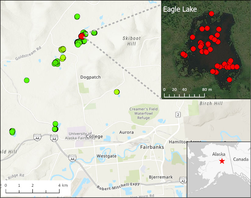
ABoVE: Methane Ebullition Hotspots in Frozen Lakes near Fairbanks, Alaska, Oct 2014
National Aeronautics and Space Administration —
This dataset includes maps of the locations and number of methane ebullition hotspots in 15 frozen lakes in the southern portion of the Goldstream Valley and the... -
Federal
MERRA-2 tavgU_2d_glc_Nx: 2d,diurnal,Time-Averaged,Single-Level,Assimilation,Land Ice Surface Diagnostics 0.625 x 0.5 degree V5.12.4 (M2TUNXGLC) at GES DISC
National Aeronautics and Space Administration —
M2TUNXGLC (or tavgU_2d_glc_Nx) is a 2-dimensional monthly diurnal means data collection in Modern-Era Retrospective analysis for Research and Applications version 2...

Official websites use .gov
A
.gov website belongs to an official government
organization in the United States.
Secure .gov websites use HTTPS
A
lock (
) or https:// means you’ve safely connected to
the .gov website. Share sensitive information only on official,
secure websites.