
-
Federal
RADARSAT-1_LEVEL1
National Aeronautics and Space Administration —
RADARSAT-1 Level 1 Amplitude Images -
Federal
CLPX-Model: Land Data Assimilation System (LDAS) Data, Version 1
National Aeronautics and Space Administration —
The LDAS data set contains 43 model and observation-based fields produced by the LDAS uncoupled modeling system at the NASA Goddard Space Flight Center using the... -
Federal
SENTINEL-1B_SINGLE_POL_GRD_HIGH_RES
National Aeronautics and Space Administration —
Sentinel-1B Single-pol ground projected high and full resolution images -
Federal
Seasonal frost penetration, Sleepers River Research Watershed, Vermont, USA, Version 1
National Aeronautics and Space Administration —
The frost tube network is located within a 3.25-square-mile sub-watershed of the Sleepers River Research Watershed near Danville, Vermont, USA. Tubes were positioned... -
Federal
Tundra Plant Reflectance, CO2 Exchange, PAM Fluorometry, and Pigments, AK, 2001-2002
National Aeronautics and Space Administration —
This dataset provides measurements at tundra plots collected near Utqiagvik and Atqasuk, AK, including visible-near infrared spectral reflectance, chamber gas... -
Federal
Upper soil temperatures in the Kolyma Highland, Version 1
National Aeronautics and Space Administration —
This data set contains soil temperature and meteorological data for various sampling locations near the Aborigen research station in the Kolyma Highland, Northeastern... -
Federal
Burned and Unburned Field Site Data, Noatak, Seward, and North Slope, AK, 2016-2018
National Aeronautics and Space Administration —
This dataset includes field measurements from unburned and burned 10 m x 10 m and 1 m x 1 m plots in the Noatak, Seward, and North Slope regions of the Alaskan tundra... -
Federal
SENTINEL-1B_DUAL_POL_GRD_MEDIUM_RES
National Aeronautics and Space Administration —
Sentinel-1B Dual-pol ground projected medium resolution images -
Federal
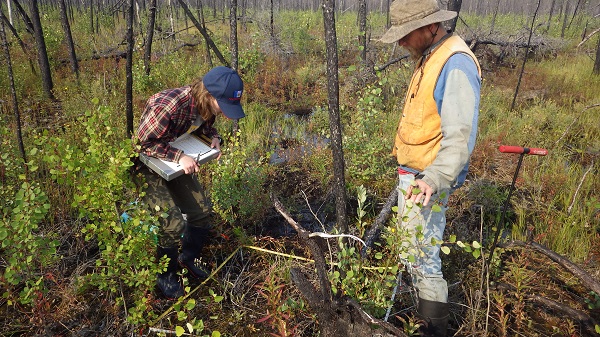
ABoVE: Post-Fire and Unburned Vegetation Community and Field Data, NWT, Canada, 2017
National Aeronautics and Space Administration —
This dataset provides vegetation community characteristics, soil moisture, and biophysical data collected in 2017 from 11 study sites in the ABoVE Study area. The 11... -
Federal
Arctic Vegetation Plots from Pingo Communities, North Slope, Alaska, 1984-1986
National Aeronautics and Space Administration —
This data set provides vegetation species and vegetation plot data collected between 1983 and 1985 from 293 study plots on 41 pingos on the North Slope of Alaska. The... -
Federal
Arctic Vegetation Plots Legacy Project Barter Island and Point Barrow, Alaska, 1994
National Aeronautics and Space Administration —
This dataset provides vegetation cover and environmental plot and soil data collected at two U.S. Air Force sites at Barter Island (BI) and Point Barrow (B), on the... -
Federal
ERS-2_LEVEL0
National Aeronautics and Space Administration —
ERS-2 Standard Beam Data Level 0 -
Federal
SENTINEL-1A_SINGLE_POL_GRD_MEDIUM_RES
National Aeronautics and Space Administration —
Sentinel-1A Single-pol ground projected medium resolution images -
Federal
SENTINEL-1B_DUAL_POL_GRD_HIGH_RES
National Aeronautics and Space Administration —
Sentinel-1B Dual-pol ground projected high and full resolution images -
Federal
ABoVE: Post-Fire and Unburned Vegetation Community and Field Data, NWT, Canada, 2019
National Aeronautics and Space Administration —
This dataset provides vegetation community characteristics, soil moisture, and biophysical data collected in 2019 from 11 study areas, which contained 28 sites that... -
Federal
SENTINEL-1B_RAW
National Aeronautics and Space Administration —
Sentinel-1B level zero product -
Federal
SENTINEL-1B_METADATA_RAW
National Aeronautics and Space Administration —
Metadata for Sentinel-1B level zero product

Official websites use .gov
A
.gov website belongs to an official government
organization in the United States.
Secure .gov websites use HTTPS
A
lock (
) or https:// means you’ve safely connected to
the .gov website. Share sensitive information only on official,
secure websites.