

9 datasets found
-
Federal
Soil Moisture Active Passive (SMAP) L1-L3 Ancillary GEOS Data V001
National Aeronautics and Space Administration —
This ancillary SMAP product contains three dynamic GMAO GEOS-5 modeled data sets. Each data set contains surface and atmospheric parameters pertinent to SMAP provided... -
Federal
SASSIE Arctic Field Campaign Shipboard Meteorology Data Fall 2022
National Aeronautics and Space Administration —
The Salinity and Stratification at the Sea Ice Edge (SASSIE) project is a NASA experiment that aims to understand how salinity anomalies in the upper ocean generated... -
Federal
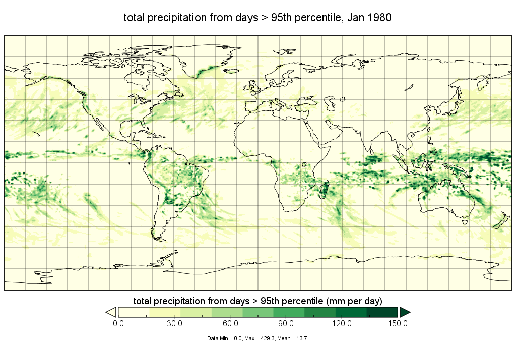
MERRA-2 statM_2d_edi_Nx: 2d, Single-Level, Monthly Extremes Detection Indices based on 1991-2020 V2 (M2SMNXEDI) at GES DISC
National Aeronautics and Space Administration —
M2SMNXEDI (or statM_2d_edi_Nx) is a 2-dimensional monthly data collection for extreme detection indices derived from daily Modern-Era Retrospective analysis for... -
Federal
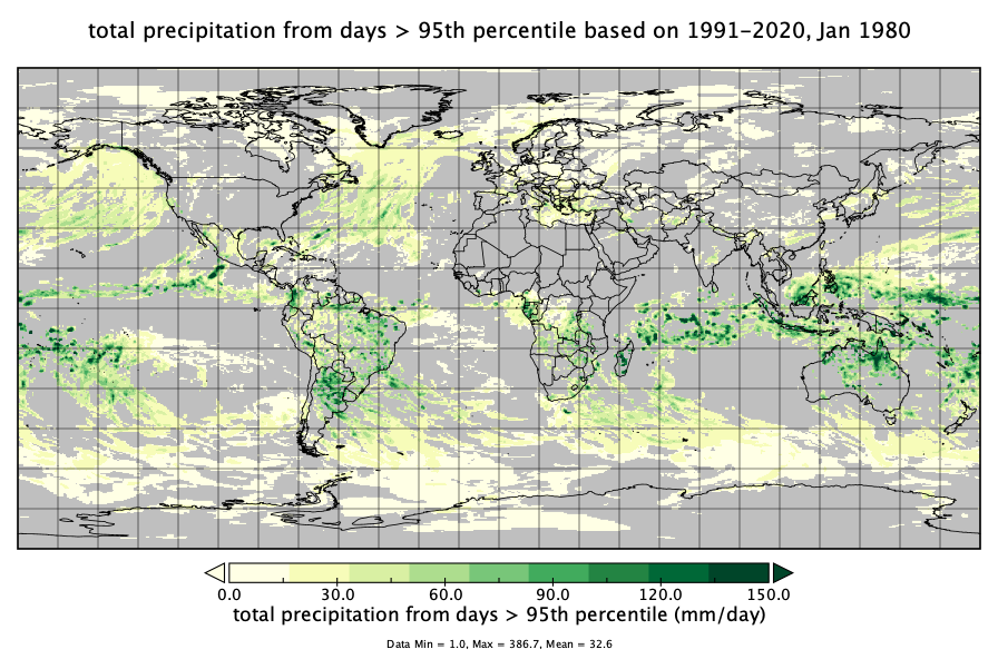
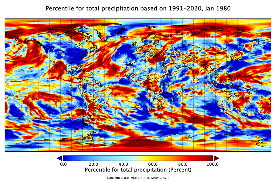
MERRA-2 statM_2d_pct_Nx: 2d, Single-Level, Monthly Percentiles based on 1991-2020 V2 (M2SMNXPCT) at GES DISC
National Aeronautics and Space Administration —
M2SMNXPCT (or statM_2d_pct_Nx) is a 2-dimensional monthly data collection for percentile statistics derived from monthly Modern-Era Retrospective analysis for... -
Federal
MERRA-2 statM_2d_edi_Nx: 2d, Single-Level, Monthly Extremes Detection Indices V1 (M2SMNXEDI) at GES DISC
National Aeronautics and Space Administration —
The Modern Era Retrospective analysis for Research and Applications, Version 2 (MERRA-2) contains a wealth of information that can be used for weather and climate... -
Federal
MERRA-2 statM_2d_pct_Nx: 2d, Single-Level, Monthly Percentiles V1 (M2SMNXPCT) at GES DISC
National Aeronautics and Space Administration —
The Modern Era Retrospective analysis for Research and Applications, Version 2 (MERRA-2) contains a wealth of information that can be used for weather and climate... -
Federal
ACCLIP WB-57 Aircraft Merge Data
National Aeronautics and Space Administration —
ACCLIP_Merge_WB57-Aircraft_Data is the pre-generated merge files created from a variety of in-situ instrumentation collecting measurements onboard the WB-57 aircraft... -
Federal
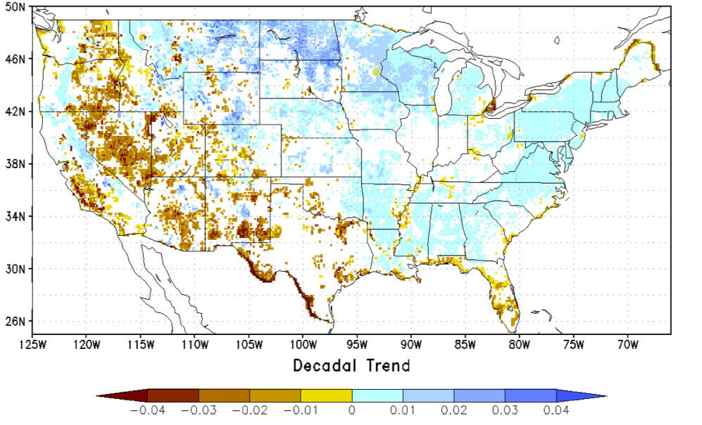
NCA-LDAS Noah-3.3 Land Surface Model L4 Trends 0.125 x 0.125 degree V2.0 (NCALDAS_NOAH0125_Trends) at GES DISC
National Aeronautics and Space Administration —
The National Climate Assessment - Land Data Assimilation System, or NCA-LDAS, is a terrestrial water reanalysis in support of the United States Global Change Research... -
Federal
Trends of Thermal, Wetness, and Vegetative Change in the Circumpolar Arctic
National Aeronautics and Space Administration —
This dataset provides estimates of trends in temperature, moisture, and vegetation changes over the circumpolar Arctic. Time series trends were measured by the Theil-...
9 datasets found