
-
Federal
GOES-R PLT Kennedy Space Center Lightning Mapping Array (LMA) V1
National Aeronautics and Space Administration —
The GOES-R PLT Kennedy Space Center Lightning Mapping Array (LMA) dataset consists of total lightning data measured from the Kennedy Space Center LMA (KSCLMA) network... -
Federal
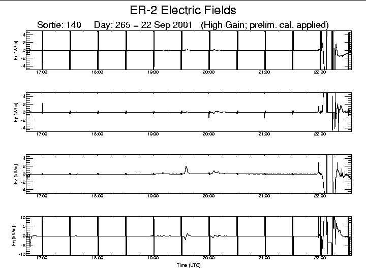
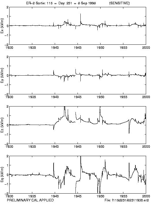
CAMEX-4 ER-2 LIGHTNING INSTRUMENT PACKAGE (LIP) V1
National Aeronautics and Space Administration —
The CAMEX-4 ER-2 Lightning Instrument Package (LIP) dataset was collected by the ER-2 LIP, which allows the vector components of the electric field (i.e, Ex, Ey, Ez )... -
Federal
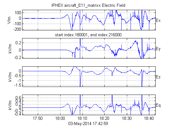
GPM Ground Validation Lightning Instrument Package (LIP) IPHEx V1
National Aeronautics and Space Administration —
The GPM Ground Validation Lightning Instrument Package (LIP) IPHEx dataset consists of electrical field measurements of lightning and navigation data collected by the... -
Federal
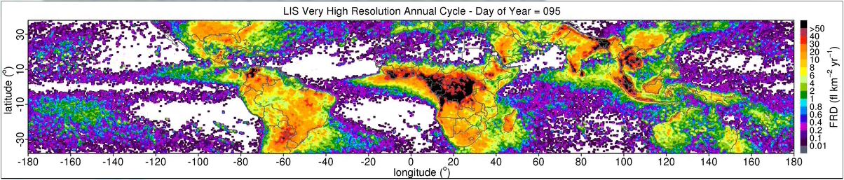
LIS 0.1 DEGREE VERY HIGH RESOLUTION GRIDDED LIGHTNING FULL CLIMATOLOGY (VHRFC) V1
National Aeronautics and Space Administration —
The LIS 0.1 Degree Very High Resolution Gridded Lightning Full Climatology (VHRFC) dataset consists of gridded full climatologies of total lightning flash rates seen... -
Federal
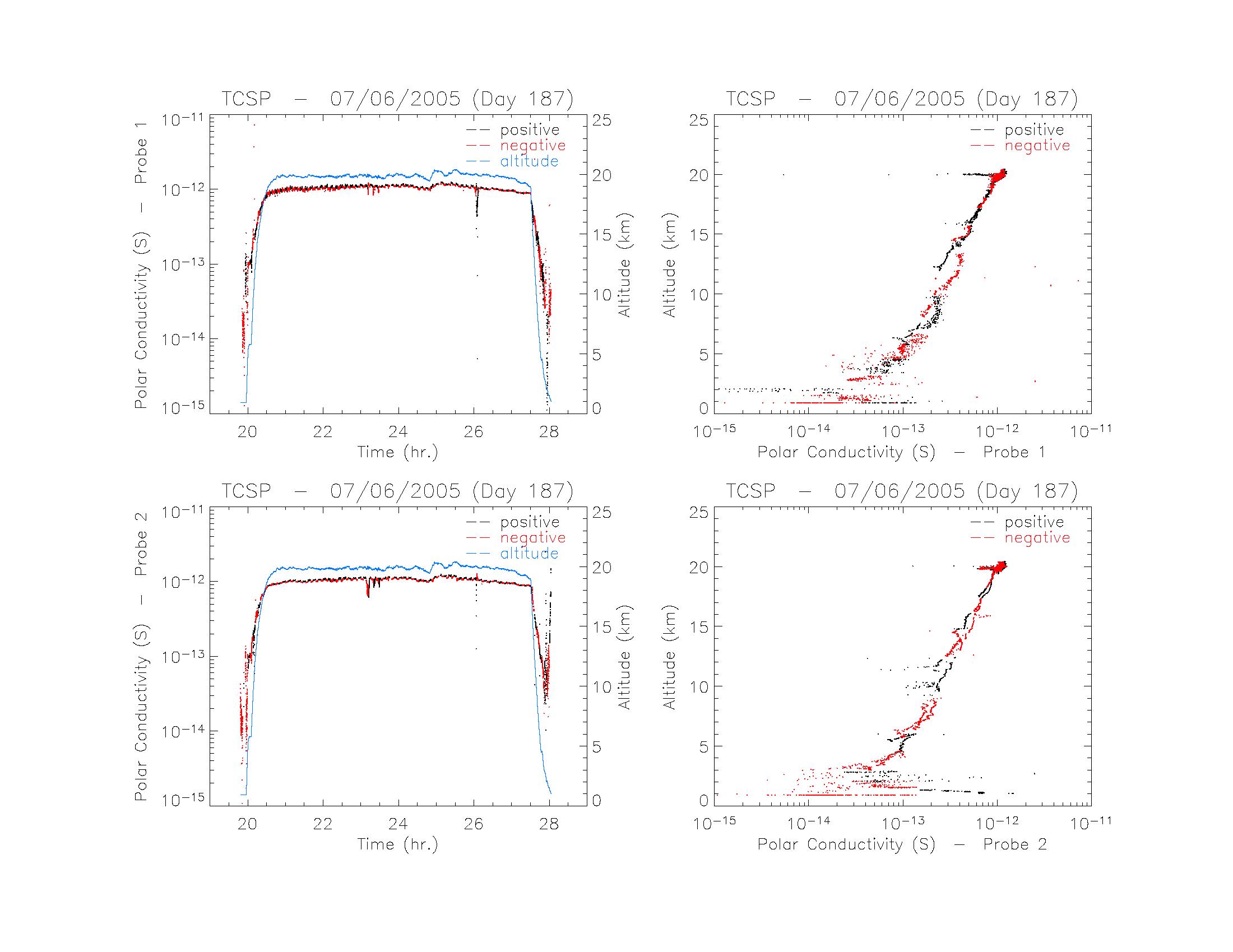
TCSP ER-2 LIGHTNING INSTRUMENT PACKAGE (LIP) V1
National Aeronautics and Space Administration —
The TCSP ER-2 Lightning Instrument Package (LIP) dataset consists of electrical field measurements of lightning from seven field mills, air conductivity data from a... -
Federal
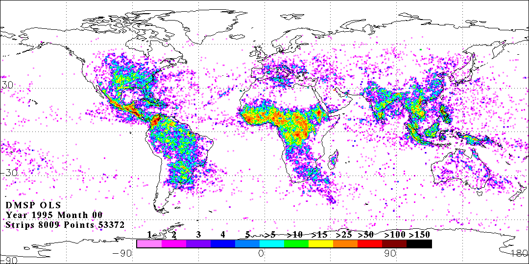
OLS DIGITAL DERIVED LIGHTNING FROM DMSP F12 V1
National Aeronautics and Space Administration —
The OLS Digital Derived Lightning from DMSP F12 dataset consists of global lightning signatures from the Defense Meteorological Satellite Program (DMSP) Operational... -
Federal
GOES-R PLT West Texas Lightning Mapping Array (LMA) V1
National Aeronautics and Space Administration —
The GOES-R PLT West Texas Lightning Mapping Array (LMA) dataset consists of total lightning data measured from the West Texas LMA (WTXLMA) network during the GOES-R... -
Federal
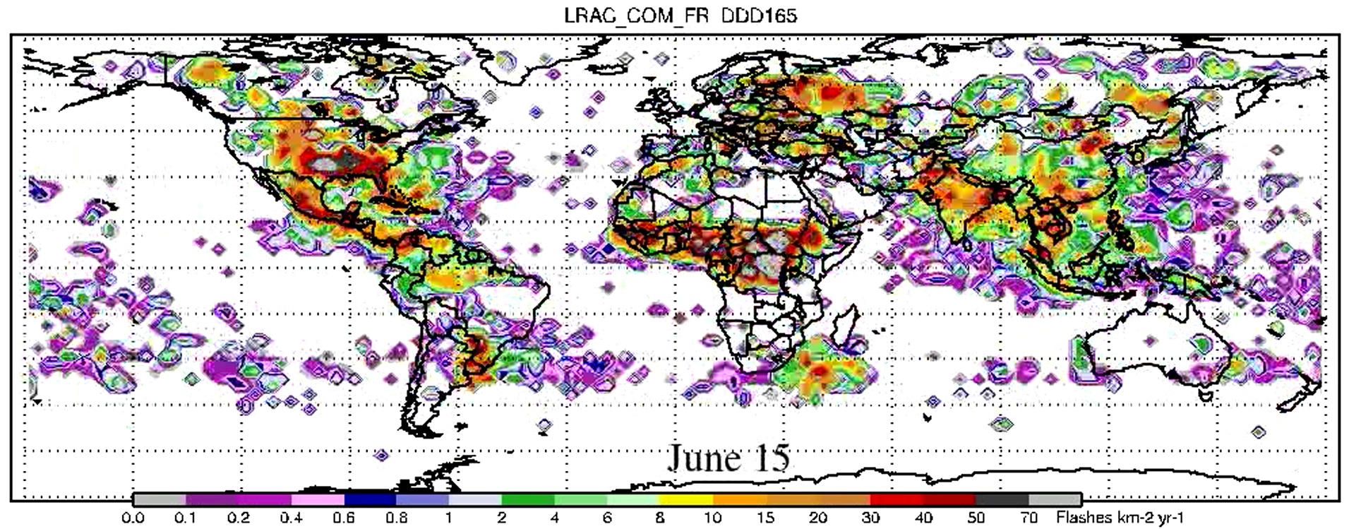
LIS/OTD 2.5 Degree Low Resolution Annual Climatology (LRAC) V2.3.2015
National Aeronautics and Space Administration —
The LIS/OTD 2.5 Degree Low Resolution Annual Climatology (LRAC) contains a variety of gridded climatologies of total lightning flash rates obtained from two lightning... -
Federal
LIS/OTD 0.5 Degree High Resolution Monthly Climatology (HRMC) V2.3.2015
National Aeronautics and Space Administration —
The LIS/OTD 0.5 Degree High Resolution Monthly Climatology (HRMC) contains a variety of gridded climatologies of total lightning flash rates obtained from two... -
Federal
LIS 0.1 DEGREE VERY HIGH RESOLUTION GRIDDED LIGHTNING ANNUAL CLIMATOLOGY (VHRAC) V1
National Aeronautics and Space Administration —
The LIS 0.1 Degree Very High Resolution Gridded Lightning Annual Climatology (VHRAC) dataset consists of gridded annual climatologies of total lightning flash rates... -
Federal
GOES-R PLT Washington D.C. Lightning Mapping Array (LMA) V1
National Aeronautics and Space Administration —
The GOES-R PLT Washington D.C. Lightning Mapping Array (LMA) dataset consists of total lightning data measured from the Washington D.C. LMA (DCLMA) network during the... -
Federal
Lightning Imaging Sensor (LIS) on TRMM Backgrounds V4
National Aeronautics and Space Administration —
The Lightning Imaging Sensor (LIS) Backgrounds was collected by the LIS instrument on the Tropical Rainfall Measuring Mission (TRMM) satellite used to detect the... -
Federal
CAMEX-3 LIGHTNING INSTRUMENT PACKAGE (LIP) V1
National Aeronautics and Space Administration —
The CAMEX-3 Lightning Instrument Package (LIP) dataset contains electrical field measurements of lightning within storms studied during the Convection And Moisture... -
Federal
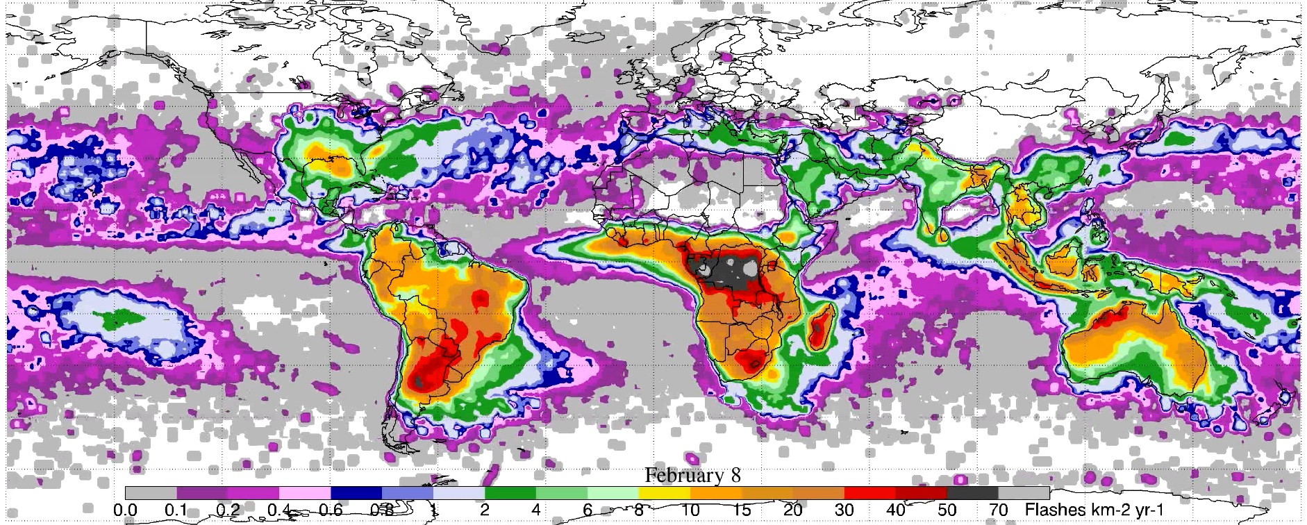
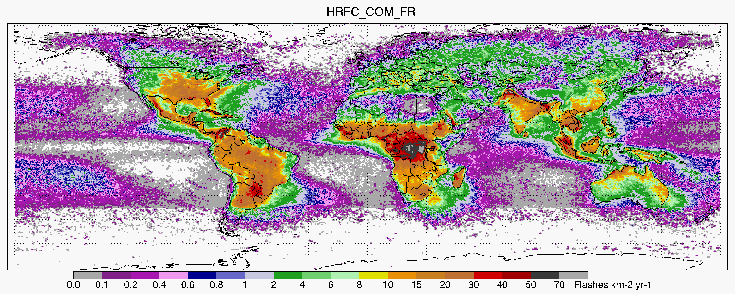
LIS/OTD 0.5 Degree High Resolution Full Climatology (HRFC) V2.3.2015
National Aeronautics and Space Administration —
The LIS/OTD 0.5 Degree High Resolution Full Climatology (HRFC) contains a variety of gridded climatologies of total lightning flash rates obtained from two lightning... -
Federal
GOES-R PLT Southern Ontario Lightning Mapping Array (LMA) V1
National Aeronautics and Space Administration —
The GOES-R PLT Southern Ontario Lightning Mapping Array (LMA) dataset consists of total lightning data measured from the Southern Ontario LMA (SOLMA) network during... -
Federal
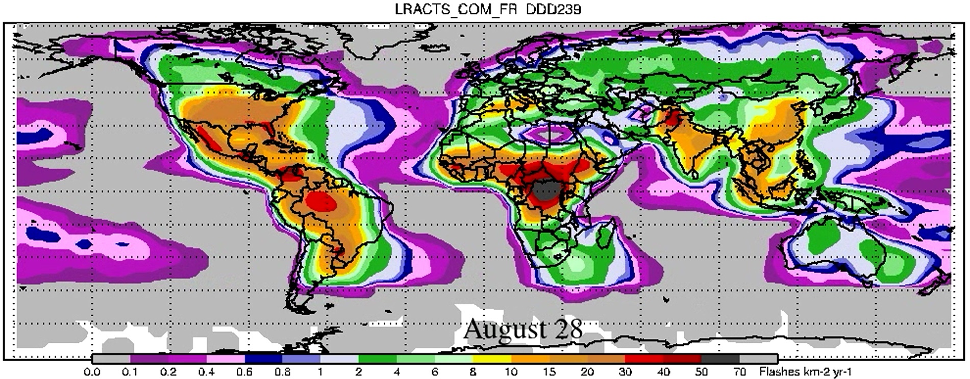
LIS/OTD 2.5 Degree Low Resolution Annual Climatology Time Series (LRACTS) V2.3.2015
National Aeronautics and Space Administration —
The LIS/OTD 2.5 Degree Low Resolution Annual Climatology Time Series (LRACTS) consists of gridded climatologies of total lightning flash rates seen by the spaceborne...

Official websites use .gov
A
.gov website belongs to an official government
organization in the United States.
Secure .gov websites use HTTPS
A
lock (
) or https:// means you’ve safely connected to
the .gov website. Share sensitive information only on official,
secure websites.