
-
Federal
Channel Islands, Kelp Forest Monitoring, Sea Temperature, 1993-2007
National Oceanic and Atmospheric Administration, Department of Commerce —
This dataset from the Channel Islands National Park's Kelp Forest Monitoring Program has subtidal temperature data taken at permanent monitoring sites. Since 1993,... -
Federal
Newport Lab CTD Casts, 1997-2008
National Oceanic and Atmospheric Administration, Department of Commerce —
The Newport Hydrographic (NH) Line along 44.65°N off central Oregon was sampled seasonally during two epochs: 1961-1971 through the TENOC program and 1997-2003... -
Federal
Net Radiation and Albedo from MODIS for Xingu River Basin, Brazil, 2000-2012 NGDA
National Aeronautics and Space Administration —
This dataset provides daily average land surface net radiation (Rnet) as an 8-day time series at approximately 0.5 km resolution for the upper Xingu River Basin in... -
Federal
Local Observations from the Seasonal Ice Zone Observing Network (SIZONet) and Alaska Arctic Observatory and Knowledge Hub (AAOKH), Version 2
National Aeronautics and Space Administration —
The Seasonal Ice Zone Observing Network (SIZONet) and the Alaska Arctic Observatory and Knowledge Hub (AAOKH) share the Local Observations Interface, which allows... -
Federal
Global Forest Ecosystem Structure and Function Data For Carbon Balance Research
National Aeronautics and Space Administration —
A comprehensive global database has been assembled to quantify CO2 fluxes and pathways across different levels of integration (from photosynthesis up to net ecosystem... -
Federal
Channel Islands, Kelp Forest Monitoring, Size and Frequency, Natural Habitat, 1985-2007
National Oceanic and Atmospheric Administration, Department of Commerce —
This dataset has measurements of the size of selected animal species at selected locations in the Channel Islands National Park. Sampling is conducted annually... -
Federal
Tundra Plant Reflectance, CO2 Exchange, PAM Fluorometry, and Pigments, AK, 2001-2002
National Aeronautics and Space Administration —
This dataset provides measurements at tundra plots collected near Utqiagvik and Atqasuk, AK, including visible-near infrared spectral reflectance, chamber gas... -
Federal
Global-Gridded Daily Methane Emissions from Inland Dam-Reservoir Systems
National Aeronautics and Space Administration —
This dataset includes global maps of methane (CH4) emissions from inland dam-reservoir systems at 0.25-degree spatial resolution. Daily emission rates (as grams of... -
Federal
Burned and Unburned Field Site Data, Noatak, Seward, and North Slope, AK, 2016-2018
National Aeronautics and Space Administration —
This dataset includes field measurements from unburned and burned 10 m x 10 m and 1 m x 1 m plots in the Noatak, Seward, and North Slope regions of the Alaskan tundra... -
Federal
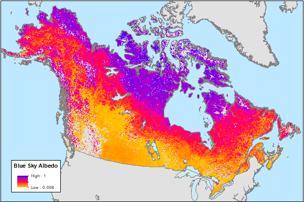
ABoVE: MODIS-Derived Daily Mean Blue Sky Albedo for Northern North America, 2000-2017 NGDA
National Aeronautics and Space Administration —
This dataset contains MODIS-derived daily mean shortwave blue sky albedo for northern North America (i.e., Canada and Alaska) and a set of quality control flags for... -
Federal
ABoVE: Synthesis of Burned and Unburned Forest Site Data, AK and Canada, 1983-2016
National Aeronautics and Space Administration —
This dataset is a synthesis of field plot characterization data, derived above-ground and below-ground combusted carbon, and acquired Fire Weather Index (FWI) System... -
Federal
Channel Islands, Kelp Forest Monitoring, Survey, 1m Quadrat, 1982-2007
National Oceanic and Atmospheric Administration, Department of Commerce —
This dataset from the Channel Islands National Park's Kelp Forest Monitoring Program has measurements of the abundance (density) of relatively abundant selected... -
Federal
ABoVE: Burned Area, Depth, and Combustion for Alaska and Canada, 2001-2019 NGDA
National Aeronautics and Space Administration —
This dataset provides annual gridded estimates of fire locations and associated burn fraction per pixel for Alaska and Canada at approximately 500 m spatial... -
Federal
Channel Islands, Kelp Forest Monitoring, Survey, Random Point Contact, 1982-2007
National Oceanic and Atmospheric Administration, Department of Commerce —
This dataset from the Channel Islands National Park's Kelp Forest Monitoring Program has estimates of substrate composition and percent cover of selected algal and... -
Federal
Channel Islands, Kelp Forest Monitoring, Survey, Fish Transect, 1985-2007
National Oceanic and Atmospheric Administration, Department of Commerce —
This dataset from the Channel Islands National Park's Kelp Forest Monitoring Program has measurements of the abundance of fish species. The original measurements were... -
Federal
Pre-Delta-X: Spectral Reflectance of Water Surface, Atchafalaya Basin, LA, USA, 2016
National Aeronautics and Space Administration —
This dataset provides measurements of in situ remote-sensing reflectance (Rrs; per steradian) of surface water across Atchafalaya Basin, southern coastal Louisiana,... -
Federal
C-HARM v1, 3-Day Forecast, Pseudo-nitzschia, cellular domoic acid, and particular domoic acid probability, California and Southern Oregon coast, 2018-2022
National Oceanic and Atmospheric Administration, Department of Commerce —
The C-HARM model generates nowcast and forecasts of the probability of Pseudo-nitzschia concentrations of in excess of 10,000 cells/L in California and Southern... -
Federal
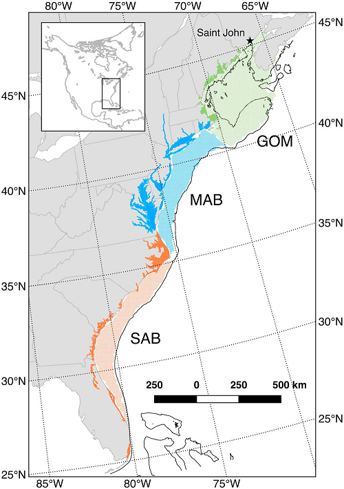
Mean Annual Fluxes of Carbon in Coastal Ecosystems of Eastern North America
National Aeronautics and Space Administration —
This dataset contains best estimates and uncertainties for mean annual fluxes of inorganic, organic, and total (organic + inorganic) carbon in tidal wetlands,... -
Federal
Coordinated Eastern Arctic Experiment (CEAREX) Data, Version 1
National Aeronautics and Space Administration —
CEAREX was a multi-platform field program conducted in the Norwegian Seas and Greenland north to Svalbard from September 1988 through May 1989. Canada, Denmark,... -
Federal
C-HARM v2 3-Day Forecast, Pseudo-nitzschia, cellular domoic acid, and particular domoic acid probability, California and Southern Oregon coast, 2022-present
National Oceanic and Atmospheric Administration, Department of Commerce —
The C-HARM model generates nowcast and forecasts of the probability of Pseudo-nitzschia concentrations of in excess of 10,000 cells/L, the probability of particulate...

Official websites use .gov
A
.gov website belongs to an official government
organization in the United States.
Secure .gov websites use HTTPS
A
lock (
) or https:// means you’ve safely connected to
the .gov website. Share sensitive information only on official,
secure websites.