
-
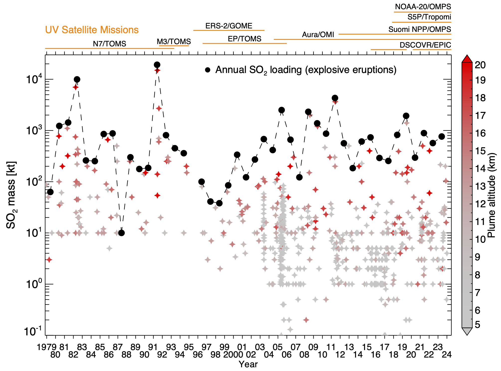
Federal
Multi-Satellite Air Quality Sulfur Dioxide (SO2) Database Long-Term L4 Global V2 (MSAQSO2L4) at GES DISC
National Aeronautics and Space Administration —
These data are a part of Multi-Decadal Sulfur Dioxide (SO2) Climatology from Satellite Instruments (MEaSUREs-12-0022 project). Version 2 of the global catalogue of... -
Federal
Global 15 x 15 Minute Grids of the Downscaled Population Based on the SRES B2 Scenario, 1990 and 2025
National Aeronautics and Space Administration —
The Global 15x15 Minute Grids of the Downscaled Population Based on the Special Report on Emissions Scenarios (SRES) B2 Scenario, 1990 and 2025, are geospatial... -
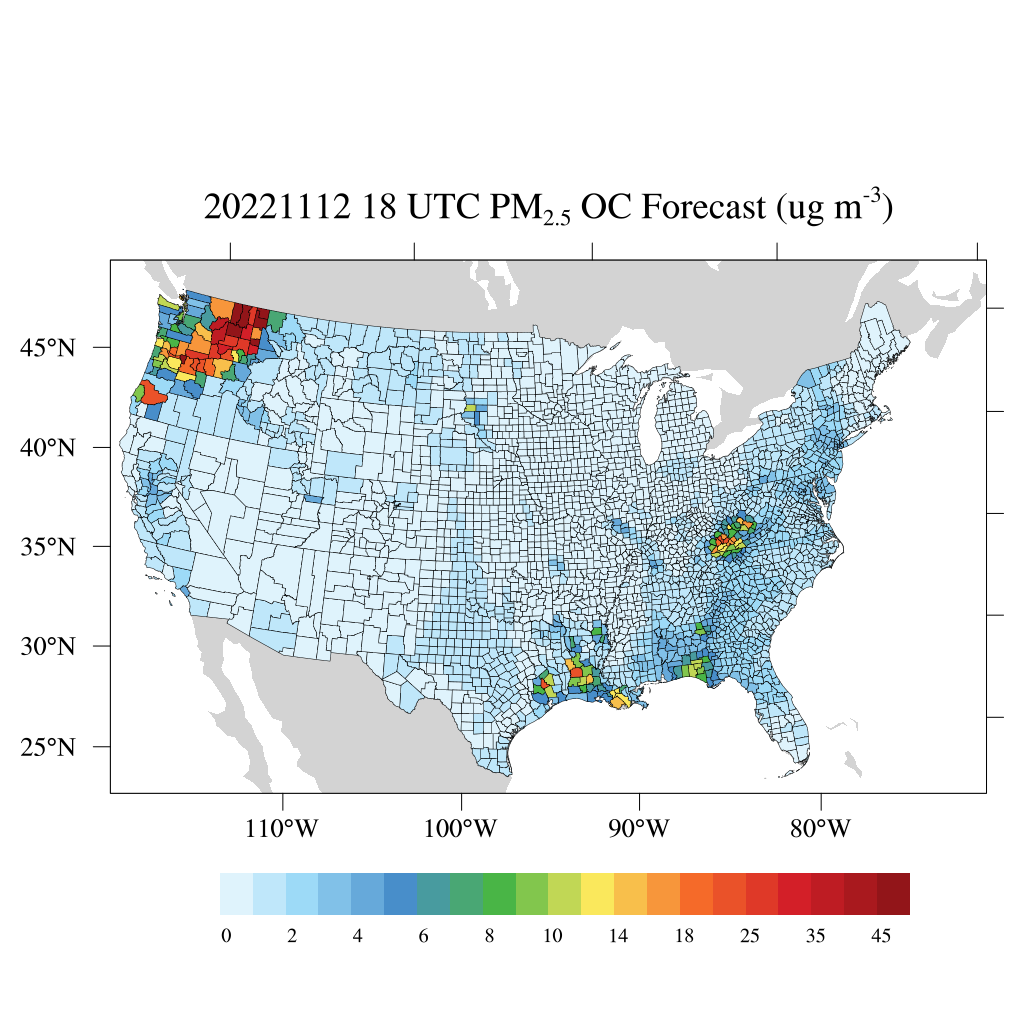
Federal
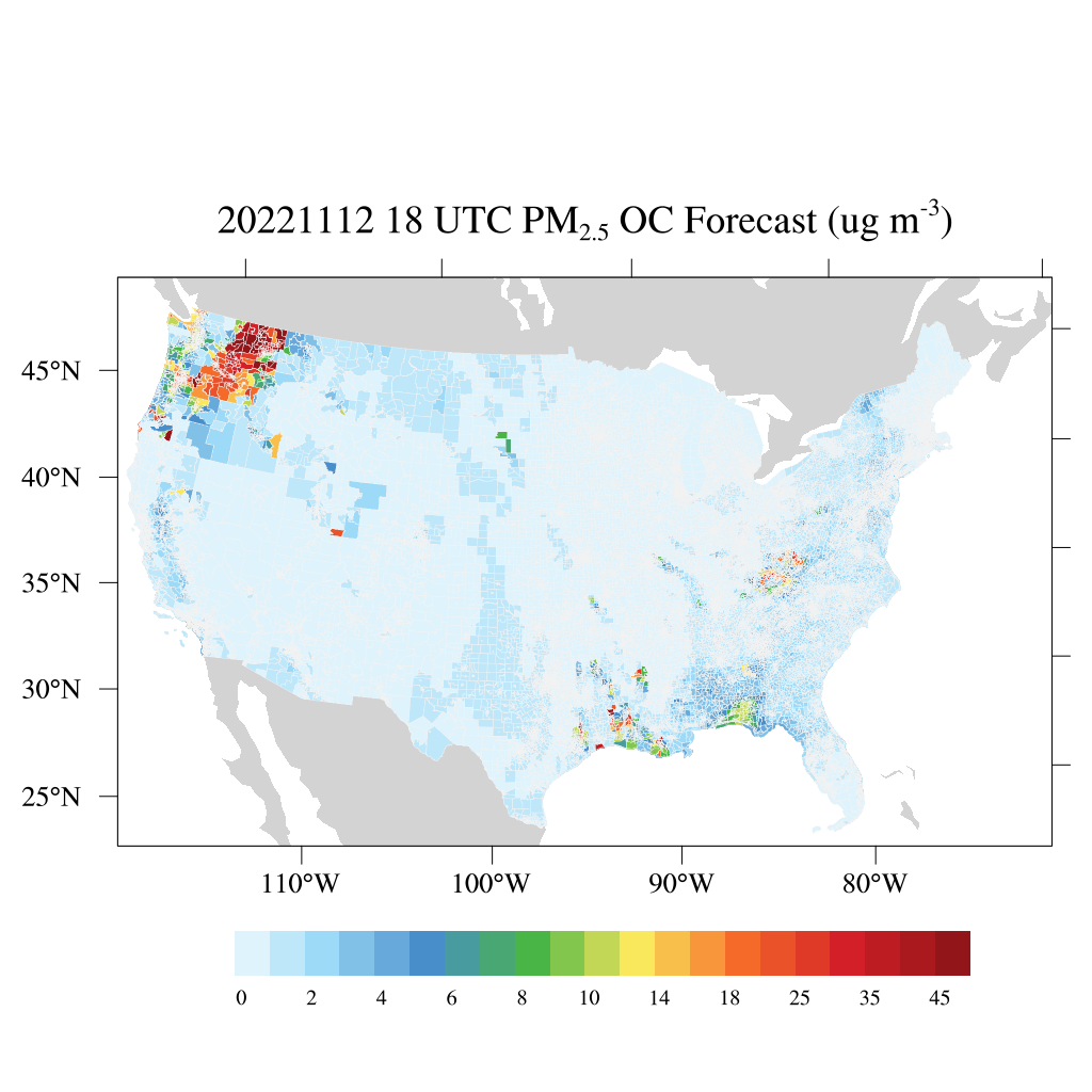
HAQES 3-Hourly Ensemble mean surface PM2.5 Organic Carbon concentration at census level, North America V1 (HAQES_NA_PM25_OC_CENSUS) at GES DISC
National Aeronautics and Space Administration —
This product provides HAQES 3-hourly ensemble mean surface PM2.5 Organic Carbon concentration at the census level over the continental United States (CONUS). The... -
Federal
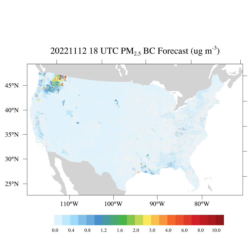
HAQES 3-Hourly Ensemble mean surface PM2.5 Black Carbon concentration at census level, North America V1 (HAQES_NA_PM25_BC_CENSUS) at GES DISC
National Aeronautics and Space Administration —
This product provides HAQES 3-hourly ensemble mean surface PM2.5 Black Carbon concentration at the census level over the continental United States (CONUS). The... -
Federal
MERRA-2 avgM_2d_pm25_admin0, 2d, Single-Level, Country-Level Surface PM2.5 Monthly Mean Products V1 (M2_TMAX_PM25) at GES DISC
National Aeronautics and Space Administration —
M2_TMAX_PM25 is a value-added product derived from the MERRA-2 aerosol monthly product M2TMNXAER_5.12.4 (or tavgM_2d_aer_Nx). The surface concentration of fine... -
Federal
Vulcan: High-Resolution Annual Fossil Fuel CO2 Emissions in USA, 2010-2015, Version 3
National Aeronautics and Space Administration —
The Vulcan version 3.0 annual dataset provides estimates of annual carbon dioxide (CO2) emissions from the combustion of fossil fuels (FF) and CO2 emissions from... -
Federal
OMPS/NPP PCA SO2 Total Column 1-Orbit L2 Swath 50x50km V2 (OMPS_NPP_NMSO2_PCA_L2) at GES DISC
National Aeronautics and Space Administration —
The OMPS_NPP_NMSO2_PCA_L2 product is part of the MEaSUREs (Making Earth Science Data Records for Use in Research Environments) suite of products. It is retrieved from... -
Federal
Export and Leaching of Carbon and Nitrogen from Mississippi River Basin, 1901-2099
National Aeronautics and Space Administration —
This dataset provides estimates for export and leaching of dissolved inorganic carbon (DIC), dissolved organic carbon (DOC), total organic carbon (TOC), particulate... -
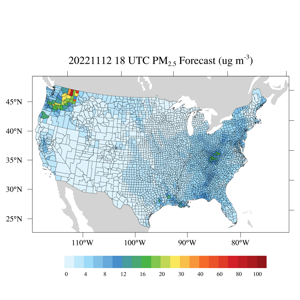
Federal
HAQES 3-Hourly Ensemble mean surface total PM2.5 concentration at census level, North America V1 (HAQES_NA_PM25_TOT_CENSUS) at GES DISC
National Aeronautics and Space Administration —
This product provides HAQES 3-hourly ensemble mean surface total PM2.5 concentration at the census level over the continental United States (CONUS). The Hazardous Air... -
Federal
HAQES 3-Hourly Ensemble mean surface total PM2.5 concentration at county level, North America V1 (HAQES_NA_PM25_TOT_COUNTY) at GES DISC
National Aeronautics and Space Administration —
This product provides HAQES 3-hourly ensemble mean surface total PM2.5 concentration at the county level over the continental United States (CONUS). The Hazardous Air... -
Federal
HAQES 3-Hourly Ensemble mean surface PM2.5 Organic Carbon concentration at county level, North America V1 (HAQES_NA_PM25_OC_COUNTY) at GES DISC
National Aeronautics and Space Administration —
This product provides HAQES 3-hourly ensemble mean surface PM2.5 Organic Carbon concentration at the county level over the continental United States (CONUS). The... -
Federal
Annual Summary of Artificial Light At Night from VIIRS/S-NPP at CONUS County and Census Tract V1 (ALAN_VIIRS_CONUS) at GES DISC
National Aeronautics and Space Administration —
This product provides detailed information about the satellite-based data on artificial light at night (ALAN). The Suomi National Polar-orbiting Partnership (S-NPP)... -
Federal
ABoVE: Burned Area, Depth, and Combustion for Alaska and Canada, 2001-2019 NGDA
National Aeronautics and Space Administration —
This dataset provides annual gridded estimates of fire locations and associated burn fraction per pixel for Alaska and Canada at approximately 500 m spatial... -
Federal
ATom: Merged Atmospheric Chemistry, Trace Gases, and Aerosols, Version 2
National Aeronautics and Space Administration —
This dataset provides information on greenhouse gases and human-produced air pollution, including atmospheric concentrations of carbon dioxide (CO2), methane (CH4),... -
Federal
CARVE: Alaskan Fire Emissions Database (AKFED), 2001-2013 NGDA
National Aeronautics and Space Administration —
This data set provides estimates of annual carbon emissions (kg carbon per square meter) from boreal fires at 450-m resolution for the state of Alaska between 2001... -
Federal
TOMS/N7 MS SO2 Vertical Column 1-Orbit L2 Swath 50x50 km V3 (TOMSN7SO2) at GES DISC
National Aeronautics and Space Administration —
Version 3 is the current version of the data set. Older versions will no longer be available and have been superseded by Version 3. The goal of this data set is to... -
Federal
Multi-Satellite Volcanic Sulfur Dioxide L4 Long-Term Global Database V4 (MSVOLSO2L4) at GES DISC
National Aeronautics and Space Administration —
Version 4 is the current version of the data set. Older versions are no longer available and have been superseded by Version 4. These data are a part of MEaSUREs 2012... -
Federal
Geoecology: County-Level Environmental Data for the United States, 1941-1981
National Aeronautics and Space Administration —
The Geoecology database is a compilation of environmental data for the period 1941 to 1981. The Geoecology database contains selected data on terrain and soils, water... -
Federal
NACP North American 8-km Net Ecosystem Exchange and Component Fluxes, 2004
National Aeronautics and Space Administration —
This data set provides modeled carbon flux estimates at 8-km spatial resolution over North America for the year 2004 of (1) net ecosystem exchange (NEE) of carbon... -
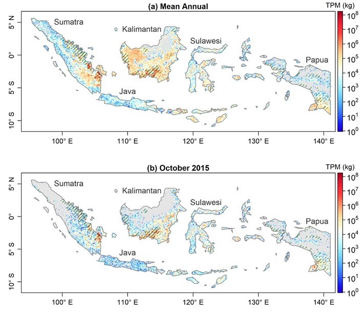
Federal
Fire Particulate Emissions from Combined VIIRS and AHI Data for Indonesia, 2015-2020
National Aeronautics and Space Administration —
This dataset provides 10-minute fire emissions within 0.1-degree regularly spaced intervals across Indonesia from July 2015 to December 2020. The dataset was produced...

Official websites use .gov
A
.gov website belongs to an official government
organization in the United States.
Secure .gov websites use HTTPS
A
lock (
) or https:// means you’ve safely connected to
the .gov website. Share sensitive information only on official,
secure websites.