
-
Federal
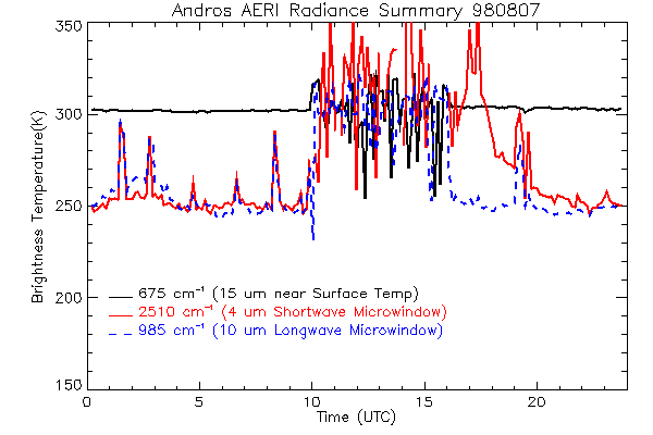
CAMEX-3 ATMOSPHERIC EMITTED RADIANCE INTERFEROMETER (AERI) V1
National Aeronautics and Space Administration —
The Atmospheric Emitted Radiance Interferometer (AERI) was used to make atmospheric temperature and moisture retrievals. AERI provides absolutely calibrated radiances... -
Federal
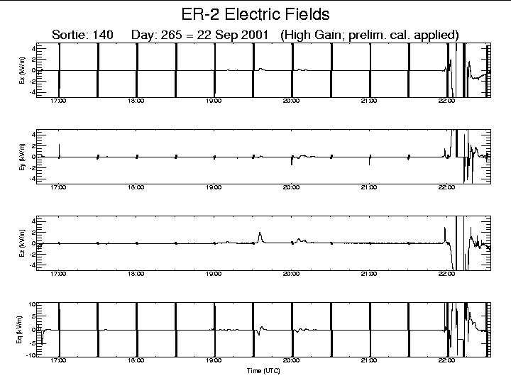
CAMEX-4 ER-2 LIGHTNING INSTRUMENT PACKAGE (LIP) V1
National Aeronautics and Space Administration —
The CAMEX-4 ER-2 Lightning Instrument Package (LIP) dataset was collected by the ER-2 LIP, which allows the vector components of the electric field (i.e, Ex, Ey, Ez )... -
Federal
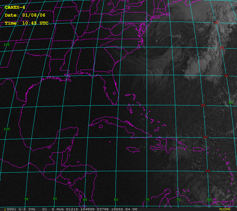
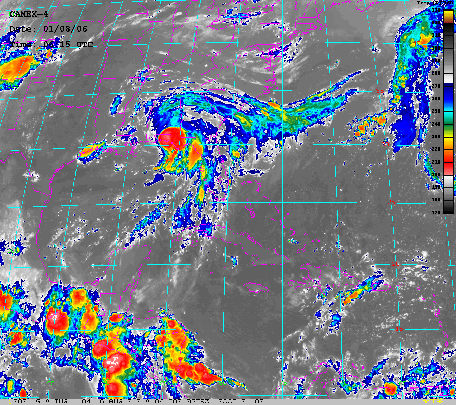
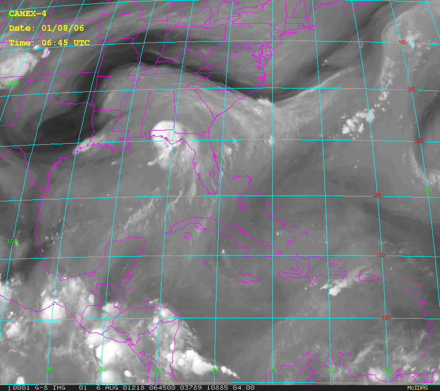
CAMEX-4 GOES-8 PRODUCTS V1
National Aeronautics and Space Administration —
The CAMEX-4 GOES-8 Products dataset was collected during the CAMEX-4 field campaign, which ocused on the study of tropical cyclone (hurricane) development, tracking,... -
Federal
AIRS/Aqua L3 Monthly Quantization in Physical Units (AIRS+AMSU+HSB) 5 degrees x 5 degrees V006 (AIRH3QPM) at GES DISC
National Aeronautics and Space Administration —
The Atmospheric Infrared Sounder (AIRS) is a grating spectrometer (R = 1200) aboard the second Earth Observing System (EOS) polar-orbiting platform, EOS Aqua. In... -
Federal
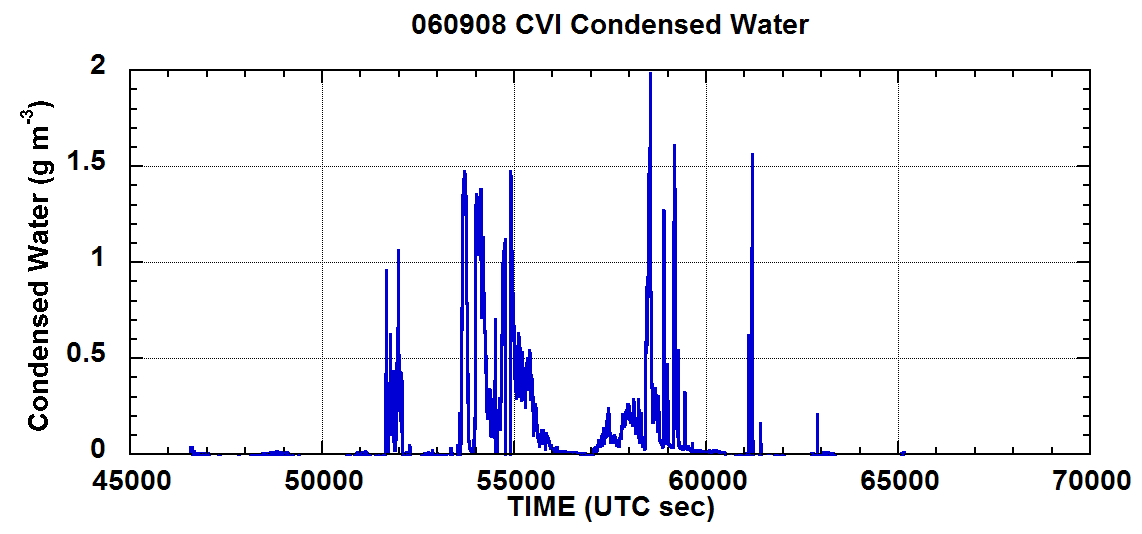
NAMMA CVI CLOUD CONDENSED WATER CONTENT V1
National Aeronautics and Space Administration —
In the NAMMA CVI Cloud Condensed Water Content dataset the counterflow virtual impactor (CVI) was used to measure condensed water content (liquid water or ice in... -
Federal
CAMEX-3 CLOUD AND AEROSOL PARTICLE CHARACTERIZATION (CAPAC) V1
National Aeronautics and Space Administration —
CAPAC is a series of three instruments: the Forward Scattering Spectrometer Probe model 300 (FSSP-300), the Two Dimensional Optical Array Probes [Cloud and... -
Federal
BOREAS/SRC AMS Suite A Surface Meteorological and Radiation Data: 1996
National Aeronautics and Space Administration —
Contains the data collected in 1996 by the AMS suite A instrument set operated by SRC and provided to BORIS. -
Federal
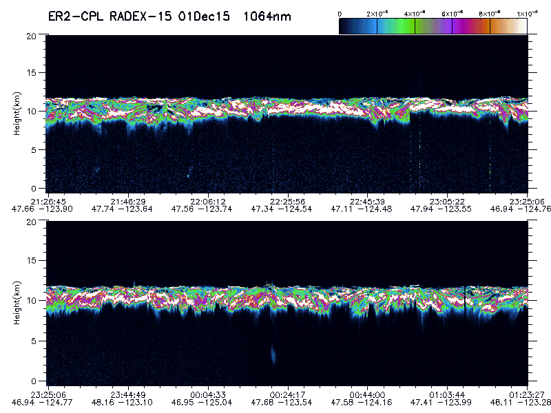
GPM Ground Validation Cloud Physics LiDAR (CPL) OLYMPEX V1
National Aeronautics and Space Administration —
The GPM Ground Validation Cloud Physics Lidar (CPL) OLYMPEX dataset consists of extinction profiles, layer optical depth, layer lidar ratio, and aircraft parameter... -
Federal
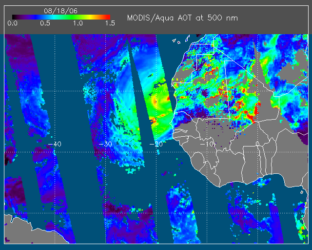
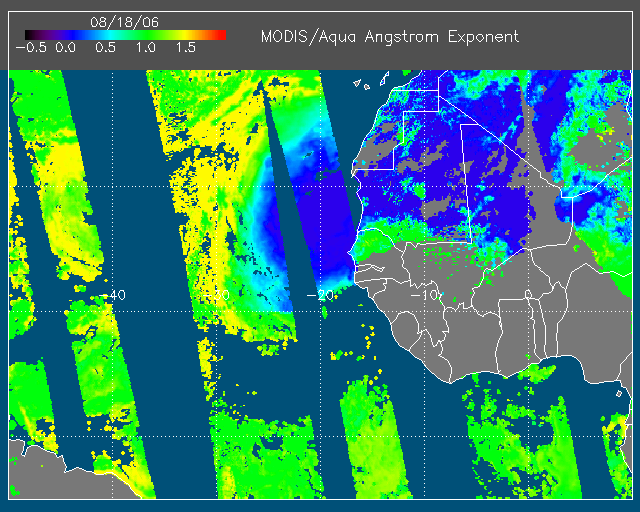
NAMMA MODIS/AQUA AND MODIS/TERRA DEEP BLUE PRODUCTS V1 NGDA
National Aeronautics and Space Administration —
The NAMMA MODIS/AQUA and MODIS/TERRA Deep Blue Products dataset is a collection of images depicting the aerosol optical depth derived from the MODIS deep blue... -
Federal
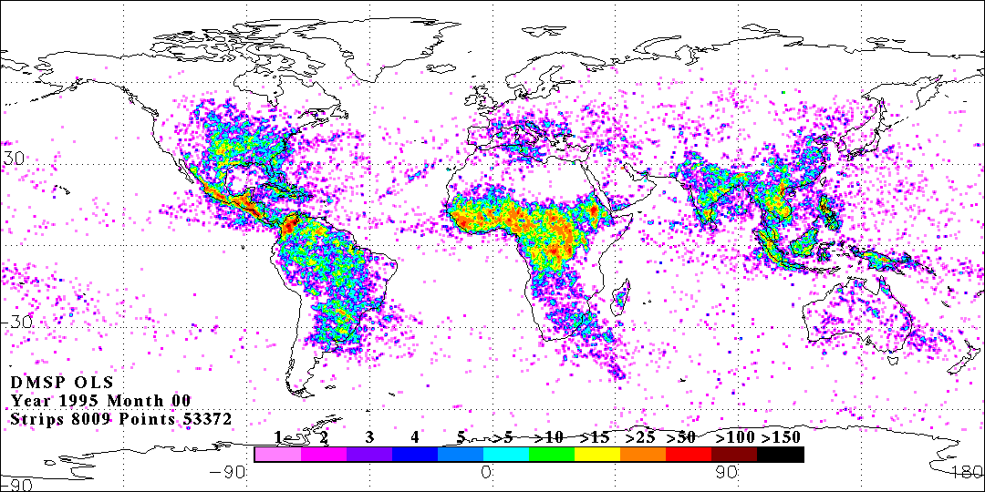
OLS DIGITAL DERIVED LIGHTNING FROM DMSP F12 V1
National Aeronautics and Space Administration —
The OLS Digital Derived Lightning from DMSP F12 dataset consists of global lightning signatures from the Defense Meteorological Satellite Program (DMSP) Operational... -
Federal
GPM Ground Validation CXSI Radar Imagery OLYMPEX V1
National Aeronautics and Space Administration —
The GPM Ground Validation CXSI Radar Imagery OLYMPEX dataset contains radar reflectivity and precipitation rate images obtained from Environment and Climate Change... -
Federal
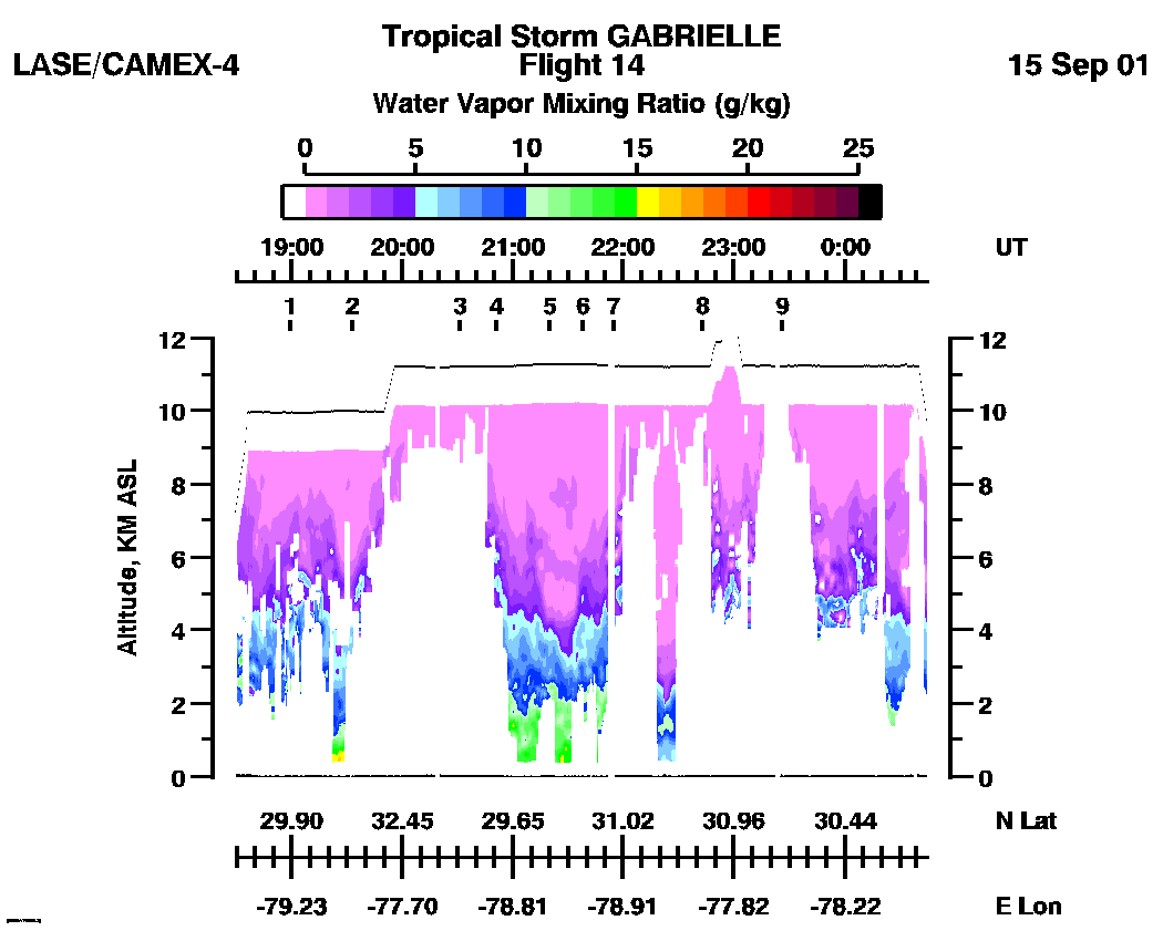
CAMEX-4 LIDAR ATMOSPHERIC SENSING EXPERIMENT (LASE) V1
National Aeronautics and Space Administration —
The CAMEX-4 LIDAR Atmospheric Sensing Experiment (LASE) dataset was collected by the LASE instrument, which is an airborne DIAL (Differential Absorption Lidar) system... -
Federal
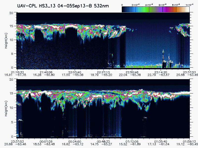
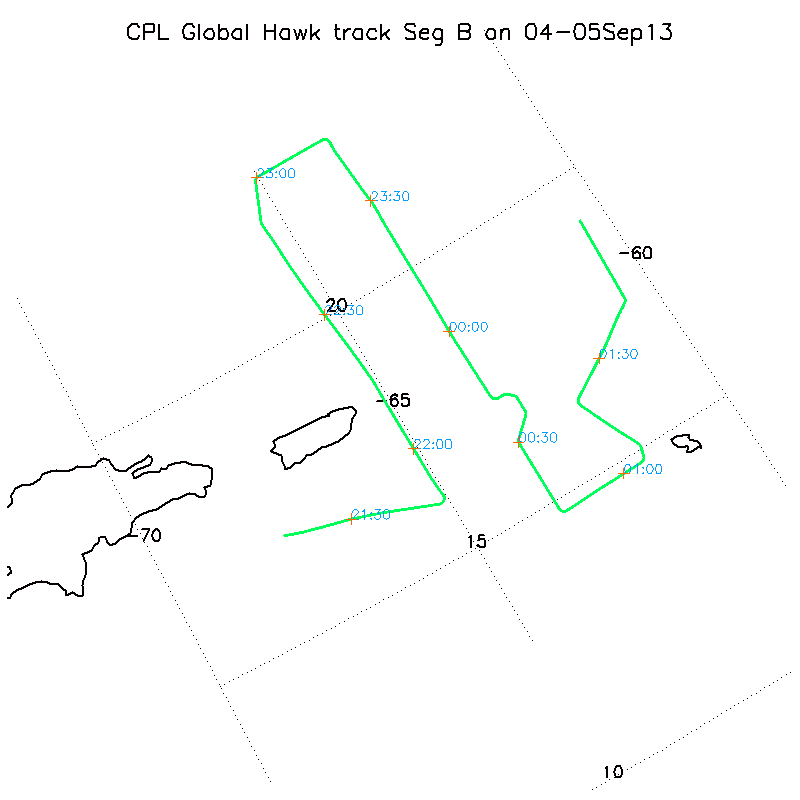
HURRICANE AND SEVERE STORM SENTINEL (HS3) GLOBAL HAWK CLOUD PHYSICS LIDAR (CPL) V1
National Aeronautics and Space Administration —
The Hurricane and Severe Storm Sentinel (HS3) Global Hawk Cloud Physics Lidar (CPL) dataset includes measurements gathered by the CPL instrument during the HS3... -
Federal
ISLSCP II Atmospheric Carbon Dioxide Consumption by Continental Erosion
National Aeronautics and Space Administration —
The Continental Atmospheric CO2 Consumption data set represents gridded estimates for the riverine export of carbon and of sediments based on empirical models. All... -
Federal
BOREAS Follow-On DSP-01 NBIOME Level-4 AVHRR Land Cover, Canada, Ver. 1.1, 1995
National Aeronautics and Space Administration —
This land cover product was produced by NBIOME to generate an up-to-date, spatially and temporally consistent land cover map of the landmass of Canada for use by... -
Federal
BOREAS/SRC AMS Suite A Surface Meteorological and Radiation Data: 1994
National Aeronautics and Space Administration —
Contains the data collected in 1994 by the AMS suite A instrument set operated by SRC and provided to BORIS. -
Federal
AIRS/Aqua L3 Monthly Quantization in Physical Units (AIRS+AMSU) 5 degrees x 5 degrees V006 (AIRX3QPM) at GES DISC
National Aeronautics and Space Administration —
The Atmospheric Infrared Sounder (AIRS) is a grating spectrometer (R = 1200) aboard the second Earth Observing System (EOS) polar-orbiting platform, EOS Aqua. In... -
Federal
AIRS/Aqua L3 5-day Quantization in Physical Units (AIRS+AMSU) 5 degrees x 5 degrees V006 (AIRX3QP5) at GES DISC
National Aeronautics and Space Administration —
The Atmospheric Infrared Sounder (AIRS) is a grating spectrometer (R = 1200) aboard the second Earth Observing System (EOS) polar-orbiting platform, EOS Aqua. In... -
Federal
AIRS/Aqua L3 5-day Quantization in Physical Units (AIRS+AMSU+HSB) 5 degrees x 5 degrees V006 (AIRH3QP5) at GES DISC
National Aeronautics and Space Administration —
The Atmospheric Infrared Sounder (AIRS) is a grating spectrometer (R = 1200) aboard the second Earth Observing System (EOS) polar-orbiting platform, EOS Aqua. In... -
Federal
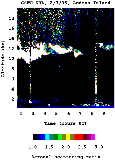
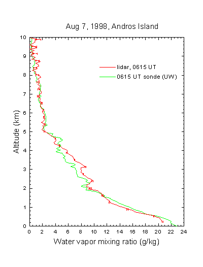
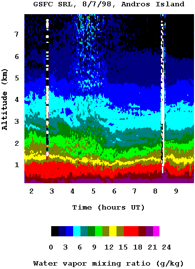
CAMEX-3 SCANNING RAMAN LIDAR V1
National Aeronautics and Space Administration —
The CAMEX-3 Scanning Raman LIDAR dataset collected data during the CAMEX-3 campaign on Andros Island during the period 6 August - 20 September 1998. The SRL...

Official websites use .gov
A
.gov website belongs to an official government
organization in the United States.
Secure .gov websites use HTTPS
A
lock (
) or https:// means you’ve safely connected to
the .gov website. Share sensitive information only on official,
secure websites.